Zitierweise / cite as:
Payer, Alois <1944 - >: Quellenkunde zur indischen Geschichte bis 1858. -- 11. Griechische und lateinische Quellen. -- 1. Zum Beispiel: Periplus Maris Erythraei -- Περίπλους της Ερυθράς Θαλάσσης. -- Fassung vom 2008-04-20. -- http://www.payer.de/quellenkunde/quellen1101.htm
Erstmals publiziert als:
The commerce and navigation of the Erythraean Sea : being translations of the "Periplus maris Erythraei" by an anonymous writer and partly from Arrian’s account of the voyage of Nearkhos ; followed by Ancient India as described by Ktesias the Knidian : being a translation of the abridgement of his "Indika" by Photios and of the fragments of that work preserved in other writers / edited, with historical introductions, commentary, critical notes, and indexes [by] J. W. (John Watson) McCrindle [1825 - 1913]. -- London : Trübner, 1879. -- S. 107 - 149. -- Online: http://www.archive.org/details/commercenavigati00mccrrich. -- Zugriff am 2008-04-19. -- "Not in copyright"
Erstmals hier publiziert: 2008-04-20
Überarbeitungen:
Anlass: Lehrveranstaltung FS 2008
©opyright: Public domain.
Dieser Text ist Teil der Abteilung Sanskrit von Tüpfli's Global Village Library
Falls Sie die diakritischen Zeichen nicht dargestellt bekommen, installieren Sie eine Schrift mit Diakritika wie z.B. Tahoma.
Handschrift des Periplus (Περίπλους της Ερυθράς Θαλάσσης), UB Heidelberg Cod. Pal. graec. 398: http://digi.ub.uni-heidelberg.de/diglit/cpgraec398/0084. -- Zugriff am 2008-04-19]
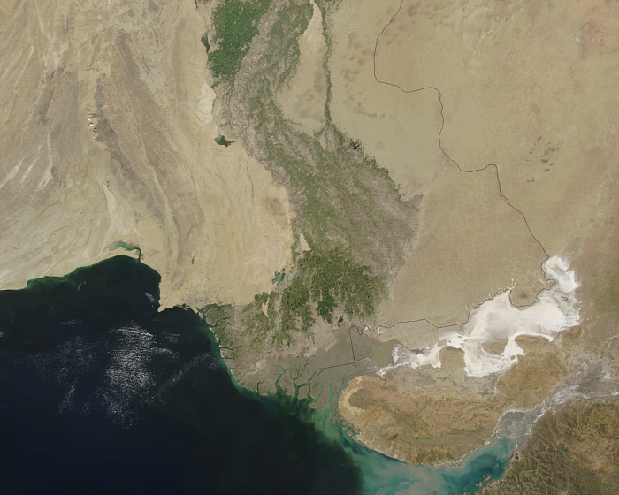
Abb.: Mündungsgebiet des Indus
[Bildquelle: NASA:
http://visibleearth.nasa.gov/view_rec.php?id=4716. -- Zugriff am 2008-04-19]
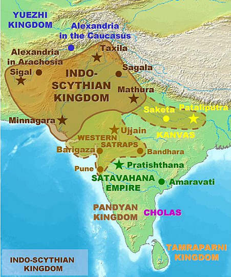
Abb.: Ungefähre vermutliche Ausbreitung des indo-skythischen Reichs
[Bildquelle: Wikipedia, GNU FDLicense]
38. After this region, where the coast is already deeply indented by gulfs caused by the land advancing with a vast curve from the east, succeeds the seaboard of Skythia, a region which extends to northward. It is very low and flat, and contains the mouths of the Sinthos (Indus), the largest of all the rivers which fall into the Erythraean Sea, and which, indeed, pours into it such a vast body of water that while you are yet far off from the land at its mouth you find the sea turned of a white colour by its waters.
The sign by which voyagers before sighting [S. 108] land know that it is near is their meeting with serpents floating on the water ; but higher up and on the coasts of Persia the first sign of land is seeing them of a different kind, called graai. [Sansk. graha -- an alligator.] The river has seven mouths, all shallow, marshy and unfit for navigation except only the middle stream, on which is Barbarikon, a trading seaport. Before this town lies a small islet, and behind it in the interior is Minnagar, the metropolis of Skythia, which is governed, however, by Parthian princes, who are perpetually at strife among themselves, expelling each the other.
(38) We now approach the mouths of the Indus which our author calls the Sinthos, transliterating the native name of it Sindhu. In his time the wide tract which was watered by this river in the lower part of its course was called Indoskythia. It derived its name from the Skythian tribes (the Śaka of Sansk.) who after the overthrow of the Graeco-Baktrian empire gradually passed southward to the coast, where they established themselves about the year 120 B. C., occupying all the region between the Indus and the Narmadā. They are called by Dionysios Periegetes Notioi Skythai, the Southern Skythians. Our author mentions two cities which belonged to them Barbarikon and Minnagar; the former of which was an emporium situated near the sea on the middle and only navigable branch of the Indus. Ptolemy has a Barbarei in the Delta, but the position he assigns to it, does not correspond with that of Barbarikon. Minnagar was the Skythian metropolis. It lay inland, on or near the banks of the Indus.
39. Ships accordingly anchor near Barbarikē, but all their cargoes are conveyed by the river up to the king, who resides in the metropolis.
The articles imported into this emporium are
Clothing, plain and in considerable quantity. [S. 109]
Clothing, mixed, not much.
Flowered cottons.
Yellow-stone, topazes.
Coral .
Storax1.
Frankincense (Lobān)2.
Glass vessels.
Silver plate.
Specie.
Wine, but not much.
The exports are :
Costus, a spice3.
Bdellium, a gum4.
A yellow dye (Ruzot).
Spikenard 5.
Emeralds or green-stones.
Sapphires.
Furs from China.
Cottons.
Silk thread.
Indigo6.
Erklärungen:
1 Styrax/Storax: wohlriechendes Baumharz des Storaxbaums (Styrax officinalis), das für Räucherwerke oder als Heilmittel verwendet wird.
2 Weihrauch (لبٌان, lubbān): zum Räuchern verwendetes Hard von Bäumen der Gattung Boswellia
3 Costus: vermutlich die getrocknete Wurzel von Saussurea lappa, die entzündungshemmend wirkt.
4 Bedolachharz / Bdelliumharz / Falsche Myrrhe: Harz des südarabischen Balsambaumes Commiphora mukul, als Duftstoff und zum Räuchern verwendet
5 Indische Narde / Nardenähre (Nardostachys jatamansi): aus der Wurzel werden kostbare Öle und Salben gewonnen.
6 Indigopflanze (Indigofera tinctoria): zur Blaufärberei verwendet
[S. 110] Ships destined for this port put out to sea when the Indian monsoon prevails -- that is, about the month of July or Epiphi. The voyage at this season is attended with danger, bat being shorter is more expeditious.
(39) Ships did not go up to it but remained at Barbarikon, their cargoes being conveyed up the river in small boats. In Ptolemy (VII. i. 61) the form of the name is Binagara, which is less correct since the word is composed of Min, the Indian name for the Skythians, and nagar, a city. Ritter considers that Ṭhaṭha is its modern representative, since it is called Saminagar by the Jāḍejā Rājputs who, though settled in Kachh, derive their origin from that city. To this view it is objected that Ṭhaṭha is not near the position which Ptolemy assigns to his Binagara. Mannert places it at Bakkar, D'Anville at Mansura, and Vincent at Menhabery mentionedby Edrisi (I. p. 164) as distant two stations or 60 miles from Dabil, which again was three stations or 90 miles from the mouth of the Indus, that is it lay at the head of the Delta. Our author informs us that in his time Minagar was ruled by Parthian princes. The Parthians (the Parada of Sanskrit writers) must therefore have subverted a Skythian dynasty which must have been that which (as Benfey has shown) was founded by Yeukaotschin between the years 30 and 20 B.C., or about 30 years only after the famous Indian Aera, called Śākābda (the year of the Śaka) being that in which Vikramāditya expelled the Skythians from Indian soil. The statement of the Periplus that Parthian rulers succeeded the Skythian is confirmed by Parthian coins found everywhere in this part of the country. These sovereigns must have been of consequence, or the trade of their country very lucrative to the merchant as appears by the presents necessary to ensure his protection plate, musical instruments, handsome girls for the Harem, the best wine, plain cloth of high price, and the finest perfumes. The profits of the trade must therefore have been great, but if Pliny's account be true, that every pound laid out in India produced a hundred at Rome, greater exactions than these might easily have been supported.
[S. 111] 40. After the river Sinthos is passed we reach another gulf, which cannot be easily seen. It has two divisions, the Great and the Little by name, both shoal with violent and continuous eddies extending far out from the shore, so that before ever land is in sight ships are often grounded on the shoals, or being caught within the eddies are lost. Over this gulf hangs a promontory which, curving from Eirinon first to the east, then to the south, and finally to the west, encompasses the gulf called Barakē, in the bosom of which lie seven islands. Should a vessel approach the entrance of this gulf, the only chance of escape for those on board is at once to alter their course and stand out to sea, for it is all over with them if they are once fairly within the womb of Barakē, [S. 112] which surges with vast and mighty billows, and where the sea, tossing in violent commotion, forms eddies and impetuous whirlpools in every direction. The bottom varies, presenting in places sudden shoals, in others being scabrous with jagged rocks, so that when an anchor grounds its cable is either at once cut through, or soon broken by friction at the bottom. The sign by which voyagers know they are approaching this bay is their seeing serpents floating about on the water, of extraordinary size and of a black colour, for those met with lower down and in the neighbourhood of Barugaza are of less size, and in colour green and golden.
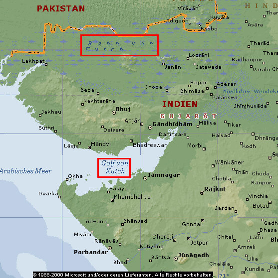
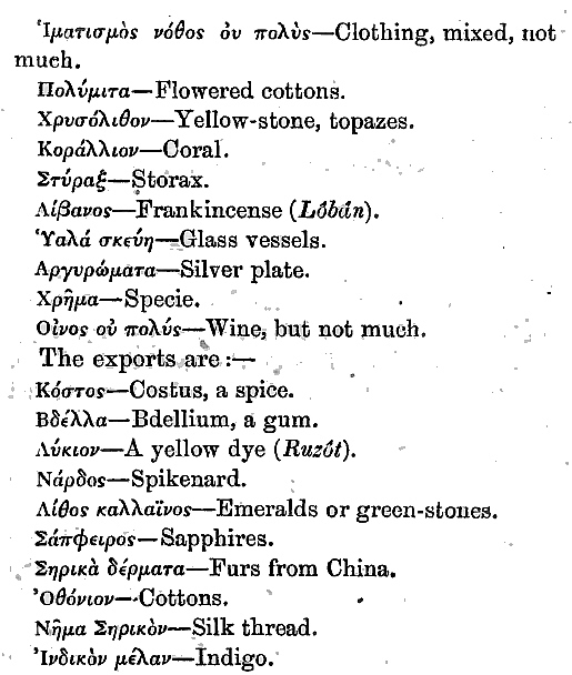
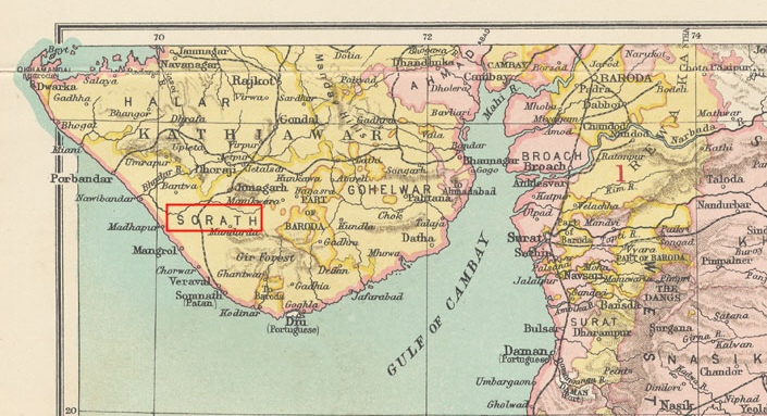
Abb.: Rann von Kutch und Golf von Kutch
(©MS Encarta)
(40) The first place mentioned after the Indus is the Gulf of Eirinon, a name of which traces remain in the modern appellation the Raṇ of Kachh. This is no longer covered with water except during the monsoon, when it is flooded by sea water or by rains and inundated rivers. At other seasons it is not even a marsh, for its bed is hard, dry and sandy ; a mere saline waste almost entirely devoid of herbage, and frequented but by one quadruped the wild ass. Burnes conjectured that its desiccation resulted from an upheaval of the earth caused by one of those earthquakes which are so common in that part of India. The Raṇ is connected with the Gulf of Kachh, which our author calls the Gulf of Barakē. His account of it is far from clear. Perhaps, as Müller suggests, he comprehended under Eirinon the interior portion of the Gulf of Kachh, limiting the Gulf of Barakē to the exterior portion or entrance to it. This gulf is called that of Kanthi by Ptolemy, who mentions Barakē only as an island, [and the south coast of Kachh is still known by the name of Kantha]. The islands of the Periplūs extend westward from the neighbourhood of Navanagar to the very entrance of the Gulf.
41. To the gulf of Barakē succeeds that [S. 113] of Barugaza and the mainland of Ariaka, a district which forms the frontier of the kingdom of Mombaros and of all India. The interior part of it which borders on Skythia is called Abēria, and its sea-board Surastrēnē. It is a region which produces abundantly corn and rice and the oil of sesamum, butter, muslins and the coarser fabrics which are [S. 114] manufactured from Indian cotton. It has also numerous herds of cattle. The natives are men of large stature and coloured black. The metropolis of the district is Minnagar, from which [S. 115] cotton cloth is exported in great quantity to Barugaza. In this part of the country there are preserved even to this very day memorials of the expedition of Alexander, old temples, foundations of camps, and large wells. The extent of this coast, reckoned from Barbarikon to the promontory called Papikē, near Astakapra, which is opposite Barugaza, is 3,000 stadia.
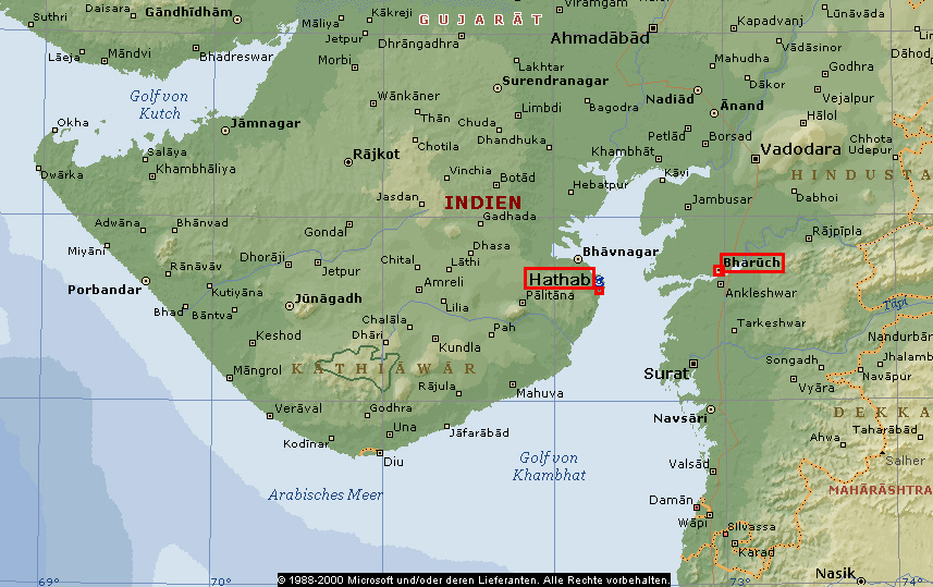
Abb.: Lage von Barugaza (heute: Bharūch/भरूच), Astakapra (heute: Hāthab), Surastrēnē (Saurashtra = südliches Kathiāwār/કાઠીયાવાડ),
Golf von Khambhāṭ / खम्भाट
(©MS Encarta)
(41) To Barakē succeeds the Gulf of Barugaza (Gulf of Khambhāt) and the sea-board of the region called Ariakē. The reading of the MS. here [...] is considered corrupt. Müller substitutes [...] , though Mannert and others prefer [...], relying on Ptolemy, who places Ariakē to the south of Larikē, and says that Larikē comprehends the peninsula (of Gujarāt) Barugaza and the parts adjacent. As Ariakē was however previously mentioned in the Periplūs (sec. 14) in connexion with Barugaza, and is afterwards mentioned (sec. 54) as trading with Muziris, it must no doubt have been mentioned by the author in its proper place, which is here. [Bhagvanlāl Indraji Pandit has shewn reasons however for correcting the readings into [...], the Prakrit form of Aparāntikā, an old name of the western sea board of India. Ind. Ant. vol. VII., pp. 259, 263.] Regarding the name Larikē, Yule has the following note (Travels of M. Polo vol. II, p. 353) : "Lār-Deśa, the country of Lar," properly Lāt-deśa, was an early name for the territory of Gujrat and the northern Konkan, embracing Saimur (the modern Chaul as I believe) Thaṇa, and Bharoch. It appears in Ptolemy in the form Larikē. The sea to the west of that coast was in the early Muhammadan times called the sea of Lār, and the language spoken on its shores iscalled by Mas'udi, Lāri. Abulfeda's authority, Ibn Said, speaks of Lār and Gujarāt as identical."
Ariakē (Aparāntikā), our author informs us, was the beginning or frontier of India. That part of the interior of Ariakē which bordered on Skythia was called Aberia or Abiria (in the MS. erroneously Ibēria). The corresponding Indian word is Abhīra, which designated the district near the mouths of the river. Having been even in very early times a great seat of commerce, some (as Lassen) have been led to think from a certain similarity of the names that this was the Ophir of scripture, a view opposed by Ritter. Abiria is mentioned by Ptolemy, who took it to be not a part of India but of Indoskythia. The sea-board of Ariakē was called Surastrēnē, and is mentioned by Ptolemy, who says (VII. i. 55) it was the region about the mouths of the Indus and the Gulf of Kanthi. It answers to the Sanskrit Surāshṭra. Its capital was Minnagar, -- a city which, as its name shows, had once belonged to the Min or Skythians. It was different of course from the Minnagar already mentioned as the capital of Indo-Skythia. It was situated to the south of Ozēnē (Ujjayinī, or Ujjain), and on the road which led from that city to the River Narmadā, probably near where Indor now stands. It must have been the capital only for a short time, as Ptolemy informs us (II. i. 63) that Ozēnē was in his time the capital of Tiashanes [probably the Chashṭana of Coins and the Cave Temple inscriptions]. From both places a great variety of merchandise was sent down the Narmadā to Barugaza.
The next place our author mentions is a promontory called Papikē projecting into the Gulf of Khambāt from that part of the peninsula of Gujarāt which lies opposite to the Barugaza coast. Its distance from Barbarikon on the middle mouth of the Indus is correctly given at 3,000 stadia. This promontory is said to be near Astakapra, a place which is mentioned also by Ptolemy, and which (Ind. Ant. vol. V. p. 314) has been identified by Colonel Yule with Hastakavapra (now Hāthab near Bhaunagar), a name which occurs in a copper-plate grant of Dhruvasena I of Valabhi. With regard to the Greek form of this name Dr. Bühler thinks it is not derived immediately from the Sanskrit, but from an intermediate old Prakrit word Hastakampra, which had been formed by the contraction of the syllables ava to ā, and the insertion of a nasal, according to the habits of the Gujarātīs. The loss of the initial, he adds, may be explained by the difficulty which Gujarātīs have now and probably had 1,600 years ago in pronouncing the spirans in its proper place. The modern name Hāthab or Hāthap may be a corruption of the shorter Sanskrit form Hastavapra.
[S. 116] 42. After Papikē there is another gulf, exposed to the violence of the waves and running up to the north. Near its mouth is an island called Baionēs, and at its very head it receives a vast river called the Maīs. Those bound for Barugaza sail up this gulf (which has a breadth of about 300 stadia), leaving the island on the left till it is scarcely visible in the horizon, when they shape their course east for the mouth of the river that leads to Barugaza. This is called the Namnadios.
(42) Beyond Papikē, we are next informed, there is another gulf running northward into the interior of the country. This is not really another Gulf but only the northern portion of the Gulf of Khambāt, which the Periplūs calls the Gulf of Barugaza. It receives a great river, the Mais, which is easily identified with the Mahi, and contains an island called Baiōnēs [the modern Peram], which you leave on the left hand as you cross over from Astakapra to Barugaza.
We are now conducted to Barugaza, the greatest seat of commerce in Western India, situated on a river called in the MS. of the Periplūs the Lamnaios, which is no doubt an erroneous reading for Namados, or Namnados or Namnadios. This river is the Narmadā. It is called by Ptolemy the Namadēs.
Abb.: Die Narmadā (નર્મદા, नर्मदा)
(©MS Encarta)
[S. 117] 43. The passage into the gulf of Barugaza is narrow and difficult of access to those approaching it from the sea, for they are carried either to the right or to the left, the left being the better passage of the two. On the right, at the very entrance of the gulf, lies a narrow stripe of shoal, rough and beset with rocks. It is called Hērōnē, and lies opposite the village of Kammōni. On the left side right against this is the promontory of Papikē, which lies in front of Astakapra, where it is difficult to anchor, from the strength of the current and because the cables are cut through by the sharp rocks at the bottom. But even if the passage into the gulf is secured the mouth of the Barugaza river is not easy to hit, since the coast is low and there are no certain marks to be seen until you are close upon them. Neither, if it is discovered, is it easy to enter, from the presence of shoals at the mouth of the river.
(43) Barugaza (Bharoch) which was 30 miles distant from its mouth, was both difficult and dangerous of access ; for the entrance to the Gulf itself was, on the right, beset with a perilous stripe (tainia) of rocky shoal called Herōnē, and on the left, (which was the safer course,) the violent currents which swept round the promontory of Papikē rendered it unsafe to approach the shore or to cast anchor. The shoal of Herōnē was opposite a village on the mainland called Kammōni, the Kamanē of Ptolemy (VII. i.), who however places it to the north of the river's mouth. Again, it was not only difficult to hit the mouth of the river, but its navigation was endangered by sandbanks and the violence of the tides, especially the high tide called the 'Bore,' of which our author gives a description so particular and so vivid as suffices to show that he was describing what he had seen with his own eyes, and seen moreover for the first time. With regard to the name Barugaza the following passage, which I quote from Dr. Wilson's Indian Castes (vol. II. p. 113) will elucidate its etymology : "The Bhārgavas derive their designation from Bhargava, the adjective form of Bhṛigu, the name of one of the ancient Ṛishis. Their chief habitat is the district of Bharoch, which must have got its name from a colony of the school of Bhṛigu having been early established in this Kshetra, probably granted to them by some conqueror of the district. In the name Barugaza given to it by Ptolemy, we have a Greek corruption of Bhṛigukshetra (the territory of Bhṛigu) or Bhṛigukachha (the tongueland of Bhṛigu)." Speaking of the Bhārgavas Dr. Drummond, in his Grammatical Illustrations, says : "These Brāhmans are indeed poor and ignorant. Many of them, and other illiterate Gujarātis, would, in attempting to articulate Bhṛigukshetra, lose the half in coalesence, and call it Bargacha, whence the Greeks, having no Ch, wrote it Barugaza."
[S. 118] 44. For this reason native fishermen appointed by Government are stationed with well-manned long boats called trappaga and kotumba at the entrance of the river, whence they go out as far as Surastrēnē to meet ships, and pilot them up to Barugaza. At the head of the gulf the pilot, immediately on taking charge of a ship, with the help of his own boat's crew, shifts her head to keep her clear of the shoals, and tows her from one fixed station to another, moving with the beginning of the tide, and dropping anchor at certain roadsteads and basins when it ebbs. These basins occur at points where the river is deeper than usual, all the way up to Barugaza, which is 300 stadia distant from the mouth of the river if you sail up the stream to reach it.
45. India has everywhere a great abundance of rivers, and her seas ebb and flow with tides of extraordinary strength, which increase with [S. 119] the moon, both when new and when full, and for three days after each, but fall off in the intermediate space. About Barugaza they are more violent than elsewhere ; so that all of a sudden you see the depths laid bare, and portions of the land turned into sea, and the sea, where ships were sailing but just before, turned without warning into dry land. The rivers, again, on the access of flood tide rushing into their channels with the whole body of the sea, are driven upwards against their natural course for a great number of miles with a force that is irresistible.
46. This is the reason why ships frequenting this emporium are exposed, both in coming and going, to great risk, if handled by those who are unacquainted with the navigation of the gulf or visit it for the first time, since the impetuosity of the tide when it becomes full, having nothing to stem or slacken it, is such that [S. 120] anchors cannot hold against it. Large vessels, moreover, if caught in it are driven athwart from their course by the rapidity of the current till they are stranded on shoals and wrecked, while the smaller craft are capsized, and many that have taken refuge in the side channels, being left dry by the receding tide, turn over on one side, and, if not set erect on props, are filled upon the return of the tide with the very first head of the flood, and sunk. But at new moons, especially when they occur in conjunction with a night tide, the flood sets in with such extraordinary violence that on its beginning to advance, even though the sea be calm, its roar is heard by those living near the river's mouth, sounding like the tumult of battle heard far off, and soon after the sea with its hissing waves bursts over the bare shoals.
47. Inland from Barugaza the country is inhabited by numerous races the Aratrioi, and the Arakhōsioi, and the Gandaraioi, and the people of Proklaïs, in which is Boukephalos Alexandreia. Beyond these are the Baktrianoi, a most warlike race, governed by their own independent sovereign. It was from these parts Alexander issued to invade India when he marched as far as the Ganges, without, however, attacking Limurikē and the southern parts of the country. Hence up to the present day old drachmai bearing the [S. 122] Greek inscriptions- of Apollodotos and Menander are current in Barugaza.
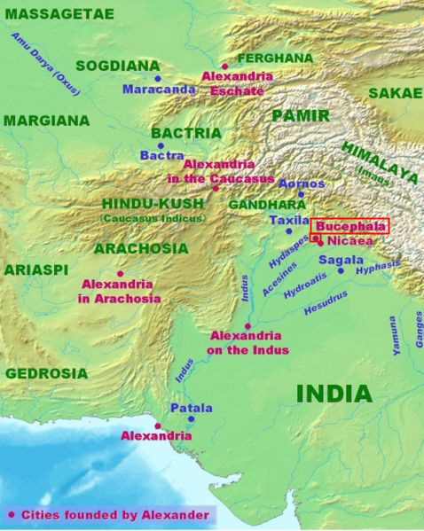
Abb.: Lage von Alexandreia Bukephalos/ Αλεξάνδρεια βουκεφάλος
[Bildquelle: Wikipedia, Public domain]
(47) The account of the ' bore' is followed by an enumeration of the countries around and beyond Barugaza with which it had commercial relations. Inland are the Aratrioi, Arakhōsioi, Gandarioi and the people of Proklaïs, a province wherein is Boukephalos Alexandreia, beyond which is the Baktrian nation. It has been thought by some that by the Aratrioi are meant the Arii, by others that they were the Arāstrās of Sanskrit called Aratti in the Prakrit, so that the Aratrioi of the Periplūs hold an intermediate place between the Sanskrit and Prakrit form of the name. Müller however says "if you want a people known to the Greeks and Romans as familiarly as the well-known names of the Arakhosii, Gandarii, Peukelitae, you may conjecture that the proper reading is ΑΡΑΓΓΩΝ instead of ΑΡΑΤΡΙΩΝ. It is an error of course on the part of our author when he places Boukephalos (a city built by Alexander on the banks of the Hydaspēs, where he defeated Pōros), in the neighbourhood of Proklais, that is Pekhely in the neighbourhood of Peshawar. He makes a still more surprising error when he states that Alexander penetrated to the Ganges.
48. In the same region eastward is a city called Ozēnē, formerly the capital wherein the king resided. From it there is brought down to Barugaza every commodity for the supply of the country and for export to our own markets onyx-stones, porcelain, fine muslins, mallow-coloured muslins, and no small quantity of ordinary cottons. At the same time there is brought down to it from the upper country by way of Proklaïs, for transmission to the coast, Kattybourine, Patropapigic, and Kabalitic spikenard, and another kind which reaches it by way of the adjacent province of Skythia ; also kostus and bdellium.
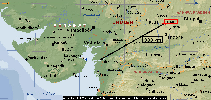
Abb.: Lage von Ozēnē = Ujjain / उज्जैन
(©MS Encarta)
(48) The next place mentioned in the enumeration is Ozēnē (Ujjain), which, receiving nard through Proklaïs from the distant regions where it was produced, passed it on to the coast for export to the Western World. This aromatic was a product of three districts, whence its varieties were called respectively the Kattybourine, the Patropapiyic and the Kabolilic. What places were indicated by the first two names cannot be ascertained, but the last points undoubtedly to the region round Kābul, since its inhabitants are called by Ptolemy Kabolitai, and Edrisi uses the term Myrobalanos Kabolinos for the 'myrobolans of Kabul.' Nard, as Edrisi also observes, has its proper soil in Thibet.
49. The imports of Barugaza are
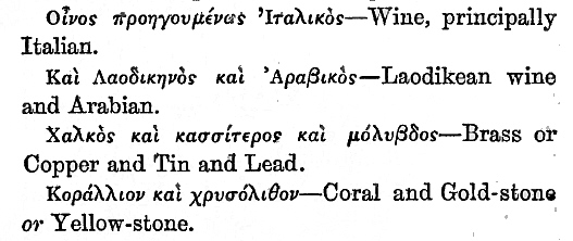
Wine, principally Italian.
Laodikean wine and Arabian.
Brass or Copper and Tin and Lead.
Coral and Gold-stone or Yellow-stone. [S. 123]
Cloth, plain and mixed, of all sorts.
Variegated sashes half a yard wide.
Storax1.
Sweet clover, melilot2.
White glass.
Gum Sandarach3.
(Stibium) Tincture for the eyes, Sūrmā4.
Gold and Silver specie, yielding a profit when exchanged for native money.
Perfumes or unguents, neither costly nor in great quantity.
Erklärungen:
1 Styrax/Storax: wohlriechendes Baumharz des Storaxbaums (Styrax officinalis), das für Räucherwerke oder als Heilmittel verwendet wird.
2 Steinklee (Melilotus): vermutlich medizinisch verwendet (Melilotus officinalis)
3 Sandarak: Harz der Konifere, Sandarakbaum (Tetraclinis articulata), zum Räuchern verwendet
4 Kajal (काजल, kājal) / Khol: schwarze Augenschmike
In those times, moreover, there were imported, as presents to the king, costly silver vases, instruments of music, handsome young women for concubinage, superior wine, apparel, plain but costly, and the choicest unguents. The exports from this part of the country are
Spikenard1, Costus2, bdellium3, ivory.
Onyx-stones and porcelain.
Ruzot, Box-thorn4. [S. 124]
Cottons of all sorts.
Silk.
Mallow-coloured cottons.
Silk thread.
Long pepper and other articles supplied from the neighbouring ports.
The proper season to set sail for Barugaza from Egypt is the month of July, or Epiphi.
Erklärungen:
1 Indische Narde / Nardenähre (Nardostachys jatamansi): aus der Wurzel werden kostbare Öle und Salben gewonnen.
2 Costus: vermutlich die getrocknete Wurzel von Saussurea lappa, die entzündungshemmend wirkt.
3 Bedolachharz / Bdelliumharz / Falsche Myrrhe: Harz des südarabischen Balsambaumes Commiphora mukul, als Duftstoff und zum Räuchern verwendet
4 Bocksdorn: Lycium sp., wurde medizinisch verwendet
50. From Barugaza the coast immediately adjoining stretches from the north directly to the south, and the country is therefore called Dakhinabadēs, because Dakhan in the language of the natives signifies south. Of this country that part which lies inland towards the east comprises a great space of desert country, and large mountains abounding with all kinds of wild animals, leopards, tigers, elephants, huge snakes, hyenas, and baboons of many different sorts, and is inhabited right across to the Ganges by many and extremely populous nations.
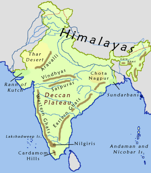
Abb.: Dakhinabādes = Dakṣiṇāpatha: Westghats (ಸಹ್ಯಾದ್ರಿ, सह्यद्रि, மேற்கு
தொடர்ச்சி மலை ) und das Dekkhanplateau (दख्खन)
[Bildquelle: Wikipedia, GNU FDLicense]
(50) Barugaza had at the same time commercial relations with the Dekhan also. This part of India our author calls Dakhinabadēs, transliterating the word Dakshināpatha (the Dakshinā, or the South Country). "Here," says Vincent, "the author of the Periplūs gives the true direction of this western coast of the Peninsula, and states in direct terms its tendency to the South, while Ptolemy stretches out the whole angle to a straight line, and places the Gulf of Cambay almost in the same latitude as Cape Comorin."
[S. 125] 51. Among the marts in this South Country there are two of more particular importance Paithana, which lies south from Barugaza, a distance of twenty days, and Tagara, ten days east of Paithana, the greatest city in the country. Their commodities are carried down on wagons to Barugaza along roads of extreme difficulty, that is, from Paithana a great [S. 126] quantity of onyx-stone, and from Tagara ordinary cottons in abundance, many sorts of muslins, mallow-coloured cottons, and other articles of local production brought into it from the parts along the coast. The length of the entire voyage as far as Limurikē is 700 stadia, and to reach Aigialos you must sail very many stadia further.
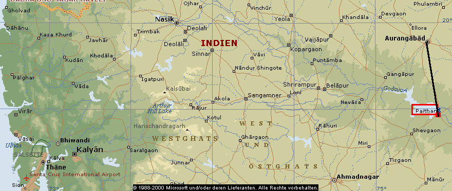
Abb.: Lage von Paithan (पैठण)
(©MS Encarta)
(51) In the interior of the Dekhan, the Periplūs places two great seats of commerce, Paithana, 20 days' journey to the south of Barugaza, and Tagara, 10 days' journey eastward from Paithana. Paithana, which appears in Ptolemy as Baithana, may be identified with Paithana. Tagara is more puzzling. Wilford, Vincent, Mannert, Ritter and others identify it with Devagiri or Deogarh, near Elurā, about 8 miles from Aurangābād. The name of a place called Tagarapura occurs in a copper grant of land which was found in the island of Salsette. There is however nothing to show that this was a name of Devagiri. Besides, if Paithana be correctly identified, Tagara cannot be Devagiri unless the distances and directions are very erroneously given in the Periplūs. This is not improbable, and Tagara may therefore be Junnar (i.e. Jūna-nagar = the old city), which from its position must always have been an emporium, and its Buddha caves belong to about B. C. 100 to A.D. 150 (see Archaeolog. Surv. of West. India, vol. III., and Elphinstone's History of India, p. 223).
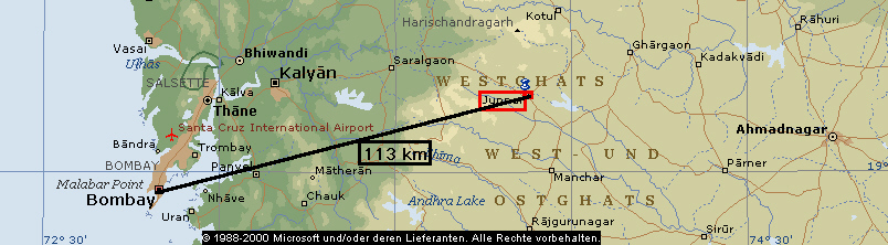
Abb.: Lage von Junnar (जुन्नर)
(©MS Encarta)
Our author introduces us next to another division of India, that called Limurikē, which begins, as he informs us, at a distance of 7,000 stadia (or nearly 900 miles) beyond Barugaza. This estimate is wide of the mark, being in fact about the distance between Barugaza and the southern or remote extremity of Limurikē. In the Indian segment of the Roman maps called from their discoverer, the Peutinger Tables, the portion of India to which this name is applied is called Damirikē. We can scarcely err, says Dr. Caldwell (Dravid. Gram. Intr. page 14), in identifying this name with the Tamiḻ country. If so, the earliest appearance of the name Tamiḻ in any foreign documents will be found also to be most perfectly in accordance with the native Tamil mode of spelling the name. Damirikē evidently means Damir-ike ... In another place in the same map a district is called Scytia Dymirice; and it appears to have been this word which by a mistake of Δ for Λ Ptolemy wrote Δυμιρικη). The D retains its place however in the Cosmography of the anonymous geographer of Ravenna, who repeatedly mentions Dimirica as one of the three divisions of India and the one furthest to the East. He shows also that the Tamil country must have been meant by the name by mentioning Modura as one of the cities it contained.
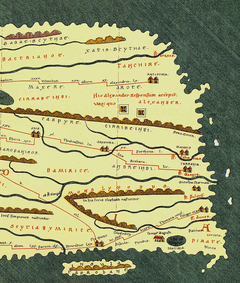
Abb.: Peutingersche Tafel, Faksimile, Ausschnitt "Indien"
[Bildquelle: Wikipedia, Public domain]
[S. 127] 52. The local marts which occur in order along the coast after Barugaza are Akabarou, Souppara, Kalliena, a city which was raised to the rank of a regular mart in the times of the elder Saraganes, but after [S. 128] Sandanes became its master its trade was put under the severest restrictions ; for if Greek vessels, even by accident, enter its ports, a guard is put on board and they are taken to Barugaza.
(52) Reverting to Barugaza our author next enumerates the less important emporia having merely a local trade which intervenes between itand Dimurikē. These are first Akabarou, Souppara, and Kalliena followed by Semulla, Mandagora, Palaipatmai, Meligeizara, Buzantion, Toperon, and Turanosboas, -- beyond which occurs a succession of islands, some of which give shelter to pirates, and of which the last is called Leukē or White Island. The actual distance from Barugaza to Naoura, the first port of Dimurikē, is 4,500 stadia.
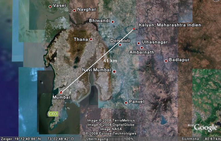
Abb.: Lage von Kalliena (= Kalyān/कल्याण)) und Souppara (= Sūpārā bei Vasaī/वसई)
[Bildquelle: ©Google Earth. -- Zugriff am 2008-04-20]
To take these emporia in detail. Akabarou cannot be identified. The reading is probably corrupt. Between the mouths of the Namados and those of the Goaris, Ptolemy interposes Nousaripa, Poulipoula, Ariakē Sadinōn, and Soupara. Nausaripa is Nausari, about 18 miles to the south of Surat, and Soupara is Sūpārā near Vasāï. Benfey, who takes it to be the name of a region and not of a city, regards it as the Ophir of the Bible -- called in the Septuagint Σωφηρα. Sōphir, it may be added, is the Coptic name for India. Kalliena is now Kalyāṇa near Bombay [which must have been an important place at an early date. It is named in the Kaṇheri Bauddha Cave Inscriptions]. It is mentioned by Kosmas (p. 337), who states that it produced copper and sesamum and other kinds of logs, and cloth for wearing apparel. The name Sandanes, that of the Prince who sent Greek ships which happened to put into its port under guard to Barugaza, is thought by Benfey to be a territorial title which indicated that he ruled over Ariakē of the Sandineis. [But the elder "Saraganes" probably indicates one of the great Śātakarṇi or Āndhrabhṛitya dynasty.] Ptolemy does not mention Kallienā, though he supplies the name of a place omitted in the Periplūs, namely Dounga (VII. i. 6) near the mouth of the river Bēnda.
53. After Kalliena other local marts occur [S. 129] Sēmulla, Mandagora, Palaipatmai, Melizeigara, Buzantion, Toparon, and Turannosboas. You come next to the islands called Sēsekreienai and the island [S. 130] of the Aigidioi and that of the Kaineitai, near what is called the Khersonēsos, places in which are pirates, and after this the island Leukē (or 'the White') . Then follow Naoura [S. 131] and Tundis , the first marts of Limurikē, and after these Mouziris and Nelkunda, the seats of Government.
(53) Sēmulla (in Ptolemy Timoula and Simulla) is identified by Yule with Cheṅval or Chaul, a seaport 23 miles south of Bombay ; [but Bhagvanlāl Indraji suggests Chimūla in Trombay island at the head of the Bombay harbour ; and this is curiously supported by one of the Kanheri inscriptions in which Chemūla is mentioned, apparently as a large city, like Supārā and Kalyāna, in the neighbourhood]. After Simulla Ptolemy mentions Hippokou a [possibly, as suggested by the same, a partial translation of Grhoḍabandar on the Choḍa nadi in the Ṭhaṅa strait] and Baltipatna as places still in Ariakē, but Mandagara Buzanteion, Khersonēsos, Armagara, the mouths of the river Nanagouna, and an emporium called Nitra, as belonging to the Pirate Coast which extended to Dimurikē, of which Tundis, he says, is the first city. Ptolemy therefore agrees with our author in assigning the Pirate Coast to the tract of country between Bombay and Goa, This coast continued to be infested with pirates till so late a period as the year 1765, when they were finally exterminated by the British arms. Mandagara and Palaipatma may have corresponded pretty nearly in situation with the towns of Rājapur and Bankut. Yule places them respectively at Bankut and Debal. Melizeigara (Milizēguris or Milizigēris of Ptolemy, VII. i. 95), Vincent identifies with Jaygaḍh or Sidē Jaygaḍh. The same place appears in Pliny as Sigerus (VI. xxvi. 100). Buzantium may be referred to about Vijayadrug or Esvantgadh,Toparon may be a corrupt reading for Togaron, and may perhaps therefore be Devagaḍh which lies a little beyond Vijayadrug. Turannosboas is not mentioned elsewhere, but it may have been, as Yule suggests, the Bandā or Tirakal river. Müller placed it at Acharē. The first island on this part of the coast is Sindhudrug near Mālwan,to which succeeds a group called the Burnt Islands, among which the Vingorla rocks are conspicuous. These are no doubt the Heptanēsia of Ptolemy (VII. i. 95), and probably the Sēsikrienai of the Periplūs. The island Aigidion called that of the Aigidii may be placed at Goa, [but Yule suggests Angediva south of Sadāśivagaḍh, in lat. 14°45' N., which is better] . Kaineiton may be the island of St. George.
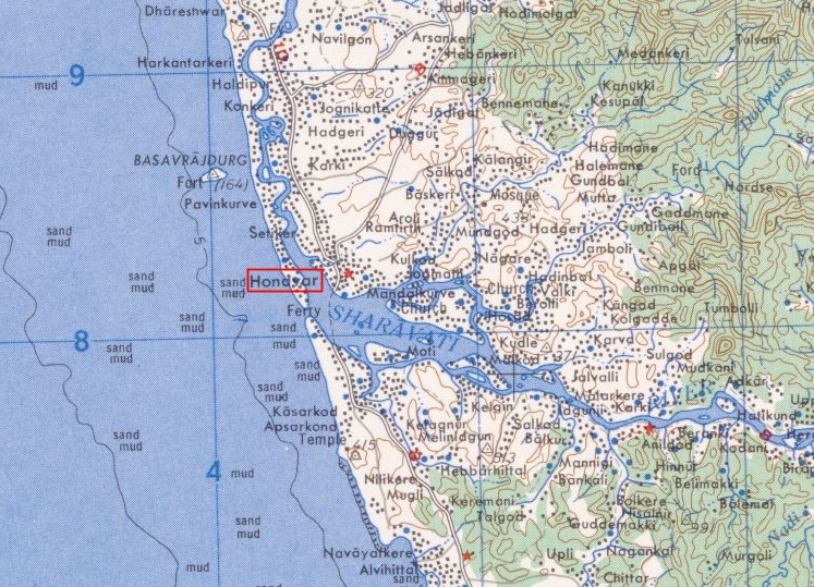
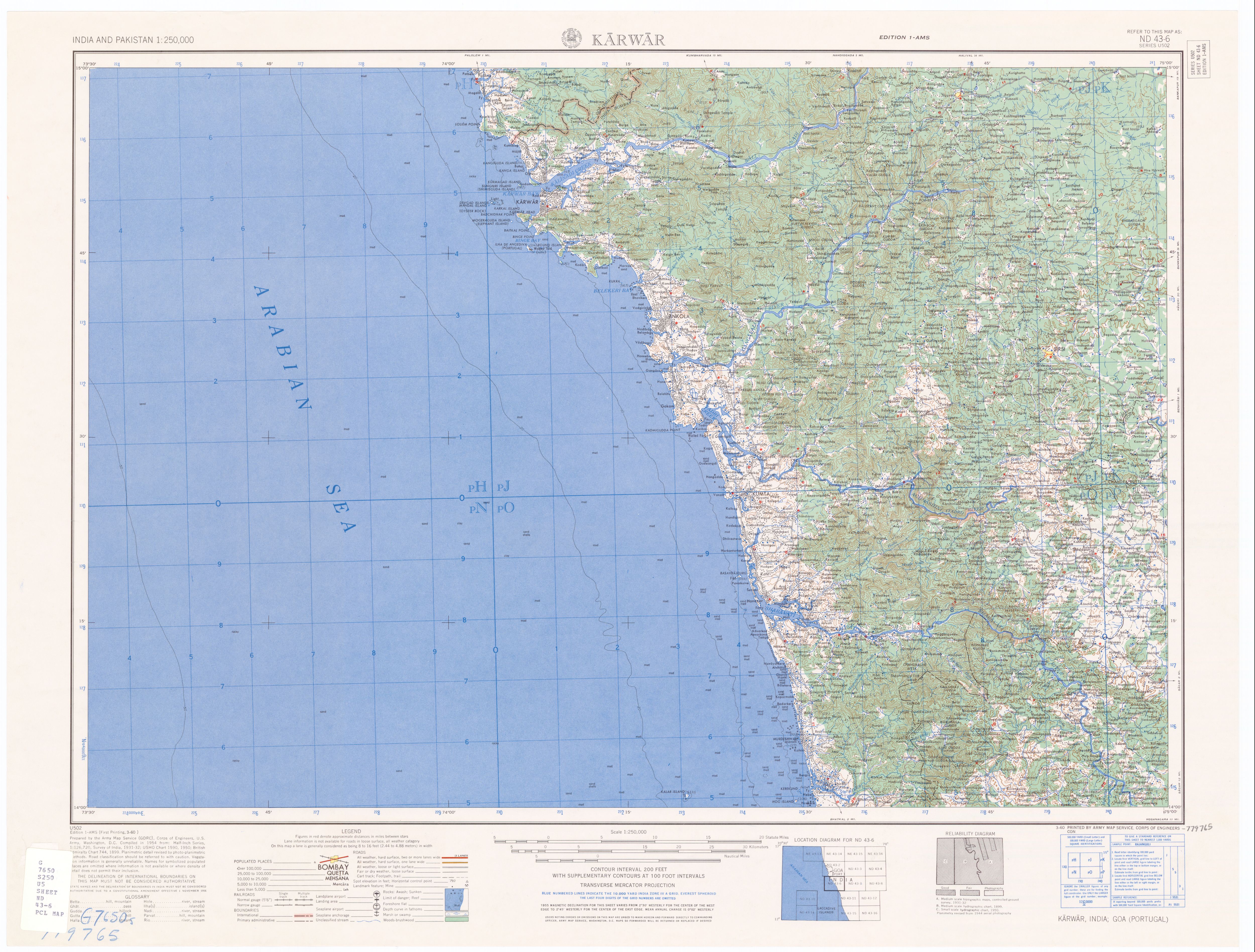
Abb.: Honāvar, Karnataka
[Bildquelle: US Army map. --
http://www.lib.utexas.edu/maps/ams/india/nd-43-06.jpg. -- Zugriff am
2008-04-20. -- Public domain]
We come next to Naoura in Dimurikē. This is now Honāvar, written otherwise Onore, situated on the estuary of a broad river, the Śarāvatī, on which are the falls of Gersappa, one of the most magnificent and stupendous cataracts in the world. If the Nitra of Ptolemy (VII. i. 7) and the Nitria of Pliny be the same as Naoura, then these authors extend the pirate coast a little further south than the Periplūs does. But if they do not, and therefore agree in their views as to where Dimurikē begins, the Nitra may be placed, Müller thinks, at Mirjan or Komta, which is not far north from Honavar. [Yule places it at Mangalur.] Müller regards the first supposition however as the more probable, and quotes at length a passage from Pliny (VI. xxvi. 104) referring thereto, which must have been excerpted from some Periplūs like our author's, but not from it as some have thought. "To those bound for India it is most convenient to depart from Okelis. They sail thence with the wind Hipalus in 40 days to the first emporium of India, Muziris, which is not a desirable place to arrive at on account of pirates infesting the neighbourhood, who hold a place called Nitrias, while it is not well supplied with merchandize. Besides, the station for ships is at a great distance from the shore, and cargoes have both to be landed and to be shipped by means of little boats. There reigned there when I wrote this Caelobothras. Another port belonging to the nation is more convenient, Neacyndon, which is called Becare (sic. codd., Barace, Harduin and Sillig). There reigned Pandion in an inland town far distant from the emporium called Modura. The region, however, from which they convey pepper to Becare in boats formed from single logs is Cottonara."
54. To the kingdom under the sway of [S. 132] Keprobotras Tundi is subject, a village of great note situate near the sea. Mouziris, which pertains to the same realm, is a city at the height of prosperity, frequented as it [S. 133] is by ships from Ariakē and Greek ships from Egypt. It lies near a river at a distance from Tundis of 500 stadia, whether this is measured from river to river or by the length of the sea [S. 134] voyage, and it is 20 stadia distant from the month of its own river. The distance of Nelkunda from Mouziris is also nearly 500 stadia, whether measured from river to river or [S. 135] by the sea voyage, but it belongs to a different kingdom, that of Pandion. It likewise is situate near a river and at about a distance from the sea of 120 stadia.
(54) With regard to the names in this extract which occur also in the Periplūs the following passages quoted from Dr. Caldwell's Dravidian Grammar will throw much light. He says (Introd. p 97): "Muziris appears to be the Muyiri of Muyiri-kotta. Tyndis is Tuṇḍi, and the Kynda, of Nelkynda, or as Ptolemy has it, Melkynda, i. e. probably Western kingdom, seems to be Kannettri, the southern boundary of Kerala proper. One MS. of Pliny writes the second part of this word not Cyndon but Canidon. The first of these places was identified by Dr. Gundert, for the remaining two we are indebted to Dr. Burnell.
"Cottonara, Pliny ; Kottonarike, Periplūs, the district where the best pepper was produced. It is singular that this district was not mentioned by Ptolemy. Cottonara was evidently the name of the district. κοττοναρικον the name of the pepper for which the district was famous. Dr. Buchanan identifies Cottonara with Kaḍattanaḍu, the name of a district in the Calicut country celebrated for its pepper. Dr. Burnell identifies it with Koḷatta-nāḍu, the district about Tellicherry which he says is the pepper district. Kadatta in Malayālam means 'transport, conveyance,' Nādū, Tam. Mal., means a district."
"The prince called Kērobothros by Ptolemy (VII. i. 86) is called Kēprobotros by the author of the Periplūs. The insertion of π is clearly an error, but more likely to be the error of a copyist than that of the author, who himself had visited the territories of the prince in question. He is called Caëlobothras in Pliny's text, but one of the MSS. gives it more correctly as Celobotras. The name in Sanskrit, and in full is 'Keralaputra,' but both kēra and kēla are Dravidian abbreviations of kēralā. They are Malayālam however, not Tamil abbreviations, and the district over which Keralaputra ruled is that in which the Malayālam language is now spoken" (p. 95). From Ptolemy we learn that the capital of this prince was Karoura, which has been "identified with Karūr, an important town in the Koimbatur district originally included in the Chera kingdom. Karūr means the black town . . Ptolemy's word Karoura represents the Tamil name of the place with perfect accuracy." Nelkunda, our author informs us, was not subject to this prince but to another called Pandion. This name, says Dr. Caldwell, "is of Sanskrit origin, and Pandae, the form which Pliny, after Megasthenes, gives in his list of the Indian nations, comes very near the Sanskrit. The more recent local information of Pliny himself, as well as the notices of Ptolemy and the Periplūs, supply us with the Dravidian form of the word. The Tamil sign of the masc. sing, is an, and Tamil inserts i euphonically after ṇḍ, consequently Pandion, and still better the plural form of the word Pandiones, faithfully represents the Tamil masc. sing. Pāṇḍiyan." In another passage the same scholar says : "The Sanskrit Paṇḍya is written in Tamil Pāṇḍiya, but the more completely tamilized form Pāṇḍi is still more commonly used all over southern India. I derive Pāṇḍi, as native scholars always derive the word, from the Sanskrit Pāṇḍu, the name of the father of the Pāṇḍava brothers." The capital of this prince, as Pliny has stated, was Modura, which is the Sanskrit Mathurā pronounced in the Tamil manner. The corresponding city in Northern India, Mathurā, is written by the Greeks Methora. Nelkunda is mentioned by various authors under varying forms of the name. As has been already stated, it is Melkunda in Ptolemy, who places it in the country of the Aii. In the Peutingerian Table it is Nincylda, and in the Geographer of Ravenna, Nilcinna. At the mouth of the river on which it stands was its shipping port Bakare or Becare, according to Mūller now represented by Markari (lat. 12° N.) Yule conjectures that it must have been between Kanetti and Kolum in Travancore. Regarding the trade of this place we may quote a remark from Vincent. "We find," he says, "that throughout the whole which the Periplūs mentions of India we have a catalogue of the exports and imports only at the two ports of Barugaza and Nelcynda, and there seems to be a distinction fixed between the articles appropriate to each. Fine muslins and ordinary cottons are the principal commodities of the first ; tortoise shell, precious stones, silk, and above all pepper, seem to have been procurable only at the latter. This pepper is said to be brought to this port from Cottonara, famous to this hour for producing the best pepper in the world except that of Sumatra. The pre-eminence of these two ports will account for the little that is said of the others by the author, and why he has left us so few characters by which we may distinguish one from another."
Our author on concluding his account of Nelkunda interrupts his narrative to relate the incidents of the important discovery of the monsoon made by that Columbus of antiquity Hippalus. This account, Vincent remarks, naturally excites a curiosity in the mind to enquire how it should happen that the monsoon should have been noticed by Nearkhos, and that from the time of his voyage for 300 years no one should have attempted a direct course till Hippalus ventured to commit himself to the ocean. He is of opinion that there was a direct passage by the monsoons both in going to and coming from India in use among the Arabians before the Greeks adopted it, and that Hippalus frequenting these seas as a pilot or merchant, had met with Indian or Arabian traders who made their voyages in a more compendious manner than the Greeks, and that he collected information from them which he had both the prudence and courage to adopt, just as Columbus, while owing much to his own nautical experience and fortitude was still under obligations to the Portuguese, who had been resolving the great problems in the art of navigation for almost a century previous to his expedition.
55. At the very mouth of this river lies [S. 136] another village, Bakarē, to which the ships despatched from Nelkunda come down empty and ride at anchor off shore while taking in cargo : for the river, it may be noted, has sunken reefs and shallows which make its navigation difficult. The sign by which those who come hither by sea know they are nearing land is their meeting with snakes, which are here of a black colour, not so long as those already mentioned, like serpents about the head, and with eyes the colour of blood.
(55) Nelkunda appears to have been the limit of our author's voyage along the coast of India, for in the sequel of his narrative he defines but vaguely the situation of the places which he notices, while his details are scanty, and sometimes grossly inaccurate. Thus he makes the Malabar Coast extend southwards beyond Cape Comorin as far at least as Kolkhoi (near Tutikorin) on the Coromandel coast, and like many ancient writers, represents Ceylon as stretching westward almost as far as Africa.
56. The ships which frequent these ports are of a large size, on account of the great amount and bulkiness of the pepper and betel of which their lading consists. The imports here are principally
Great quantities of specie.
(Topaz ?) Gold-stone, Chrysolite.
A small assortment of plain cloth.
Flowered robes.
Stibium, a pigment for the eyes1, coral.
White glass, copper or brass.
Tin, lead.
Wine but not much, but about as much as at Barugaza. [S. 137]
Sandarach (Sindūrā)2. .
Arsenic (Orpiment), yellow sulphuret of arsenic3.
Corn, only for the use of the ship's company, as the merchants do not sell it.
Erklärungen:
1 Kajal (काजल, kājal) / Khol: schwarze Augenschmike
2 Sandarak: Harz der Konifere, Sandarakbaum (Tetraclinis articulata), zum Räuchern verwendet
3 Orpiment: Arsen(III)-sulfid (As4S6): als Farbpigment (Rauschgelb, Königsgelb; die leuchtendste nicht-synthetische Gelbfarbe)
The following commodities are brought to it for export:
Pepper in great quantity, produced in only one of these marts, and called the pepper of Kottonara.
Pearls in great quantity and of superior quality.
Ivory.
Fine silks.
Spikenard1 from the Ganges.
Betel -- all brought from countries further east.
Transparent or precious stones of all sorts.
Diamonds.
Jacinths2 .
Tortoise-shell from the Golden Island, and another sort which is taken in the islands which lie off the coast of Limurikē.
Erklärungen:
1 Indische Narde / Nardenähre (Nardostachys jatamansi): aus der Wurzel werden kostbare Öle und Salben gewonnen.
The proper season to set sail from Egypt for [S. 138] this part of India is about the month of July that is, Epiphi.
57. The whole round of the voyage from Kanē and Eudaimon Arabia, which we have just described, used to be performed in small vessels which kept close to shore and followed its windings, but Hippalos was the pilot who first, by observing the bearings of the ports and the configuration of the sea, discovered the direct course across the ocean ; whence as, at the season when our own Etesians are blowing, a periodical wind from the ocean likewise blows in the Indian Sea, this wind, which is the south-west, is, it seems, called in these seas Hippalos [after the name of the pilot who first discovered the passage by means of it]. From the time of this discovery to the present day, merchants who sail for India either from Kanē, or, as others do, from Arōmata, if Limurikē be their destination, must often change their tack, but if they are bound for Barugaza and Skythi , they are not retarded for more than three days, after which, committing themselves to the monsoon which blows right in the direction of their course, they stand far out to sea, leaving all the gulfs we have mentioned in the distance.
[S. 139] 58. After Bakarē occurs the mountain called Pyrrhos (or the Red) towards the south, near another district of the country called Paralia (where the pearl-fisheries are which belong to king Pandion), and a city of the name of Kolkhoi, In this tract the first place met with is called Balita, which has a good harbour and a village on its shore. Next to this is another place called Komar, where is the cape of the same name and a haven. Those who wish to consecrate the closing part of their lives to religion come hither and bathe and engage themselves to celibacy. This is also done by women ; since it is related that the [S. 140] goddess (Kumārī) once on a time resided at the place and bathed. From Komarei (towards the south) the country extends as far as Kolkhoi, where the fishing for pearls is carried on. Condemned criminals are employed in this service. King Pandion is the owner of the fishery. To Kolkhoi succeeds another coast lying along a gulf having a district in the interior bearing the name of Argalou. In this single place are obtained the pearls collected near the island of Epiodōros. From it are exported the muslins called ebargareitides.
(58) The first place mentioned after Bakarē is Purrhos, or the Red Mountain, which extends along a district called Paralia. "There are," says Dr. Caldwell (Introd. p. 99), "three Paralias mentioned by the Greeks, two by Ptolemy . . . one by the author of the Periplūs. The Paralia mentioned by the latter corresponded to Ptolemy's country of the Αιοι, and that of the Καρεοι, that is, to South Travancore and South Tinnevelly. It commenced at the Red Cliffs south of Quilon, and included not only Cape Comorin but also Κολχοι, where the pearl fishing was carried on, which belonged to King Pandion. Dr. Burnell identifies Paralia with Parali, which he states is an old name for Travancore, but I am not quite able to adopt this view." "Paralia," he adds afterwards, "may possibly have corresponded in meaning, if not in sound, to some native word meaning coast, viz., Karei." On this coast is a place called Balita, which is perhaps the Bammala of Ptolemy (VII. i. 9), which Mannert identifies with Manpalli, a little north of Anjenga.
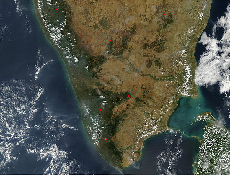
Abb.: Südindien
[Bildquelle: NASA/Wikipedia, Public domain]
60. Among the marts and anchorages along this shore to which merchants from Limurikē [S. 141] and the north resort, the most conspicuous are Kamara and Podoukē and Sōpatma, which occur in the order in which we have named them. In these marts are found those native vessels for coasting voyages which trade as far as Limurikē, and another kind called [S. 142] sangara, made by fastening together large vessels formed each of a single timber, and also others called kolandiophānta, which are of great bulk and employed for voyages to Khrusē and the Ganges. These marts import all the commodities which reach Limurikē for commercial [S. 143] purposes, absorbing likewise nearly every species of goods brought from Egypt, and most descriptions of all the goods exported from Limurikē and disposed of on this coast of India.
(60) We now reach the great promontory called in the Periplūs Komar and Komarei, Cape Kumari. "It has derived its name," says Caldwell, "from the Sans. Kumārī, a virgin, one of the names of the goddess Durgā, the presiding divinity of the place, but the shape which this word has taken is, especially in komar, distinctively Tamilian." In ordinary Tamil Kumārī becomes Kumări; and in the vulgar dialect of the people residing in the neighbourhood of the Cape a virgin is neither Kumārī nor Kumări but Kŭmăr pronounced Kŏmăr. It is remarkable that this vulgar corruption of the Sanskrit is identical with the name given to the place by the author of the Periplus . . . The monthly bathing in honor of the goddess Durgā is still continued at Cape Comorin, but is not practised to the same extent as in ancient times . . . Through the continued encroachments of the sea, the harbour the Greek mariners found at Cape Comorin and the fort (if (φρουριον is the correct reading for βριαριον of the MS.) have completely disappeared ; but a fresh water well remains in the centre of a rock, a little way out at sea. Regarding Kolkhoi, the next place mentioned after Komari, the same authority as we have seen places it (Ind. Ant. vol. VI. p. 80) near Tuticorin. It is mentioned by Ptolemy and in the Peutinger Tables, where it is called 'Colcis Indorum'. The Gulf of Manaar was called by the Greeks the Colchic Gulf. The Tamil name of the place Kolkei is almost identical with he Greek. "The place," according to Caldwell, "is now about three miles inland, but there are abundant traces of its having once stood on the coast, and I have found the tradition that it was once the seat of the pearl fishery, still surviving amongst its inhabitants. After the sea had retired from Κολχοι ... a new emporium arose on the coast. This was Kāyal, the Cael of Marco Polo. Kāyal in turn became in time too far from the sea . . and Tuticorin (Tūttrukuḍi) was raised instead by the Portuguese from the position of a fishing village to that of the most important port on the southern Coromandel coast. The identification of Kolkoi with Kolkei is one of much importance. Being perfectly certain it helps forward other identifications. KoL in Tamil means ' to slay.' Kei is ' hand.' It was the first capital of Pandion.
The coast beyond Kolkhoi, which has an inland district belonging to it called Argalou, is indented by a gulf called by Ptolemy the Argarik -- now Palk Bay. Ptolemy mentions also a promontory called Kōru and beyond it a city called Argeirou and an emporium called Salour. This Kōru of Ptolemy, Caldwell thinks, represents the Kōlis of the geographers who preceded him, and the Koṭi of Tamil, and identifies it with "the island promontory of Rāmeśvaram, the point of land from which there was always the nearest access from Southern India to Ceylon." An island occurs in these parts, called that of Epiodōros, noted for its pearl fishery, on which account Ritter would identify it with the island of Manaar, which Ptolemy, as Mannert thinks, speaks of as Νανιγερις (VII. i.95). Müller thinks, however, it may be compared with Ptolemy's Kōru, and so be Rāmeśvaram.
This coast has commercial intercourse not only with the Malabar ports, but also with the Ganges and the Golden Khersonese. For the trade with the former a species of canoes was used called Sangara. The Malayālam name of these, Caldwell says, is Changādam, in Tuḷu Jangāla, compare Sanskrit Samghādam a raft (Ind. Ant. vol. I. p. 309). The large vessels employed for the Eastern trade were called Kolandiophonta, a name which Caldwell confesses his inability to explain.
"Three cities and ports are named in the order of their occurrence which were of great commercial importance, Kamara, Podouke, andSopatma. Kamara may perhaps be, as Müller thinks, the emporium which Ptolemy calls Khabēris, situated at the mouth of the River Khabēros (now, the Kavery), perhaps, as Dr. Burriell suggests, the modern Kaveripattam. (Ind. Ant. vol. VII. p. 40). Pōdoukē appears in Ptolemy as Podoukē. It is Puduchcheri, i. e. 'new town,' now well known as Pondicherry ; so Bohlen, Ritter, and Benfey. [Yule and Lassen place it at Pulikāt] . Sopatma is not mentioned in Ptolemy, nor can it now be traced. In Sanskrit it transliterates into Su-patna, i. e., fair town.
61 . Near the region which succeeds, where [S. 144] the course of the voyage now bends to the east, there lies out in the open sea stretching towards the west the island now called Palaisimoundou, but by the ancients Taprobanē. To cross over to the northern side of it takes a day. In the south part it gradually stretches towards the west till it nearly reaches the opposite coast of Azania. It produces pearl, precious (transparent) stones, muslins, and tortoise-shell.
(61) The next place noticed is the Island of Ceylon, which is designated Palaisimoundou, with the remark that its former name was Taprobanē. This is the Greek transliteration of Tāmraparṇī, the name given by a band of colonists from Magadha to the place where they first landed in Ceylon, and which was afterwards extended to the whole island. It is singular, Dr. Caldwell remarks, that this is also the name of the principal river in Tinnevelly on the opposite coast of India, and he infers that the colony referred to might previously have formed a settlement in Tinnevelly at the mouth of the Tāmraparṇi river -- perhaps at Kolkei, the earliest residence of the Pāṇḍya kings. The passage in the Periplūs which refers to the island is very corrupt.
62. (Returning to the coast,) not far from the three marts we have mentioned lies Masalia, the seaboard of a country extending far inland. Here immense quantities of fine muslins are manufactured. From Masalia the course of the voyage lies eastward across a neighbouring bay to Dēsarēnē, which has the breed of elephants called Bōsarē. Leaving Desarēnē the course is northerly, passing a variety of barbarous tribes, among which are the Kirrhadai, savages whose noses are flattened to the face, and another tribe, that of the Bargusoi, [S. 146] as well as the Hippioprosōpoi or Makroprosōpoi (the horse faced or long faced men), who are reported to be cannibals.
(62) Recurring to the mainland, the narrative notices a district called Masalia, where great quantities of cotton were manufactured. This is the Maïsōlia of Ptolemy, the region in which he places the mouths of a river the Maisōlos, which Benfey identifies with the Godāvarī, in opposition to others who would make it the Krishnā, which is perhaps Ptolemy's Tuna. The [S. 145] name Maisōlia is taken from the Sanskrit Mausala, preserved in Machhlipatana, now Masulipatam. Beyond this, after an intervening gulf running eastward is crossed, another district occurs, Desarēnē, noted for its elephants. This is not mentioned by Ptolemy, but a river with a similar name, the Dōsarōn, is found in his enumeration of the rivers which occur between the Maisōlos and the Ganges. As it is the last in the list it may probably be, as Lassen supposes, the Brāhminī. Our author however places Desarēnē at a much greater distance from the Ganges, for he peoples the intermediate space with a variety of tribes which Ptolemy relegates to the East of the river. The first of these tribes is that of the Kirrādai (Sanskrit, Kirātas), whose features are of the Mongolian type. Next are the Bargusoi, not mentioned by Ptolemy, but perhaps to be identified with the cannibal race he speaks of, the Barousai thought by Yule to be possibly the inhabitants of the Nikobar islands, and lastly the tribe of the long or horse-faced men who were also cannibals.
63. After passing these the course turns again to the east, and if you sail with the ocean to your right and the coast far to your left, you reach the Ganges and the extremity of the continent towards the east called Khrusē (the Golden Khersonese). The river of this region called the Ganges is the largest in India ; it has an annual increase and decrease like the Nile, and there is on it a mart called after it, Gangē, through which passes a considerable traffic consisting of betel, the Gangetic spikenard, [S. 147] pearl, and the finest of all muslins those called the Gangetic. In this locality also there is said to be a gold mine and a gold coin called Kaltis. Near this river there is an island of the ocean called Khrusē (or the Golden), which lies directly under the rising sun and at the extremity of the world towards the east. It produces the finest tortoise-shell that is found throughout the whole of the Erythraean Sea,
(63) When this coast of savages and monsters is left behind, the course lies eastward, and leads to the Ganges, which is the greatest river of India, and adjoins the extremity of the Eastern continent called Khrusē, or the Golden. Near the river, or, according to Ptolemy, on the third of its mouths stands a great emporium of trade called Gangē, exporting Malabathrum and cottons and other commodities. Its exact position there are not sufficient data to determine. Khrusē is not only the name of the last part of the continent, but also of an island lying out in the ocean to eastward, not far from the Ganges. It is the last part of the world which is said to be inhabited. The situation of Khrusē is differently denned by different ancient authors. It was not known to the Alexandrine geographers. Pliny seems to have preserved the most ancient report circulated regarding it. He says (VI. xxiii. 80) : "Beyond the mouth of the Indus are Chrysē and Argyrē abounding in metals as I believe, for I can hardly credit what some have related that the soil consists of gold and silver." Mela (III. 7) assigns to it a very different position, asserting it to be near Tabis, the last spur of the range of Taurus. He therefore places it where Eratosthenes places Thinai, to the north of the Ganges on the confines of the Indian and Skythian oceans. Ptolemy, in whose time the Transgangetic world was better known, refers it to the peninsula of Malacca, the Golden Khersonese.
64. Beyond this region, immediately under the north, where the sea terminates outwards, there lies somewhere in Thīna a very great city, not on the coast, but in the interior of the country, called Thīna, from which silk, whether in the raw state or spun into thread [S. 148] and woven into cloth, [S. 148] is brought by land to Barugaza through Baktria, or by the Ganges to Limurikē. To penetrate into Thīna is not an easy undertaking, and but few merchants come from it, and that rarely. Its situation is under the Lesser Bear, and it is said to be conterminous with the remotest end of Pontos, and that part of the Kaspian Sea which adjoins the Maiōtic Lake, along with which it issues by one and the same mouth into the ocean.
(64) The last place which the Periplūs mentions is Thinai, an inland city of the Thinai or Sinai, having a large commerce in silk and woollen stuffs. The ancient writers are not at all agreed as to its position, Colonel Yule thinks it was probably the city described by Marco Polo under the name of Kenjan-fu (that is Singan-fu or Chauggan,) the most celebrated city in Chinese history, and the capital of several of the most potent dynasties. It was the metropolis of Shi Hwengti of the T'Sin dynasty, properly the first emperor, and whose conquests almost intersected those of his contemporary Ptolemy Euergetes -- (vide Yule's Travels of Marco Polo, vol. II. p. 21).
65. On the confines, however, of Thīnai an annual fair is held, attended by a race of men of squat figure, with their face very broad, but mild in disposition, called the Sēsatai, who in appearance resemble wild animals. They come with their wives and children to this fair, bringing heavy loads of goods wrapped up in mats resembling in outward appearance the early leaves of the vine. Their place of assembly is where their own territory borders with that of Thīnai ; and here, squatted on the mats on which [S. 149] they exhibit their wares, they feast for several days, after which they return to their homes in the interior. On observing their retreat the people of Thīnai, repairing to the spot, collect the mats on which they had been sitting, and taking out the fibres, which are called petroi, from the reeds, they put the leaves two and two together, and roll them up into slender balls, through which they pass the fibres extracted from the reeds. Three kinds of Malabathrum are thus made -- that of the large ball, that of the middle, and that of the small, according to the size of the leaf of which the balls are formed. Hence there are three kinds of Malabathrum, which after being made up are forwarded to India by the manufacturers.
66. All the regions beyond this are unexplored, being difficult of access by reason of the extreme rigour of the climate and the severe frosts, or perhaps because such is the will of the divine power.
Zu: Megasthenes (Μεγασθενής): Indika-fragments