Zitierweise / cite as:
Payer, Alois <1944 - >: Quellenkunde zur indischen Geschichte bis 1858. -- 16. Quellen aus der Zeit des British Raj. -- 4. Zum Beispiel: Mysore / The Imperial gazetteer of India, 1907 - 1909. -- Fassung vom 2008-06-23. -- http://www.payer.de/quellenkunde/quellen1604.htm
Erstmals publiziert als:
The Imperial gazetteer of India / published under the authority of His Majesty’s Secretary of State for India in Council. -- New ed. -- Oxford : Clarendon Press, 1907-1909. -- 25 Bde. ; 22 cm. -- Bd. 18. -- 1908. -- S. 161 - 261. -- Online: http://www.archive.org/details/imperialgazettee030583mbp. -- Zugriff am 2008-06-15
Abbildungen aus:
Thurston, Edgar <1855 - 1935>: The Madras presidency with Mysore, Coorg, and the associated states. -- Cambridge : University Press, 1913. -- xii, 293 S. : Ill. ; 23 cm. -- (Provincial geographies of India). -- Online: http://www.archive.org/details/provincialgeogra03holluoft. -- Zugriff am 2008-06-21. -- "Not in copyright."
Hodson, Thomas: Old Daniel or: Memoir of a converted Hindoo, with observations on the mission work in the Gobbe Circuit, and description of village life in India. -- London: Wesleyan Conference Office, [1877?]. -- Online: http://www.archive.org/details/olddanielormemoi00hodsiala. -- Zugriff am 2008-06-22. -- "Not in copyright."
Erstmals hier publiziert: 2008-06-23
Überarbeitungen:
Anlass: Lehrveranstaltung FS 2008
©opyright: Dieser Text steht der Allgemeinheit zur Verfügung. Eine Verwertung in Publikationen, die über übliche Zitate hinausgeht, bedarf der ausdrücklichen Genehmigung des Verfassers
Dieser Text ist Teil der Abteilung Sanskrit von Tüpfli's Global Village Library
Falls Sie die diakritischen Zeichen nicht dargestellt bekommen, installieren Sie eine Schrift mit Diakritika wie z.B. Tahoma.
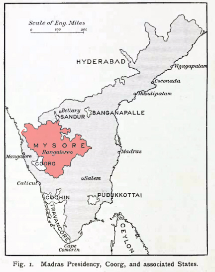
Abb.: Lage von Mysore
[Bildquelle: Thurston, Edgar <1855 - 1935>: The Madras presidency with Mysore, Coorg, and the associated states / Edgar Thurston. -- Cambridge : University Press, 1913. -- xii, 293 S. : Ill. ; 23 cm. -- (Provincial geographies of India). -- S. 2. -- Online: http://www.archive.org/details/provincialgeogra03holluoft. -- Zugriff am 2008-06-21. -- "Not in copyright."]
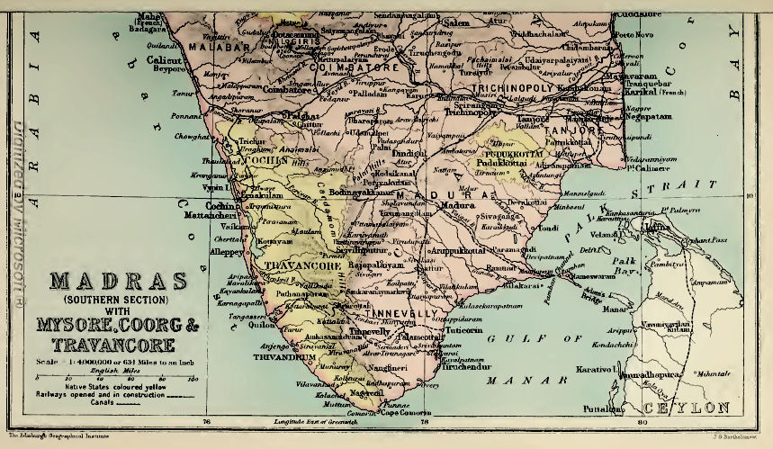
Abb.: Madras (Southern Section) with Mysore (ಮೈಸೂರು ಜಿಲ್ಲೆ), Coorg & Travancore
[a.a.O, nach S. 250]
Native State in Southern India, lying between 11° 36° and 15° 2' N. and 74° 38' and 78° 36'' E. It consists of an undulating table-land, much broken up by chains of rocky hills and scored by deep ravines.
Its form is that of a triangle, with the apex to the south, at the point where the Western and Eastern Ghāt ranges converge in the group of the Nīlgiris. The general elevation rises from about 2,000 feet above sea-level along the north and south frontiers to about 3,000 feet at the central water-parting which separates the basin of the Kistna to the north from that of the Cauvery to the south. This watershed divides the country into two nearly equal parts, a little north of lat. 13° and as far as long. 77°, where a transverse line marks the eastern watershed. Several chains of hills, running chiefly north and south, subdivide the whole into numerous valleys, widely differing in shape and size. Isolated peaks of massive rock, called 'droogs' (from Sanskrit durga, ' hill-fort '), rear their heads on all sides to an elevation of 4,000 or 5,000 feet above the level of the sea. The area of the State is 29,433 square miles. The greatest length north and south is about 230 miles; east and west about 290 miles. It is bounded by Madras Districts on all sides except on the north-west, where it is bordered by two Bombay Districts, and towards the southwest, where Coorg intervenes.
The name is that of the capital, Mysore, for Maisūr (from mahisha, Sanskrit for 'buffalo,' reduced in Kanarese to maisa, and ūru, Kanarese [S. 162] for 'town' or 'country'), which commemorates the destruction of Mahishāsura, a minotaur or buffalo-headed monster, by Chāmundi or Mahishāsura Mardanī, the form under which the consort of Siva is worshipped as the tutelary goddess of the ruling family. It is the Mahisa-mandala of Asoka's time, and forms the main part of the region called throughout Hindu literature Karnāta or Karnātaka, a term now wrongly applied to the districts below the Eastern Ghāts (see Carnatic).
Mysore is naturally divided into two regions of distinct character : the hill country, called the Malnād, on the west, confined to the tracts bordering or resting on the Western Ghāts (in Shimoga, Kadūr, and Hassan Districts) ; and the more open country in the east, known as the Maidān or Bayalshīme, comprising the greater part of the State, where the wide-spreading valleys and plains are occupied by numerous villages and populous towns. The Malnād is a picturesque land of mountain and forest, presenting the most diversified and beautiful scenery. The various parts of the Maidān take their character from the means of water-supply and the prevailing cultivation. The level plains of black soil, in the north, grow cotton or millets ; the tracts in the south and west, irrigated by channels drawn from rivers, are covered with plantations of sugar-cane and fields of rice; those irrigated from tanks have gardens of coco-nut and areca palms ; the wide tracts of red soil, in the east, yield rāgi and other 'dry crops'; the stony and wide-spreading pasture grounds, in the central parts of the country, are stretches of coarse grass, relieved by shady groves of trees.
From the massive group of the Nīlgiris, which command the southern frontier, stretch forth, north-west and north-east respectively, the Western and Eastern Ghāt ranges, between which the plateau of Mysore lies like a wedge. The hills within this table-land, though rarely in continuous connected chains, arrange themselves into systems crossing the country longitudinally, in directions more or less parallel to the Ghāt ranges, according to their proximity to one or the other. They attain their greatest elevation somewhat north of lat. 13°, where Mulainagiri (the highest point in Mysore), in the Bābā Budans, in the west, rises to 6,317 feet, and Nandidroog, in the east, to 4,851 feet. The best defined of the interior ranges is a belt, from 10 to 20 miles wide, running between 77° and 77° 30' E., from the Biligiri-Rangans (4,195 feet), through Sāvandurga (4,024) and Sivaganga (4,559), north up to Maddagiri (3,935), and on by Nidugal (3,772) to Molakālmuru and the frontier. In the west a corresponding range, not more than 10 miles in width, runs north along meridian 75° 30' E., from Ballālrāyandurga (4,940 feet) beyond Shikārpur, having on its east the big loop of the Bābā Budans, whose peaks rise to over 6,000 feet. [S. 163] Intermediate between these two internal ranges is a chain, with considerable intervals between its component parts, trending to the east on the south of the central watershed, and to the west on the north of it. Starting from the Wynaad frontier at Gopālswāmi Betta (4,770 feet), it passes by Nāgamangala to Chunchangiri (3,221), reappears to the west of Kibbanhalli in the Hāgalvādi hills (3,543), and crosses in a continuous belt through the middle of Chitaldroog District. Of minor ranges the most important is that of Nandidroog, commencing near the hill of that name, with several peaks of nearly equal height, and passing north by Gudibanda to the Anantapur country. In the west a similar medial chain, but of lower elevation, runs from east of the Bābā Budans through Sakunagiri (4,653 feet), by the Ubrāni hills and Basavāpatna, along the right bank of the Tungabhadra to the frontier, where it meets that river.
The drainage of the country, with a slight exception, finds its way east to the Bay of Bengal, and is divisible into three great river systems : that of the Kistna on the north, the Cauvery on the south, and the Penner, Ponnayār, and Pālār on the east. The only streams flowing west to the Arabian Sea are those in the northwest, which, uniting in the Sharāvatī, hurl themselves down the Ghāts in the magnificent Gersoppa Falls ; and some minor streams which run down to South Kanara. A line drawn east from Ballālrāyandurga to Nandidroog, and thence south to Anekal, with one from Devarāyadurga north to Pāvugada, will indicate approximately the watershed separating the three main river basins. From the north of this ridge flow the Tunga and Bhadra, rising in the Western Ghāts and uniting in the Tungabhadra, which, after receiving the Hagari or Vedāvati, joins the Kistna beyond the limits of Mysore near Kurnool. From the south, the Hemāvati (tributary the Yagachi), the Lokapāvani, Shimsha, and Arkāvati flow into the Cauvery, which rises in Coorg and takes a south-easterly course through the State, receiving also from the south the Lakshmantīrtha, the Kabbani or Kapila (tributaries the Nugu and Gundal), and the Honnuhole or Suvarnāvati. From the east of the watershed, in the immediate neighbourhood of Nandidroog, spring three main streams : namely, the Uttara Pinakīni or Penner (tributaries the Chitrāvati and Pāpaghni), which runs into the sea at Nellore ; the Dakshina Pinakīni or Ponnayār, which reaches the sea at Cuddalore ; and between them the Pālār, whose mouth is at Sadras.
Owing to either rocky or shallow beds, none of these rivers is navigable in Mysore ; but timber is floated down the Tunga, the Bhadra, and the Kabbani at certain seasons. Most of the streams are fordable during the dry months, but during floods traffic over them is often suspended until the water subsides. Though useless [S. 164] for navigation, the main streams, especially the Cauvery and its tributaries, support an extensive system of irrigation by means of channels drawn from immense dams, called 'anicuts,' which retain the upper waters at a high level and permit only the overflow to pass down stream. The channels or halves drawn from them meander over the country on either bank, following all the sinuosities of the ground, the total length maintained being upwards of 1,200 miles.
There are no natural lakes in Mysore ; but the streams which gather from the hill-sides and fertilize the valleys are embanked at every favourable point in such a manner as to form series or chains of reservoirs called tanks (Kanarese, kere), the outflow from one at a higher level supplying the next lower, and so on all down the course of the stream at a few miles apart. These tanks, varying in size from small ponds to extensive lakes, are dispersed throughout the country to the number of nearly 30,000. The largest, Sūlekere, is 40 miles in circumference, but the Māri Kanave reservoir will exceed 90 miles. In the north-east are the spring-heads called talpargi, extending east of a line from Kortagere to Molakālmuru.
1Granites and granitic gneisses, regarded as of Archaean age, occupy the greater portion of the State, and traversing these are metamorphic schists of Pre-Palaeozoic age. There are besides,
more recent acid, basic, and ultra-basic dikes, penetrating both the former systems, and irrupted probably not later than Lower Palaeozoic times ;
a deposit of laterite, widely distributed in extensive sheets or oftener in small isolated patches, forming an almost horizontal capping on the denuded surfaces of the older rocks ;
some relatively unimportant alluvial and sub-aerial deposits.
The schistose rocks which traverse the great complex of granite and granitic gneiss, and are more or less folded down into it, form three well-marked bands running in a generally north and south direction. Two are of large size, and are known respectively as the Shimoga and Chiknāyakanhalli bands, from their proximity to those towns. The third is the Kolār band, very small in extent, but of the greatest economic importance. The two first named are southward extensions of the great bands in Dhārwār and Bellary2. The third is apparently an extension of a band running south along the Kadiri valley in Cuddapah, but a break of several miles appears to separate the two near the boundary line between Cuddapah and Mysore. [S. 165]
1 The earliest account of the geology of Mysore was by Captain Newbold in 1844-50 (see articles on the ' Geology of Southern India,' J.R. A. S., vols, viii, ix, xii). A State Geological department was formed under Mr. Bruce Foote in 1894, and is now under Dr. W. F. Smeeth, on whose notes this section is based.
2 See Bruce Foote's 'Geological Features of the South Mahratta Country,' 'Geology of the Bellary District,' and other papers (Memoirs, Geographical Survey of India, vols, xii, xxv; and Records, Geographical Survey of India, vols, xv, xxi, xxii).
The Shimoga band crosses the Tungabhadra near Harihar, extends to the southern boundary of Kadūr District, and spreads from near Kadūr on the east to the edge of the Western Ghāts on the west, where it forms much of the high Ghāt country culminating in the Kudremukh at an elevation of 6,215 feet. From this point the western boundary is probably continuous up to Anantapur (Shimoga District). West of Anantapur the country is covered by a great spread of laterite, beneath which gneiss is exposed in deep nullahs. The Chiknāyakanhalli band runs through the middle of the State in a north-north-west and south-south-east direction. At the northern boundary it is divided into two horns by the great granite massif of Chitaldroog. Thence it runs south-south-west as far as Turuvekere n Tumkūr District, with an average width of about 18 miles. Here it suddenly pinches ; and the only continuous extension southward is a narrow band, with an average width of 2 to 3 miles, running from Baichihalli to the Karigatta hill, north of the Cauvery, opposite the east end of the island of Seringapatam. A little to the west of this narrow band are several small strings of schist near Myasandra, Nelligere, and Nāgamangala, some of which appear to be dikes1. An important schist belt lying throughout the east of this band has been discovered, the rocks of which resemble those of the Kolār band. The southern extension towards Sivasamudram is rock containing 50 per cent. of iron.
The Kolār band lies on the eastern side of the State. It extends north and south for a distance of 40 miles, with a maximum width of 4 miles, while three narrow strings extend southwards into North Arcot and Salem. In general outline the main portion of the band may be regarded as consisting of a southern portion about 12 miles long by 4 miles wide, in which the present Kolār Gold Field is situated ; a northern portion about 12 miles long by 5 miles wide ; and a narrow neck of schist about 10 miles long by i mile wide, connecting these two parts. The band is composed essentially of hornblendic rocks, usually schistose, and some well-marked layers of ferruginous quartz rocks.
1 See Mysore Geological Department Records, vol. iii, plate i ; vol. ii, p. 82 ; vol. iii, p. 113.
Granite exists in large irruptive masses, which have broken up and penetrated the older gneisses and schists. The gneisses so largely developed in Mysore are for the most part rocks of granitic composition, having a parallel-banded, wavy, or whorl-like structure, due to the arrangement of the lighter and darker constituents in more or less distinct bands or streaks. They appear to be of igneous origin, rather than metamorphosed sedimentary rocks as suggested by Mr. Bruce Foote, the banding being due partly to segregation [S. 166] of the more basic constituents, and partly to the contemporaneous or subsequent veining by pegmatite, aplite, and other forms of granitic material. The prevailing type is a biotite-gneiss.
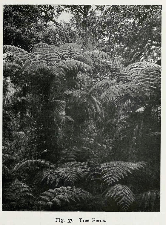
Abb.: Baumfarne
[Bildquelle: Thurston, Edgar <1855 - 1935>: The Madras presidency with Mysore, Coorg, and the associated states / Edgar Thurston. -- Cambridge : University Press, 1913. -- xii, 293 S. : Ill. ; 23 cm. -- (Provincial geographies of India). -- S. 105. -- Online: http://www.archive.org/details/provincialgeogra03holluoft. -- Zugriff am 2008-06-21. -- "Not in copyright."]
The Malnād or eastern face of the Western Ghāts is clothed with magnificent timber and contains the richest flora. The summits of the mountains are bare of trees, but covered with grasses and herbs—Anthisteria, Andropogon, Habenaria, &c. The valleys descending from them are filled with woods called sholas, leaving grass-covered ridges between. Above 4,500 feet is the evergreen belt; lower down, to 3,000 feet, is a mixed belt, practically continuous ; and finally the deciduous trees are at the foot and throughout the plains. At extreme heights occur trees of the Nīlgiri flora, but smaller. The South Indian tree-fern often ascends into the highest sholas, but rarer ferns abound in the mixed zone. It is here that coffee (Coffea arabica), pepper (Piper nigrum), and cardamoms (Elettaria cardamomum) are cultivated. Calophyllum tomentosum, Hardivickia binata, Bombax malabaricum, Vateria indica, Mesua ferrea, Myristica laurifolia, M. magnifica, Lagerstroemia lanceolata, L. Flos Reginae, Michelia Champaca, Ficus of many species, and Tectona grandis are some of the prominent trees in this belt, with the prickly bamboo (Bambusa arundinacea). The Maidān or open plateau contains numerous species not found in the upper hill region. Bassia latifolia, Pterocarpus santalinus, Tamarindus indicus, Feronia elephantum, Mangifera indica, Artocarpus integrifolia, Acacia arabica, Pongamia glabra, Santalum album. Phoenix sylvestris, and Cocos nucifera are some of those characteristic of this part. The hill ranges here and extensive areas in the plains are covered with small trees, shrubs, and twiners of various species, forming what is called scrub jungle. The main roads are lined with avenues of indigenous trees and the railroads with hedges of the aloe (Agave americana). Most villages have a grove (called a 'tope ') of common trees.
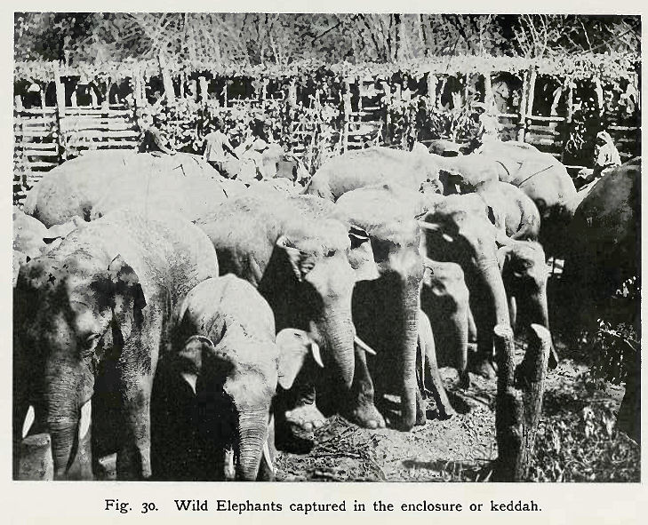
Abb.: Elefanten, in Keddah gefangen
[Bildquelle: Thurston, Edgar <1855 - 1935>: The Madras presidency with Mysore, Coorg, and the associated states / Edgar Thurston. -- Cambridge : University Press, 1913. -- xii, 293 S. : Ill. ; 23 cm. -- (Provincial geographies of India). -- S. 89. -- Online: http://www.archive.org/details/provincialgeogra03holluoft. -- Zugriff am 2008-06-21. -- "Not in copyright."]
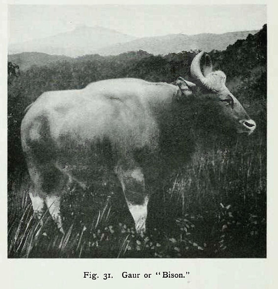
Abb.: Gaur (Fälschlich "Bison" genannt)
[Bildquelle: Thurston, Edgar <1855 - 1935>: The Madras presidency with Mysore, Coorg, and the associated states / Edgar Thurston. -- Cambridge : University Press, 1913. -- xii, 293 S. : Ill. ; 23 cm. -- (Provincial geographies of India). -- S. 90. -- Online: http://www.archive.org/details/provincialgeogra03holluoft. -- Zugriff am 2008-06-21. -- "Not in copyright."]
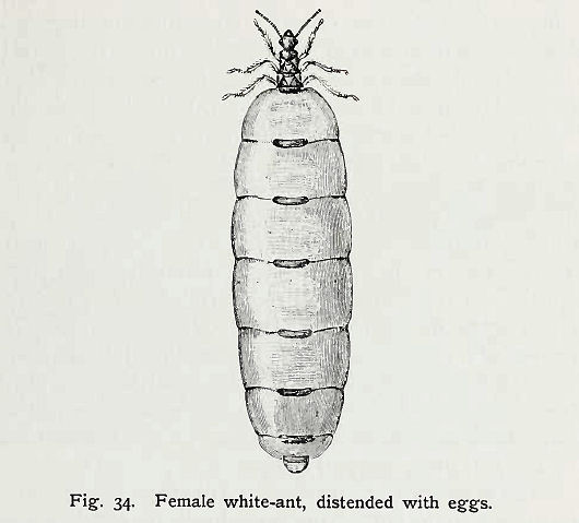
Elephants range through the southern forests and are also found in Shimoga District. A special Khedda department for their capture and training was formed in 1873, but was in abeyance from the famine of 1876 until 1889, when it was again in operation till 1898. Tigers, leopards, and bears are numerous. Bison are found in the western and southern forests. Various kinds of antelope and deer, wild hog, wolf, and wild dog are met with in different parts. Monkeys abound, and the southern langūr frequents the western woods. Otters and pangolins may also be mentioned. Among birds, peafowl are common in the west ; pelicans are also found, with numerous game-birds. Jays, parrots, kingfishers, orioles, and other birds of gay plumage are common. So are vultures, with many kinds of kites, hawks, and crows, as well as owls of various kinds. Of reptiles, the hamadryad is met with in remote and dense forests. Cobras, pythons, the karait, the rat snake [S. 167] or dhāmin the green snake, and others are general in all parts. Iguanas and chameleons may often be seen, while large lizards called 'bloodsuckers' are universal. Crocodiles abound in most of the western rivers, where mahseer and other large fish are also to be found. Of insects, leeches are common in the forests in the wet season, and are very troublesome. The lac insect propagates on the jālāri tree. Bees of many kinds are common. A small fly, not bigger than a flea, called the eye-fly or mango-fly, is quite a pest, especially in the mango season, and spreads ophthalmia. Mosquitoes are universal, and white ants or termites insatiable in their ravages. There is a great variety of mantis, some of which simulate straws or leaves.
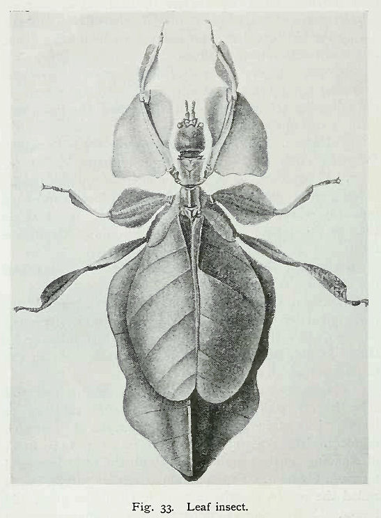
Abb.: Leaf insect (Gottesanbeterin)
[Bildquelle: Thurston, Edgar <1855 - 1935>: The Madras presidency with Mysore, Coorg, and the associated states / Edgar Thurston. -- Cambridge : University Press, 1913. -- xii, 293 S. : Ill. ; 23 cm. -- (Provincial geographies of India). -- S. 98. -- Online: http://www.archive.org/details/provincialgeogra03holluoft. -- Zugriff am 2008-06-21. -- "Not in copyright."]
Abb.: Termite[Bildquelle: Thurston, Edgar <1855 - 1935>: The Madras presidency with Mysore, Coorg, and the associated states / Edgar Thurston. -- Cambridge : University Press, 1913. -- xii, 293 S. : Ill. ; 23 cm. -- (Provincial geographies of India). -- S. 99. -- Online: http://www.archive.org/details/provincialgeogra03holluoft. -- Zugriff am 2008-06-21. -- "Not in copyright."]
The year in Mysore may be divided into three seasons : the rainy, the cold, and the hot. The first commences with the bursting of the south-west monsoon, generally early in June, and continues, with some interval in August and September, to the middle of November, closing with the heavy rains of what is popularly called the north-east monsoon. It is followed by the cold season, which is generally entirely free from rain, and lasts till the end of February. The hot season then sets in during March, and increases in intensity to the end of May, with occasional relief from thunderstorms. The temperature is most agreeable during the rainy months, the range of the thermometer at Bangalore at that season being between 64° and 84°. In the cold season the mercury falls there as low as 51° in the early morning, and sometimes rises to 80° during the day. The minimum and maximum in the shade during the hottest months are about 66° and 91°, or in extreme seasons 96°.
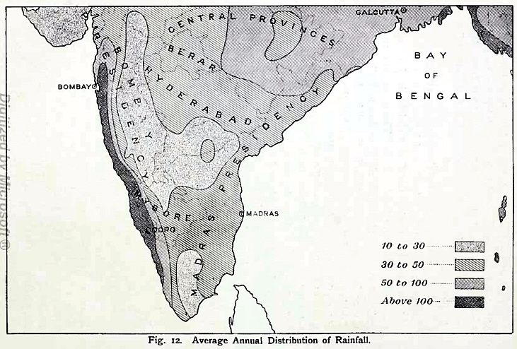
Abb.: Average annual distribution of rainfall
[Bildquelle: Thurston, Edgar <1855 - 1935>: The Madras presidency with Mysore, Coorg, and the associated states / Edgar Thurston. -- Cambridge : University Press, 1913. -- xii, 293 S. : Ill. ; 23 cm. -- (Provincial geographies of India). -- S. 48. -- Online: http://www.archive.org/details/provincialgeogra03holluoft. -- Zugriff am 2008-06-21. -- "Not in copyright."]
The annual rainfall ranges from over 360 inches on the crest of the Western Ghāts to as little as 19 inches in the north centre. But these are extremes that apply only to limited areas. The excessive rain of the Malnād rapidly diminishes eastwards, and from 20 to 37 inches may be accepted as the general annual average for the greater part of the State1. The zone of heavy rain, 60 inches and over, is confined to the Western Ghāt region from Sorab to Manjarābād. From 40 to 60 inches of rain fall between Sorab and Shikārpur, in the Bābā Budans region, and in Heggadadevankote. The zone of 25 to 40 inches extends over all the remainder of the State, except Chitaldroog District, the north of Tumkūr and Kolār Districts, and the extreme south-east of Mysore District, which have less than 25 inches. The distribution closely follows that of the forest belts, the heaviest rain coinciding with the evergreen belt, the next with the deciduous forest, and the least rainy tracts with the dry belt. [S. 168]
1 The mean annnal relative humidity of the Mysore State is set down by Mr. H. F. Blanford as 66. that of Malabar and Coorg being 79, and of the Carnatic 67. (Climates and Weather of India.)
The cold-season rains, December to March, are insignificant, scanty, and not much needed for the standing crops. But they are useful in keeping up the pasture supply. The hot-season rains, in April and May, sometimes called mango showers, are of the accidental kind, and give heavy short storms from the east. They are very important for agriculture, as a copious fail replenishes the tanks, and enables the cultivators to prepare the land for the ensuing monsoon. The southwest monsoon from June to September is perhaps the most essential for the country, which requires the steady drizzling rains of this season to make the soil productive. The north-east monsoon in October and November is essentially important for filling the tanks, and providing a store of water that may last over the rainless months.
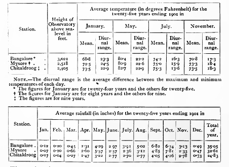
A Meteorological department was formed in 1893, with observatories at Bangalore, Mysore, Hassan, and Chitaldroog, and having under its direction 203 rain-gauge stations. The following table shows the average temperature and rainfall recorded at Bangalore, Mysore, and Chitaldroog for a period of years prior to 1901 :—
The authentic history of Mysore, like that of India in general, begins after the invasion by Alexander the Great in 327 B.C. and has been gathered from the inscriptions, several thousands in number, scattered all over the country1. On the retirement of Alexander, the north of India came under the dominion of Chandra Gupta, the first of the Maurya emperors, with his capital [S. 169]
1 These have been published by Mr. L. Rice, C.I.E., the Mysore Director of Archaeology, in a series called Epigraphia Canatica, numbering twelve volumes.
at Pātalīputra (Patna on the Ganges). According to the Jain traditions, supported by inscriptions and monuments, Chandra Gupta ended his days at Sravana Belgola in Mysore. In accordance with the dictates of the Jain religion, he gave up his throne in order to close his life in religious exercises, and accompanied the great teacher Bhadrabāhu on the migration which he led to the South from Ujjain, at the beginning of a twelve years' famine which he had predicted. When they reached Sravana Belgola, Bhadrabāhu felt his end approaching, and sent on the body of pilgrims under Visākha to the Punnāta country, the south-western portion of Mysore, he himself remaining behind, tended by a single disciple, who was no other than Chandra Gupta. There he died, and Chandra Gupta also, after surviving his teacher twelve years. Whatever truth there may be in this story, the discovery by Mr. Rice of edicts of Asoka in the north-east of the Mysore country has put it beyond doubt that that portion of the State formed part of the Maurya empire. Asoka also sent missionaries, among other places, to Mahisa-mandala (Mysore) and Vanavāsi (Banavāsi, north-west of the State). These were probably just beyond the limits of his empire.
The north of Mysore next came under the rule of the Andhra or Sātavāhana dynasty. From the latter name is derived the form Sālivāhana, applied to an era, dating from A. D. 78, which is in common use. Their period extends from the second century B. C. to the second century A. D., and their dominions stretched from east to west over the entire Deccan. Their chief capital was Dhanakataka (Dhāranikotta on the Kistna), but they had a western capital at Paithan on the Godāvari. The kings who ruled in Mysore bore the general name Sātakarni.
The Andhras were succeeded by the Kadambas on the north-west, and by the Pallavas in the north-east. The former were of indigenous origin, their birthplace being Sthānagundūr (Tālagunda in the Shikārpur tāluk). Banavāsi was their capital, and Shimoga District a part of their kingdom. The Pallavas had Kānchi (Conjeeveram) as their capital, and Tundāka or Tonda-mandala (the Madras country east of Mysore) as their territory, and displaced the Mahāvalis or Bānas, claiming descent from Bali or Mahā Bali, apparently connected with Mahābalipur (the Seven Pagodas, on the Madras coast). From the ninth century the Pallavas are also called Nonambas or Nolambas, and gave their name to Nonambavādi or Nolambavādi (Chitaldroog District), the inhabitants of which are represented by the existing Nonabas.
Meanwhile two Ganga princes from the north, of the Ikshvāku and therefore Solar race, named Dadiga and Mādhava, aided by the Jain priest Simhanandi, whom they met at Perūr (still called Ganga-Perūr, in Cuddapah), established themselves towards the close of the second [S. 170] century throughout the remaining parts of the Mysore country, with Kuvalāla or Kolāla (Kolār) as their chief city, and Nandagiri (Nandidroog) as their stronghold, founding the Gangavādi kingdom, whose inhabitants survive in the existing Gangadikāras. The name of this dynasty, which ruled in Mysore till the opening of the eleventh century, connects them with the Gangas or Gangaridae, the people of the Ganges valley, who according to Greek and Roman writers were the chief subjects of Chandra Gupta. The Gangas also founded dynasties in Kalinga (Orissa and adjacent parts), and are mentioned by Pliny as Gangaridae Calingae. It was remorse for the slaughter and devastation that attended his conquest of Kalinga which led Asoka to devote himself to peace and religion, as stated in his thirteenth Rock Edict. The boundaries of Gangavādi are given as : north, Marandale (not identified) ; east, Tonda-nād ; west, the ocean in the direction of Chera (Cochin and Travancore) ; south, Kongu (Salem and Coimbatore). All the kings had the cognomen Kongunivarma. The third king removed his capital to Talakād on the Cauvery. The seventh king, Durvinīta, made extensive conquests in the south and east, capturing some of the Pallava possessions. In the middle of the eighth century the Ganga dominion was in a high state of prosperity, and was designated the Srīrājya or 'fortunate kingdom.' The king Srīpurusha subdued the Pallavas and took from them the title of Permmanadi, always applied to the subsequent Ganga kings. He fixed the royal residence at Mānyapura (Manne in Bangalore District).
To revert to the north-west of the country. In the fifth century the Chālukyas, claiming to come from Ajodhyā, appeared in the Deccan and overcame the Rāshtrakūtas, but were stopped by the Pallavas. In the sixth century the Chālukya king Pulikesin wrested Vātāpi (Bādāmi in Bijāpur District) from the Pallavas and made it his capital. His son subdued the Mauryas ruling in the Konkan, and the Kadambas of Banavāsi. Another son conquered the Kalachuris also. Pulikesin II, in the seventh century, came into contact with the Gangas. About 617 the Chālukyas separated into two branches. The Eastern Chālukyas made Vengi (in Kistna District), taken from the Pallavas, and subsequently Rājahmundry, their capital, while the Western Chālukyas continued to rule from Vātāpi, and eventually from Kalyāni (in the Nizām's Dominions). These are styled the Satyāsraya family, from a name of Pulikesin, the first king of this branch, who was a great conqueror. His chief victory was over Harshavardhana, king of Kanauj, the most powerful monarch in Northern India. By this conquest he gained the title of Paramesvara. Both kings are described by the Chinese pilgrim Hiuen Tsiang. Pulikesin exchanged presents with Khusrū II of Persia. After his death the Pallavas inflicted severe losses on the Western Chālukyas, but Vikramāditya [S. 171] restored their power. He subdued the Pāndya, Chola, Kerala, and Kalabhra kings, and captured Kānchi, forcing the Pallava king, who had never bowed to any man, to place his crown at his feet. The three next kings followed up these victories, until all the powers from the Guptas on the Ganges to the southernmost rulers of Ceylon had submitted to them.
But the Rāshtrakūtas, under their kings Dantidurga and Krishna or Kannara, now succeeded in freeing themselves, and for 200 years from the middle of the eighth century became supreme. They were also called Rattas, and their territory Rattavādi. Their capital, at first Mayūrakhandi (Morkhand in Nasik District), was early in the ninth century at Mānyakheta (Mālkhed in the Nizām's Dominions). They commonly bore the title Vallabha, taken from the Chālukyas, which, in its Prākrit form Ballaha, led to their being called Balharās by Arab travellers of the tenth century. At the end of the eighth century Dhruva or Dhārāvarsha made the Pallava king pay tribute, and defeated and imprisoned the king of the Gangas, who had never been conquered before. During the interregnum thus caused, Rāshtrakūta viceroys governed the Ganga territories, of whom inscriptions tell us of Kambharasa, surnamed Ranāvaloka, apparently a son of Dhārāvarsha, and in 813 Chāki Rājā. Eventually the Rāshtrakūta king Govinda or Prabhūtavarsha released the Ganga king, probably Sivamāra, and replaced him on the throne. Nripatunga or Amoghavarsha had a very long reign during the ninth century, and has left writings in the Kanarese language which show his great interest in the people and country of Karnātaka1. His successor was engaged in constant wars with the Eastern Chālukyas. These were subdued in the middle of the tenth century by the Cholas, who thus came into collision with the Rāshtrakūtas, then in intimate alliance with the Gangas. Būtuga of the latter family had married a Rāshtrakūta princess, and helped his brother-in-law Kannara or Akālavarsha to secure the throne. He now rendered him a great service by slaying Rājāditya, the Chola king, at Takkola (near Arkonam). This put a stop to the Chola invasion ; and Būtuga was rewarded with the north-western districts of Mysore, in addition to those in the Bombay country which formed the dowry of his bride. In 973 Taila restored the supremacy of the Western Chālukyas, and Indra, the last of the Rāshtrakūtas, died at Sravana Belgola in 982.
1 A small Sanskrit work by him on morality was translated into Tibetan.
From the time of Rāchamalla, about 820, the Gangas had again prospered, and all the kings to the end take the title Satyavākya in addition to Permmanadi. Rachamalla was followed by Nītimārga, and he by Satyavākya and Ereyappa. Then came Būtuga, already mentioned. His successor, Mārasimha, utterly destroyed the Nolambas. [S. 172] With Rakkasa Ganga and a Nītimārga or Ganga Rājā the dynasty came to an end, in the manner related below.
The revival of the Western Chālukya power continued for 200 years, during the first half of which they were engaged in continual wars with the Cholas. The latter had from 972 completely subjugated the Eastern Chālukyas of Vengi, whose kingdom was eventually made an apanage of the Chola empire, being ruled by Chola princes as viceroys. At the same time a Chola princess was married to the Kalinga Ganga king still farther north. In 997 the Cholas under Rājarājā had invaded Mysore in the east. In 1004 they reappeared in overwhelming force, under his son Rājendra Chola, took Talakād, and subverted the Ganga sovereignty, capturing all the south and east of the country, up to a line from about Arkalgud through Seringapatam and Nelamangala to Nidugal.
The remaining portions of Mysore, that is, the north and west, were subject to the Western Chālukyas, of whom the most celebrated was Vikramāditya, the son of a Ganga mother, who ruled from 1076 to 1126. Their empire is generally called Kuntala, of which the Banavāse-nād, or Shimoga District, was a principal province. The capital of this was Balligāve, now Belgāmi in the Shikārpur tāluk, which contained splendid temples, dedicated to Jina, Buddha, Vishnu, Siva, and Brahmā. Famous scholars were at the head of its five maths, where, as in the mediaeval monasteries of Europe, food and medicine were dispensed to all comers.
The Chālukyas were supplanted in 1155 by the Kalachuris in the person of Bijjala, who had been their minister and general. During is time took place the Saiva revival which resulted in the establishment of the Lingāyat creed, still the popular religion of the Kanarese-speaking countries. The Kalachuri power lasted but a short time, till about 1183.
The local dynasty which rose to dominion in Mysore on the overthrow of the Gangas was that of the Poysalas or Hoysalas, by origin a line of chiefs in the Western Ghāts. Their birthplace was Sosevūr or Sasikapura (now Angadi in Kadūr District). The founder was Sala, who at the exclamation poy Sala (strike, Sala !) by a Jain priest slew the tiger that was threatening him, and thence took the name Poysala (of which Hoysala is the modern form), the priest aiding him in establishing a kingdom. The Hoysalas claimed to be Yādavas and therefore of the Lunar race. At first they recognized the Western Chālukyas as overlords. Their capital was fixed at Dorasamudra (now Halebīd in Hassan District). In the time of Vinayāditya, who ruled to the end of the eleventh century, the kingdom included Konkana, Alvakheda (South Kanara), Bayalnād (Wynaad), Talakād (the south of Mysore District), and Sāvimale (somewhere north towards the Kistna). [S. 173] His son Ereyanga was a great general under the Chālukyas, and among other exploits burnt Dhār, the Mālava capital. He died before his father, and the throne passed to his sons. Of these, Bitti Deva, who ruled from 11 04 to 1141, was the most distinguished. Under the influence of the reformer Rāmānuja, who had taken refuge in his kingdom from Chola persecution, he exchanged the Jain faith for that of Vishnu, and took the name of Vishnuvardhana. He also entered upon an extensive range of conquests, an early achievement being the capture of Talakād about 1116. This was followed by the expulsion from Mysore of the Cholas. The boundaries of the kingdom in his reign were extended to the lower ghāt of Nangali (Kolār District) on the east; Kongu, Cheram, and Anaimalia (Salem and Coimbatore) on the south ; the Bārkanūr ghāt road of Konkana on the west ; and Sāvimale on the north. Rāmeswaram is also given as a boundary on the south. His own country he gave to the Brāhmans, while he ruled over countries won by his sword. He died at Bankāpur (in Dhārwār District) and was succeeded by his son Narasimha. His grandson, Vīra Ballāla, who came to the throne in 1173, gained such renown that the kings of this family are sometimes called the Ballālas. He won important victories to the north over the Kalachuris and the Seunas (or Yādavas of Deogiri), especially one at Soratūr, and carried the Hoysala kingdom up to and beyond the Peddore or Kistna, taking up his residence at Lokkigundi (Lakkundi in Dhārwār). He reduced all the hill forts about the Tungabhadra ; and, capturing Uchchangi, which the Cholas, after besieging for twelve years, had abandoned as hopeless, he brought into subjection the Pāndyas of that place. His son, Narasimha II., repulsed the Seunas in the north-west, but was mostly engaged in wars to the south-east, where he overthrew the Pāndya, subdued the Kādava (or Pallava) and Magara kings, and rescued the Chola leader, reseating him on his throne. The Seunas took this opportunity to press southwards, and succeeded in settling in parts of the north-west. Someswara next came to the throne in 1233 ; and in his time the Seunas attempted to advance as far as Dorasamudra, the capital, but were driven back, though their general, Sāluva Tikkama, claimed some success. The Hoysala king, however, went to live in the Chola country, at Kannanūr or Vikramapura (near Srīrangam and Trichinopoly). On his death in 1254 a partition was made of the Hoysala territories, the capital and the ancestral Kannada kingdom going to his son Narasimha III, while the Tamil provinces and Kolār District were given to another son, Rāmanātha. The Seunas, under their king Mahādeva, were again put to flight by Narasimha. The kingdom was then once more united under Ballāla III, who came to the throne in 1291. During his reign the Musalmāns invaded the country in [S. 174] 1310, under Kāfūr, the general of Alā-ud-dīn of the Khiljī or second Pathān dynasty. The king was defeated and taken prisoner : Dorasamudra was sacked, and the enemy returned to Delhi literally laden with gold. The king's son, carried off as a hostage, was restored in 1313. A later expedition in 1326, sent by Muhammad III of the house of Tughlak, completely demolished the capital. The king seems to have retired to Tondanur (Tonnūr, north of Seringapatam), but eventually went to live at Unnāmale (Tiruvannāmalai or Trinomalee, in South Arcot). He returned, however, to a place in Mysore called Virūpāksha-pattana (perhaps Hosdurga), and died fighting against the Turakas or Musalmāns at Beribi in 1342. A son Virūpāksha Ballāla was crowned in 1343, but the Hoysala power was at an end.
The last great Hindu empire of the south was established in 1336 at Vijayanagar on the Tungabhadra. Two princes of the Yādava line and Lunar race, named Hakka and Bukka, probably subordinates of the Hoysalas, were aided in founding a new state by Mādhava or Vidyāranya, head of the math of Sankarāchārya, the great reformer of the eighth century, at Sringeri in Kadūr District. Hakka took the name of Harihara, in which Vishnu and Siva are combined, but the tutelary deity of the line was Virūpāksha. Harihara was the first king, and was succeeded by Bukka, whose son Harihara II. followed. They speedily became paramount throughout the South, but their extension northwards was checked by the foundation in 1347 of the Bahmani kingdom, which was Musalmān. Altogether eight kings of the first or Sangama dynasty ruled till 1479. Among them more than one of the name of Deva Rāya was celebrated. Indeed the first Deva Rāya, son of Harihara II, takes the title Pratāpa, and claims to be the progenitor of a Pratāpa dynasty. The most prominent feature of this period was the sanguinary wars between the Vijayanagar kings and the Bahmani Sultāns of Gulbarga, the description of which fills the pages of Firishta. The wealth and magnificence of the capital are attested by the accounts of the Italian traveller Nicolò de' Conti in 1421, and of Abd-ur-razzāk, Persian envoy to Deva Rāya in 1443. The later kings were less powerful ; and Muhammad Shah II was overrunning the whole territory, when he was opposed by Narasimha, a chief of the Sāluva family, related in some way to the king, whose possessions extended over Telingāna and the east of Mysore. Though the Sultān captured the strong fort of Mālūr (in Kolār District) and some other places, and plundered Kānchi, Narasimha staved off the danger, but usurped the throne himself. His son, however, was in turn ousted by his general Narasinga, who belonged to the Yādava race, and was descended from a line of Tuluva kings. He crossed the Cauvery, it is said, when [S. 175] in full flood, and seizing his enemy alive, took possession of Seringapatam. The conquest of the whole of the South followed, and he became the founder of the Narasinga dynasty. About the same period the Bahmani kingdom was broken up by revolts, and five Musalmān states took its place in the Deccan. That which had most to do with Mysore was Bijāpur.
Narasinga's sons—Narasimha, Krishna Rāya, and Achyuta Rāya—in turn succeeded to the Vijayanagar throne. Krishna Rāya was one of the most powerful and distinguished of its monarchs. He inflicted a severe defeat upon the Muhammadans about 1520, in consequence of which a good understanding prevailed between the courts of Vijayanagar and Bijāpur for a considerable time. One of the earliest expeditions of the reign was against Ganga Rājā, the chief of Ummattūr (in Mysore District), who had rebelled and claimed Penukonda, perhaps as being a Ganga. His main stronghold was on the island of Sivasamudram, at the Falls of the Cauvery, and parts of Bangalore District were known as the Sivasamudram country. Krishna Rāya captured his fort at the Falls, and also took Seringapatam. He extended the limits of the empire until they reached to Cuttack on the east, and to Goa on the west. He was a great patron of Sanskrit and Telugu literature. Interesting accounts of the capital in his reign have been left by Duarte Barbosa. On the death of Achyuta his infant son succeeded, but died early. His nephew Sadāsiva Rāya was then placed on the throne by the great minister Rāma Rājā, who was his brother-in-law, and by the council. But Rāma Rājā himself wielded the chief power of the State. In spite of great ability, his arrogance was such that the Musalmān States of Bijāpur, Golconda, Ahmadnagar, and Bīdar were provoked to combine in an attack on Vijayanagar as their common enemy. In the battle of Tālikotā near Raichūr, on January 23, 1565, Rāma Rājā was slain, on which the Hindu army fled panic-stricken, and the royal family escaped to Penukonda. The victorious Muhammadans marched to Vijayanagar, which they utterly sacked and destroyed. Cesare de' Federici describes the desolation which ensued.
Rāma Rājā's brother, Tirumala Rājā, removed the capital to Penukonda, and his son succeeded to the throne left vacant by Sadāsiva Rāya, thus establishing the Rāma Rājā dynasty. In 1577 Penukonda was bravely defended against the Musalmāns by Jagadeva Rāya, who was the king's father-in-law, and became chief of Channapatna (Bangalore District). In 1585 the capital was again moved, now to Chandragiri. But the empire was breaking up. In 1610 the Mysore king seized Seringapatam, and other feudatories began to throw off their allegiance. It was in 1639 that the English obtained from Srī Ranga Rāya the settlement of Madras. Six years later, Chandragiri and [S. 176] Chingleput, another nominal capital, being taken by the forces of Golconda, the king fled to the protection of Sivappa Naik of Bednūr (Shimoga District), who installed him at Sakkarepatna and neighbouring places, and attempted to besiege Seringapatam under pretence of restoring him. But with him the empire ended. A member of the family established himself at Anegundi, on the opposite side of the river to Vijayanagar; and his line continued till 1776, when Tipū Sultān overran the whole country, dispossessed the reigning chief, and burnt Anegundi. Some survivors of the family are still there.
During the fifteenth and sixteenth centuries the Vijayanagar kings had bestowed on, or confirmed to, vassal chiefs, bearing various titles, sundry tracts in Mysore, on the condition of paying tribute and rendering military service. Those in the north were controlled direct from the capital. The southern chiefs were under a viceroy, termed the Srī Ranga Rāyal, at Seringapatam. After the disaster of Tālikotā, although a nominal allegiance continued to be paid to the viceroy, such of the chiefs as had the power gradually declared their independence. Among these were the Naiks of Keladi or Bednūr, Basavāpatna, and Chitaldroog in the north ; the Naiks of Belūr in the west ; the Naiks of Hāgalvādi, and the Gaudas of Yelahanka and Ballāpur, in the centre ; the Gauda of Sugatūr in the east ; the Changālvas, and the Wodeyars of Mysore, Kalale, Ummattūr, and others, in the south. These poligārs1, as they were called, will be noticed in connexion with their respective Districts.
1 Properly pālayagāra, the holder of a pālaya or baronial estate.
Bijāpur and Golconda entered into a mutual agreement in 1573 to extend their conquests in such directions as not to interfere with one another. The Bijāpur line was to the south. Adoni having been captured, and the West Coast regions overrun, an attempt was made in 1577 on Penukonda. But it found a gallant defender, as before stated, in Jagadeva Rāya, who forced the Bijāpur army to retire. For this brilliant service, his territory of Bāramahāl was extended across Mysore to the Western Ghāts, and he made Channapatna his capital. At about the same period Tamme Gauda of Sugatūr rendered some important service, for which he received the title of Chikka Rāya, with a grant of territory from Hoskote in the west to Punganūr in the east. Meanwhile the Wodeyars of Mysore had been absorbing all the lesser States to their south, till in 1610 they secured Seringapatam, ousting the effete viceroy. In 16 13 they took Ummattūr, in 1630 Channapatna, and in 1644 uprooted the Changālvas in Piriyāpatna, thus becoming the dominant power in the south of the country.
But in the north and east an invasion by Bijāpur in 1636 was successful. After the appointment of Aurangzeb as viceroy of the Deccan, Bijāpur became tributary to Delhi. Its arms were then directed to the [S. 177] south, under Randullah Khān, accompanied by Shāhjī, father of the famous Sivajī, as second in command, with the promise of a jāgīr in the territories to be conquered. The Bednūr kingdom was now overrun, and the chief besieged in Kavaledurga, but he bought off the enemy. An attempt on Seringapatam was repulsed with great slaughter by Kanthirava, the Mysore Rājā. The invaders then captured Bangalore and Kolār District in 1639, and, descending the Ghāts, took Vellore and Gingee. On returning to the table-land, Dod-Ballāpur, Sīra, and the south of Chitaldroog District fell into their hands by 1644. A province named Carnatic-Bijāpur-Bālāghāt was now formed, including Kolār, Hoskote, Bangalore, and Sīra. This was bestowed as a jāgīr on Shāhjī, who was also governor of the conquered territory below the Ghāts, called Carnatic-Bijāpur-Pāyanghāt. Under him a large Marāthā element was introduced into Mysore. Shāhjī died in 1664, and his son Venkojī or Ekojī, who lived at Tanjore, inherited his father's possessions. But Sivajī, the only surviving son of the first marriage, resolved to claim a half-share. To enforce this he overran the Carnatic provinces above and below the Ghāts in 1677, and in the end Venkojī was induced to agree to a partition, by which he retained Tanjore.
In 1684 the Mughal arms, under Aurangzeb, were once more directed to the Deccan for the purpose of crushing the Marāthās, and subjugating the Muhammadan States of Bijāpur and Golconda. Bijāpur was taken in 1686, Golconda in 1687. Flying columns were sent out after each of these captures to secure the dependent districts south of the Tungabhadra. A new province was thus formed in 1687, with Sīra (Tumkūr District) as the capital. It was composed of the seven parganas of Basavāpatna, Būdhihāl, Sīra, Penukonda, Dod-Ballāpur, Hoskote, and Kolār ; and it had, as tributary States, Harpanahalli, Kondarpi, Anegundi, Bednūr, Chitaldroog, and Mysore. Bangalore was sold to the Rājā of Mysore for 3 lakhs of rupees, the sum he had agreed to give for it to Venkojī, who finding it too far off to control had offered it for sale. Kāsim Khān, with the designation of Faujdār Dīwān, was the first governor of this province of Sīra. It continued a Mughal possession till 1757.
We must now retrace our steps, to relate the history of the Mysore family. Their origin is ascribed to two Kshattriya princes of the Yādava race, named Vijaya and Krishna, who came to the South from Dwārka in Kāthiāwār in 1399, and, being pleased with the country, took up their abode in Mahishur or Mysore, the chief town. Here they heard that the Wodeyar or chief of Hadinādu, a few miles to the south-east, had wandered away, being out of his mind, and that the neighbouring chief of Kārugahalli, who was of inferior caste, taking advantage of the defenceless condition of the family, had demanded the only daughter of the house in marriage. To this a consent had [S. 178] been given under compulsion, and arrangements unwillingly made for the ceremony. The two brothers vowed to espouse the cause of the distressed maiden, and, having secreted themselves with some followers, fell upon the chief and his retinue while seated at the banquet and slew him. Marching at once on Kārugahalli, they surprised it and returned in triumph to Hadinādu, where the girl became the willing bride of Vijaya, who took the title of Odeyar or Wodeyar, and assumed the government of Hadinādu and Kārugahalli, with a profession of the religion of the Jangama or Lingāyats. The fourth king, Chāma Rājā III, who reigned from 1513 to 1552, made a partition of his dominions between his three sons. To Chāma Rājā IV, surnamed Bol or 'bald,' he gave Mysore, and, no male heir surviving to either of the other brothers, the succession was continued in the junior or Mysore branch.
It was in the time of Chāma Rājā IV that the fatal disaster of Tālikotā befell the Vijayanagar empire, and the authority of its viceroy at Seringapatam was in consequence impaired. Accordingly Chāma Rājā evaded payment of tribute, while the imbecile viceroy attempted in vain to arrest him. When, after the short reign of his elder brother, Rājā Wodeyar was raised to the throne by the elders, the fortunes of the royal family became established. He contrived in 1610 to gain possession of Seringapatam, ousting the aged viceroy Tirumala Rājā, who retired to Talakād. In 161 3 Rājā Wodeyar subdued Ummattūr and annexed its possessions to Mysore. He also made some acquisitions northwards from Jagadeva Rāya's territories. His policy was to suppress the Wodeyars or local chiefs and to conciliate the ryots. He was followed by his grandson Chāma Rājā VI, who pursued the same policy, and by the capture in 1630 of Channapatna absorbed into Mysore all the possessions of Jagadeva Rāya.
Of the succeeding kings, Kanthīrava Narasa Rājā was distinguished. The year after his accession in 1638 he had to defend Seringapatam against the Bijāpur forces, and, as already related, drove them off with great slaughter. He extended the kingdom on all sides, taking Satyamangalam and other places from the Naik of Madura southwards ; overthrowing the Changālvas in the west, thus gaining Piriyāpatna and Arkalgud ; capturing Hosūr (now in Salem) to the north ; and inflicting a severe defeat at Yelahanka on Kempe Cauda of Māgadi, who was forced to pay a heavy contribution. He added to and strengthened the fortifications of Seringapatam, assumed more of royal state at his court, and was the first to establish a mint, where were coined the Khantirāya (Canteroy) huns and fanams named after him, which continued to be the current national money of Mysore until the Muhammadan usurpation. He died without issue, and of two claimants to the throne, Dodda Deva Rājā, grandson of Bol Chāma Rājā, was selected. It was [S. 179] during his reign that Srī Ranga Rāya, the last representative of Vijayanagar, fled for refuge to Bednūr. Sivappa Naik, the head of that State, on the plea of restoring the royal line, appeared before Seringapatam with a large force. But he was compelled to retreat, and the Mysore armies overran the tracts in the west which he had conferred on Srī Ranga Rāya. The Naik of Madura now invaded Mysore, but was also forced to retire, while Mysore troops, capturing Erode and Dhārāpuram, levied contributions from Trichinopoly and other chief places. Dodda Deva was a great friend of the Brāhmans, and profuse in his donations to them. He died at Chiknāyakanhalli, then the northern boundary of the State, the southern being Dhārāpuram in Coimbatore. The western and eastern boundaries were Sakkarepatna and Salem. Chikka Deva Rājā, previously passed over, now came to the throne, and proved to be one of the most distinguished of his line. When a youth at Yelandūr he had formed a friendship with a Jain pandit, who was now made the minister, though obnoxious on account of his faith. A regular postal system was for the first time established, which was also utilized for detective purposes. Maddagiri and other places to the north were conquered, making Mysore conterminous with Carnatic-Bijāpur-Bālāghāt, then disorganized by the raids of Sivajī. For ten years following a variety of vexatious petty taxes were imposed, in order to increase the revenue without incurring the odium of enhancing the fixed land tax. Great discontent ensued, fanned by the Jangama priests. The ryots refused to till the land, and, deserting their villages, assembled as if to emigrate. The king resolved upon a treacherous massacre of the Jangama priests, and this sanguinary measure stopped all opposition to the new financial system, but the minister was assassinated as being the instigator of the innovations. With his dying breath he recommended as his successor a Brāhman named Tirumalārya, one of the most learned and eminent ministers of Mysore.
This brings us to 1687, when the Mughals, having captured Bijāpur, were forming the province of Sīra. Venkojī had agreed, as before related, to sell Bangalore to the Mysore Rājā for 3 lakhs of rupees. But Kāsim Khān, the Mughal general, first seized it and then carried out the bargain, pocketing the money himself. Through him the Rājā assiduously cultivated an alliance with Aurangzeb, and meanwhile subdued such parts of the country as would not interfere with the Mughal operations. A great part of Bāramahāl and Salem below the Ghāts was thus added to Mysore, and by 1694 all the west up to the Bābā Budan mountains. In 1696 the territory of the Naik of Madura was invaded and Trichinopoly besieged. In the absence of the main army, a Marāthā force marching to the relief of Gingee suddenly appeared before Seringapatam, attracted by the hope of plunder. The Mysore army, recalled by express, returned by forced [S. 180] marches, and by a skilful stratagem totally defeated the enemy, who lost everything. Kāsim Khān now died ; and the king, in order to establish fresh interest at court and obtain if possible recognition of his new conquests, sent an embassy to the emperor at Ahmadnagar, which returned in 1700 with a new signet, bearing the title Jug Deo Rāj, and permission to sit on an ivory throne. The king now formed the administration into eighteen departments, in imitation of what the envoys had seen at the Mughal court. He died in 1704, at the age of seventy-six, having accumulated a large treasure, and, notwithstanding the troublous times, established a secure and prosperous State, extending from Palni and Anaimalai in the south to Midagesi in the north, and from Carnatic Garh in Bāramahāl in the east to Coorg and Balam in the west.
In the reign of Dodda Krishna Rājā (1713-31) the Nawāb of Sīra's jurisdiction was restricted to the Bālāghāt, a separate Nawāb of Arcot being appointed to the Pāyanghāt. The ascendancy of the throne in Mysore began to decline, and all power fell into the hands of the ministers, Devarāj and Nanjarāj.1 At frequent intervals armies sent by the rival Nawābs or by the Subahdār of the Deccan appeared, claiming contributions, and, if they could not be driven away, had to be bought off. When at length the Marāthās appeared in 1757 under Bālājī Rao, so impoverished had the State become that several tāluks were pledged to them as security to induce them to retire.
1 There were two of this name. The first Nanjarāj was a cousin of Devarāj, who on his deathbed, in 1740, refunded 8 lakhs of rupees, estimated as the amount he had improperly acquired. He was succeeded by the second Nanjarāj, a younger brother of Devarāj.
Meanwhile, at the siege in 1749 of Devanhalli, then a frontier fortress, a volunteer horseman had come to notice who was destined before long to gain the supreme power in the State and to play no mean part in the history of India. This was Haidar Alī, whose courage in the field induced Nanjarāj to give him a command. He managed to increase his force; and amid the struggles between rival candidates for the Nawābship of the Carnatic, supported by the English and French respectively, he secured for himself valuable booty. His services before Trichinopoly led to his appointment as Faujdār of Dindigul (Madura District), where he added to his force and enriched himself by wholesale plunder. The army at the capital having become mutinous on account of their pay being in arrears, Haidar was sent for to settle the disputes, which he did with unscrupulous ability. The fort and district of Bangalore were now given to him as a jāgīr. On his advice the Marāthās had been expelled from the pledged tāluks when the rains set in and farther invasion was at the lime impossible. They appeared again in 1759 in great force [S. 181] under Gopāl Hari. Haidar was appointed to the chief command to oppose them, and by his skill rescued Bangalore and Channapatna, whereupon the Marāthās, finding themselves outdone, agreed to leave the country on payment of a certain sum in discharge of all claims. Returning in triumph to Seringapatam, he was received in a splendid darbār, where Nanjarāj rose up to embrace him, and he was saluted with the title Fateh Haidar Bahādur. The pay of the troops before long again fell into arrears, and again Haidar had to satisfy them, for which purpose more than half the country was placed in his hands, while Nanjarāj was forcibly retired.
In 1760 the French commander Count de Lally, cooped up by the English in Pondicherry, sought the aid of Haidar, and a treaty was made. When his troops had gone away on this expedition, Khande Rao, his coadjutor in all his schemes hitherto, turned against him and induced the Rājā's party to try to get rid of him. A cannonade was suddenly opened on his camp near Seringapatam, and he was forced to flee for his life. Bangalore was gained just in time. Collecting his scattered forces, assisted by some French, he marched against Khande Rao, by whom he was defeated near Nanjangūd. All now seemed lost, but he repaired secretly to Nanjarāj and persuaded him to resume his authority. Armed with this, he contrived a stratagem by which Khande Rao was completely deceived, and fled under the impression that he was betrayed, leaving all his forces to go over to Haidar. The latter reconquered the southern districts and returned to Seringapatam at the head of a great army, with which, again by stratagem, he got possession of the island. The Rājā was now at his mercy ; Khande Rao was given up, and Haidar's usurpation was inevitable, though he always maintained a royal occupant on the throne.
Haidar soon subdued all the petty States to the east and north of the country, and marched against Bednūr, which was taken in March, 1763, and a booty valued at twelve millions sterling fell into his hands, together with the countries on the West Coast. This conquest was always spoken of by him as the foundation of his subsequent greatness. He conceived the idea of making a new capital for himself here, and gave it the name of Haidarnagar (now Nagar). He established a mint, from which coins in his own name were issued, and formed a dockyard and naval arsenal on the coast. But he had to reckon with the Marāthās and the Nizām, who laid claim to some of the countries he had conquered. He was defeated by the former at Rattihalli, but contrived by negotiations to retrieve his fortunes with both powers. When, before long, they again planned a joint invasion of Mysore, he bought off the Marāthās and induced the Nizām to join with himself against the British. These he attacked [S. 182] in 1767, but they forced the Nizām to break off the alliance, and in 1769 peace was concluded with Haidar. It is impossible here to follow in detail all the operations and varying fortunes of the wars which Haidar, supported by the French, waged against the British. His last invasion of the British territories was in July, 1780, and while the war was in progress he died in camp near Arcot on December 7, 1782, at the age of sixty. An unlettered adventurer, he had raised himself to a throne and founded a kingdom.
His son and successor, Tipū, had not the ability of his father ; his mind was warped by a fanatical bigotry, and he bore the most inveterate hatred against the British. The war with them was prolonged until 1784, when a treaty of peace was concluded, followed by a successful war with the Marāthās and the Nizām. Expeditions to the West Coast followed, in which the most cruel persecutions befell the inhabitants. The only country there which Tipū had not subdued was Travancore, which was under the protection of the British. But at the end of 1789 he invaded it, and the British at once prepared for war, having the Marāthās and the Nizām as allies. Lord Cornwallis, the Governor-General, himself took command of the army. After capturing Bangalore and many of the strongest hill forts around, he besieged Seringapatam with such vigour that, in February, 1792, Tipū was driven to accept the terms offered him : namely, the surrender of half his territories, the payment of 3 crores and 30 lakhs of rupees, and the delivery of two of his sons as hostages. With his misfortunes the Sultān's caprice, fanaticism, and spirit of innovation were carried to the verge of insanity. He began to alter everything in the country. The name of every object was changed—of cycles, years, and months ; of weights, measures, and coins ; of forts and towns ; of offices, military and civil ; the official designation of all persons and things : a strange parody of what was happening in France, of which he had probably heard something. Exports and imports were prohibited, in order to protect domestic trade ; the growth of poppy for opium was stopped, and all liquor shops abolished, to prevent intoxication. Grants to Hindu temples and the ināms of pātels were confiscated. The fine old irrigation works were to be destroyed and reconstructed in his own name. His evident aim was to obliterate every trace of previous rulers, and to introduce a new order of things beginning with himself. On the death in 1796 of the pageant Rājā, no successor was appointed, and the royal family were turned out of the palace, stripped of all.
Tipū next strained every nerve to form a coalition for the expulsion of the British from India. Embassies were sent to Constantinople and Kābul ; letters to Arabia, Persia, and Maskat ; agents to Delhi, Oudh, Hyderābād, and Poona ; proposals to Jodhpur, Jaipur, and Kashmīr. The French in particular were repeatedly applied to, [S. 183] and Bonaparte's invasion of Egypt encouraged the hope of immediate aid, while overtures were made by him to Tipū. But Nelson's great victory at the Nile soon put an end to Bonaparte's designs on the East. Lord Mornington, the Governor-General, had called on the Sultān for an explanation of his proceedings, and, receiving evasive answers, resolved on war. The Nizām was again allied with the British, but the Marāthās stood aloof. General Harris, in command of the grand army, having defeated Tipū at Malavalli, sat down before Seringapatam on April 5. The Sultān opened negotiations ; but the time having passed away without his accepting the terms offered, the fortress was carried by assault on May 4, 1799, and his body was found among the slain.
After mature deliberation it was decided to restore the descendant of the former Rājās, under British protection, to the sovereignty of part of the dominions thus left vacant, and to divide the rest among the allies. The young prince, Krishna Rājā Wodeyar, five years old, was placed on the throne on June 30. Colonel Arthur Wellesley (the future Duke of Wellington) was invested with the entire civil and military control of the State ; Pūrnaiya, the Brāhman minister of Haidar and Tipū, was made Dīwān ; and Colonel (afterwards Sir) Barry Close was appointed Resident. Colonel Wellesley soon put down the marauding chiefs who strove to establish themselves in various parts, the country was reduced to good order, and the government was eminently successful. A considerable portion of the Mysore army subsequently took part in the war against the Marāthās, marked by Wellesley's decisive victories on the fields of Assaye and Argaon.
In 1811 the Rājā, having come of age, was entrusted with the government and Pūrnaiya retired, dying the following year. The reign began with the brightest prospects, but the Rājā's extravagance and lack of governing ability soon brought the affairs of a prosperous country to the verge of ruin. By 1814 the treasure accumulated by Pūrnaiya had been dissipated on worthless favourites, the pay of the army was in arrears, and the counsels of good advisers were unheeded. Offices of state were sold to the highest bidder, and the revenue was realized under an oppressive system called sharti. The jails were filled with prisoners awaiting sentence, to award which the judges had no power. The British Government warned the Rājā of the consequences of his reckless conduct, and in 1825 Sir Thomas Munro, Governor of Madras, personally visited Mysore to remonstrate with him. But little good resulted, and in 1830 disaffection came to a head in the Nagar country. A pretender was set up, and the insurrection spread to other parts. The State troops were sent against the insurgents ; but the latter continued to increase in strength, and it became imperative to employ the British subsidiary force. After [S. 184] various operations, Nagar was taken and the rebellion brought to an end.
The British Government now appointed a Committee to inquire into the affairs of Mysore ; and on their report the Governor-General, Lord William Bentinck, resolved to act upon a clause of the original treaty made with the Rājā, and to deprive him of ruling power. In October, 1831, he peaceably surrendered the reins of government to the British Commissioners appointed to administer the country. The Rājā himself was allowed to remain at the capital, and a liberal provision was made for him. The Mysore Commission consisted at first of a very few British officers, at the head of whom from 1834 was Colonel (afterwards Sir) Mark Cubbon. It was an onerous task to free the administration from the abuses of long standing which had crept into every department, and to place the revenues on a sound basis. But his wise and patient measures gradually bore fruit in a people made happy by release from serfdom, and a ruined State restored to financial prosperity. No less than 769 petty items of taxation were swept away, but the revenue continued to rise ; and numberless oppressive practices were remedied. The Governor-General, Lord Dalhousie, visited Mysore in 1855, and recorded his full appreciation of what had been done, but considered that the time had come to bring the system of administration into accordance with modern ideas. Judicial, public works, and educational departments were therefore formed, and a larger British element brought in. In 1861 Sir Mark Cubbon fell ill, and retired from the position he had long filled with great honour.
The Rājā had no male heir ; and though his loyalty in the Mutiny was undoubted, a sanad of adoption was not granted to him by Lord Canning, on the ground that he was not a ruling chief. The Rājā, however, exercised his right as a Hindu, and adopted a son in 1865 ; and after some deliberation the adoption was recognized in 1867 as valid in regard to the succession also. With the satisfaction that his dynasty would be continued, he died in 1868, at the ripe age of seventy-four.
Meanwhile, many changes had been made in the administration of Mysore, bringing it more into line with the Regulation Provinces. On Mr. Bowring, who succeeded Sir Mark Cubbon in 1862, the introduction of these innovations devolved. The State was portioned into new Divisions and Districts, with a larger staff of British officers. Revenue survey and inām settlement, channel and forest conservancy, village schools and municipalities, were some of the new measures brought into operation before the recognition by the British Government of a successor to the throne and during the minority of the new Rājā. [S. 185]
This young prince was carefully trained for his position under European tutors ; and on his attaining his majority, the rendition of Mysore was carried out on March 25, 1881, on terms embodied in an Instrument of Transfer1, which superseded all former treaties. The powers of the Mahārājā were defined, and the subsidy to be paid in lieu of military assistance was enhanced. Mr. C. Rangāchārlu was appointed Dīwān, and continued at the head of the administration till his death in 1883. He was assisted by a small Council, and the formation of what was called a Representative Assembly was one of the most prominent measures of his time. The reduction of expenditure being imperative, owing to the disastrous effects of the famine of 1876-8, European officers were freely dispensed with, many posts were abolished, various Districts broken up, and judicial offices and jails reduced. The British Government gave substantial relief by postponing the levy of the enhanced subsidy of 10½ lakhs for five years.
1 See Mysore Gazetteer (1897 edition), vol. i, p. 450.
Mr. (from 1893, Sir) K. Sheshādri Iyer succeeded as Dīwān ; and during his tenure of office, which he held till near his death in 1901, Mysore was raised to a high state of prosperity. Protection against famine, which had again threatened the State in 1884 and 1891, was specially in view in the earlier operations. Railways and irrigation works were pushed on, and the British Government again postponed for ten years the payment of the increased subsidy. By that time the revenue had more than doubled, the State debts had been extinguished, and surplus funds had accumulated in the treasury. This result was not due to new taxation in any form. Next to good seasons, it was the effect of natural growth, under the stimulus afforded by the opening out of the country by means of new roads and railways, the execution of important irrigation works, and the general expansion of industries, as well as in some measure of a better management of particular sources of revenue. Every branch of the administration was strengthened and improved ; public works of unsurpassed magnitude were carried out ; gold-mining was fostered in such a manner as to bring in a very substantial addition to the coffers of the State ; postal facilities were greatly increased ; cavalry and transport corps were maintained for imperial defence ; educational institutions and hospitals were established on a large scale ; civil service examinations of a high standard were instituted ; departments were formed for archaeology and for the management of religious and charitable institutions, later also for meteorology and geology ; laboratories were founded for bacteriology and agricultural chemistry ; and, to crown all, the Cauvery Falls were harnessed and the first electric power works in India installed. To glance at the reverse [S. 186] of the shield, the fell spectre of plague appeared at Bangalore in August, 1898, and has since stalked through all parts. But this dire foe was vigorously grappled with. Congested areas were opened out, and general sanitary improvements enforced. The vacancy in the office of Dīwān was filled in 1901 by Mr. (now Sir) P. N. Krishna Mūrti, descended from Pūrnaiya, who was succeeded in 1906 by Mr. V. P. Mādhava Rao.
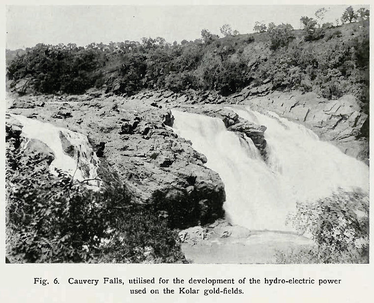
Abb.: Cauvery Falls
[Bildquelle: Thurston, Edgar <1855 - 1935>: The Madras presidency with Mysore, Coorg, and the associated states. -- Cambridge : University Press, 1913. -- xii, 293 S. : Ill. ; 23 cm. -- (Provincial geographies of India). -- S. 29. -- Online: http://www.archive.org/details/provincialgeogra03holluoft. -- Zugriff am 2008-06-21. -- "Not in copyright."]
At the end of 1894 occurred at Calcutta the sudden death of the universally respected Mahārājā Chāma Rājendra Wodeyar, in whose person the administration of Mysore had been revived in 1881, and the Mahārānī became Regent during the minority of her eldest son. This young prince, Krishna Rājā Wodeyar, who has been assiduously trained by European tutors, on attaining his majority was invested with power in 1902 by the Viceroy in person.
An epigraphic survey has been completed of the whole State1 and about 9,000 inscriptions copied in situ2. The most memorable discovery was that of edicts of Asoka in the Molakālmuru tāluk in 1892, thus lifting the veil that had hidden the ancient history of the South and marking an epoch in Indian archaeology. These and the Jain inscriptions at Sravana Belgola relating to Chandra Gupta and Bhadrabāhu, and the Sātakarni inscription at Malavalli in the Shikārpur tāluk, have filled up the gap between the rise of the Mauryas and that of the Kadambas. The origin and accession to power of the latter have been made clear by the Tālgunda pillar-inscription in the same tāluk, while the Vokkaleri plates from Kolār District throw light upon the true significance of the Pallavas. The forgotten dynasties of the Mahāvalis or Bānas, and of the Gangas who ruled Mysore for so long, have been restored to history. The chronology of the Cholas has for the first time been definitely fixed. The birthplace of the Hoysalas has been discovered, and their history worked out in detail. Most important additions have been made to the information relating to the Chālukyas, the Rāshtrakūtas, the Nolambas, the Seunas, the Vijayanagar kings, and other more modern dynasties.
1 An Archaeological department was formed in 1890, under Mr. Lewis Rice, who had been engaged for some years previously in archaeological work, in conjunction with other duties.
2 These are published in a series called Epigraphia Carnatica, extending to twelve volumes.
There have been finds of prehistoric punch-marked pieces, called purāna by the earlier Sanskrit writers, at Nagar ; of Buddhist leaden coins of the Andhra period, second century B.C. to second century A. D., at Chitaldroog ; and of Roman coins dating from 21 B. C. to A. D. 51, near Bangalore. Hoysala coins, before unknown, have been identified and their legends deciphered. The diversified coins of the modern [S. 187] States that occupied Mysore, and of Haidar and Tipū, have been tabulated and described.
Palm-leaf manuscripts have been collected, bringing to light the Kanarese literature from the earliest period, which had been lost in oblivion1.
1See introduction to Karnātaka-Sabdānusāsana. This and other classical works are being published in a series called Bibliothcca Carnatica, of which six volumes have been issued.
Prehistoric stone monuments, such as cromlechs and kistvaens, are found in most of the rocky tracts. The latter, generally called Pāndu koliy are known in Molakālmuru as Moryara mane, 'houses of the Moryas' or Mauryas, and they are so named also among the Badagas of the Nīlgiris. Stone slabs erected as memorials of heroes who fell in battle are called vīrakal. They are sculptured with bas-reliefs, of which the bottom one depicts the hero's last fight, and the others his triumphal ascent to paradise and rest there. Similar memorials to widows who have become satī and been burnt with their husbands are called mādstikal. They bear the figure of a post with a human arm extended from it, holding a lime between the thumb and forefinger. These are found mostly in the west.
The Jain temples are called basadi or bastī, and are in the Dravidian style. The chief group is on Chandragiri at Sravana Belgola. They are more ornamental externally than Jain temples in the North of India, and, Fergusson considers, bear a striking resemblance to the temples of Southern Babylonia. In front is often a māna-stambha, a most elegant and graceful monolith pillar, 30 to 50 feet high, surmounted by a small shrine or statue—lineal descendants, says the same authority, of the pillars of the Buddhists. But the Jains also have bettas, literally 'hills,' which are courtyards on a height, open to the sky, and containing a colossal nude image of Gomata. That at Sravana Belgola is 57 feet high1, and stands on the summit of Indragiri, 400 feet in elevation. It was erected about 9S3 by Chāmunda Rāya, minister of the Ganga king. Nothing grander or more imposing, says Fergusson, exists anywhere out of Egypt, and even there no known statue exceeds it in height.
1 The only other two known, which are in South Kanara and much more modern, their dates being 1431 and 1603, are 41 and 37 feet high.
The Hindu temples are of either the Chālukyan or the Dravidian style. The Hoysalas were great promoters of art, and temples erected by them or under their patronage in the twelfth and thirteenth centuries, in the highly ornate Chālukyan style, are not surpassed by any in India. The best existing examples are those at Halebīd, Belūr, and Somanāthpur. Fergusson, than whom there is no higher authority, says :—
'The great temple at Halebīd, had it been completed, is one of the [S. 188] buildings on which the advocate of Hindu architecture would desire to take his stand. The artistic combination of horizontal with vertical lines, and the play of light and shade, far surpass anything in Gothic art. The effects are just what mediaeval architects were often aiming at, but which they never attained so perfectly1.'
1 History of Indian and Eastern Architecture. See also Architecture of Dharwar and Mysore, where he says : 'It is worthy of remark that the great architectural age in India should have been the thirteenth century, which witnessed such a wonderful development of a kindred style [meaning the Gothic] in Europe.'
Examples of temples in the Dravidian style, of which the gopuram or pyramidal tower is generally the most imposing feature, may be seen at Seringapatam, Chāmundi, Melukote, and other places in the south. The bridges of Hindu construction at Seringapatam and Sivasamudram are noticed in connexion with the Cauvery.
Of Saracenic architecture the best remains are the Mughal buildings at Sīra, and the Pathān mosque at Sante Bennūr. The Gumbaz or mausoleum of Haidar and Tipū at Ganjam and the mosque at Seringapatam deserve notice. But the most ornamental is the Daryā Daulat, Tipū's summer palace at the latter place. Mr. J. D. Rees, who has travelled much in India and Persia, says :—
'The lavish decorations, which cover every inch of wall from first to last, from top to bottom, recall the palaces of Ispahān, and resemble nothing that I know in India.'
The temples of the Malnād in the west correspond in style to those of Kanara. The framework is of wood, standing on a terrace of laterite, and the whole is covered with a tiled and gabled roof. The wooden pillars and joists are often well carved.
The table below gives details of the population of the State and its constituent Districts as returned at the Census of 1901 :—
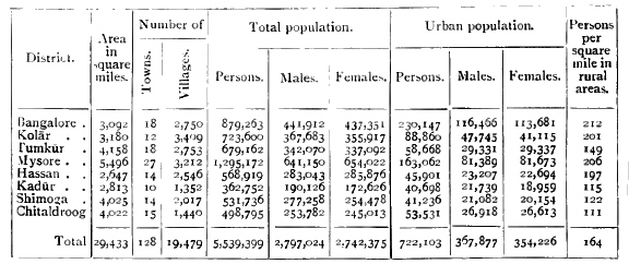
Taking the natural divisions of Malnād and Maidān, 17 per cent. of the area of the State and 12 per cent. of the population belong to the [S. 189] first, and the remainder to the second. The mean density is 185 persons per square mile. Mysore is the largest District, and contains the dynastic capital. Its total population is the highest, but in density of rural population it stands second. Bangalore District, the sixth in area, is second in total population and first in density of rural population. In it are situated the administrative capital of Mysore, and the Civil and Military Station with its large garrison, which is an Assigned Tract under British administration. The most populous tāluks are those watered by the Cauvery, with Bangalore and Anekal.
The urban population is 13 per cent. of the whole. Four places have been treated as cities in the Census of 1901 : namely, Mysore, Bangalore, the adjoining British Civil and Military Station, and the Kolār Gold Fields. The population of Bangalore (taking the city and the Civil and Military Station together) was 159,046, of Mysore city 68,111, and of the Gold Fields 38,204. Owing chiefly to plague, there had been since 1891 a loss of 21,320 in Bangalore and of 5,937 in Mysore, while, in spite of plague, the Gold Fields gained 31,119. The number of towns is 124, of which Mysore, Tumkūr, and Bangalore Districts contain 26, 18, and 16 respectively, and Kolār and Kadūr only 11 and 10. A town is a municipality of whatever size, or a place not absolutely rural containing a population of 5,000 and above. Only five of these towns have a population exceeding 10,000—Kolār, Tumkūr, Channapatna, Dāvangere, and Tarikere—while the population of twenty-seven lies between 5,000 and 10,000, of which eight belong to Mysore and five to Bangalore District. The inhabited villages number 16,884. In the Maidān a village may have dependent hamlets grouped with it. In the Malnād, villages are often such only in name, being composed of scattered homesteads at various distances apart. The towns and villages vary little as regards the main occupations and habits of life of the people, but those which are also market places or tāluk headquarters become centres of trade and home industries. The number of houses per square mile rose from 25 in 1881 to 37 in 1901, and the occupants per house averaged 5 at the latter date as compared with 5-6 twenty years before.
The variation in total population at each Census has been : (1871) 5,055,102,(1881)4,186,188, (1891) 4,943,604, and (1901) 5.539.399. The fall in 1881 was due to the great famine of 1876-8, but was almost compensated by the rise in 1891. In spite of plague, the last Census shows a marked general increase of 12 per cent. The rise has been greatest in Kolār and Chitaldroog Districts, and least in Kadūr, the population of which has scarcely varied. The increase in the Districts of Mysore, Hassan, and Shimoga is below the average.
In 1901, according to the census returns, 306,381 persons enumerated [S. 190] in the State had been born out of it, and 132,342 born in the State were registered elsewhere. The greatest increase of foreign immigrants is of course in Kolār, in connexion with the gold-mines. But all the Districts show an increase under this head, especially Hassan and Kadūr, which are coffee-growing tracts.
The percentage distribution of the total population under different age periods is as follows : 13.03 of ages 0 to 5 ; 26.87 of 5 to 15 ; 22.01 of 15 to 30; 20.63 of 30 to 45 ; 11.93 of 45 to 60; and 5.51 of 60 and over. Females are in a total ratio of 981 to 1,000 males, but they exceed males at ages 3 to 4, 20 to 35, 50 to 55, and at 60 and over. Except in Bangalore city and Civil and Military Station, and in Mysore city, vital statistics cannot be accepted as reliable ; and even in those places it is chiefly since the outbreak of plague in 1898 that particular attention and scrutiny have been given to them, with special reference to the number of deaths. In other parts the pātel or headman has to keep up the register, under the control of the revenue officers ; but as there is no obligation on householders to report domestic occurrences, he can hardly be held responsible for the accuracy of the returns. The following table is compiled from such statistics as are available, but the numbers of both births and deaths are manifestly understated :
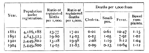
For the decade ending 1901, Chitaldroog and Mysore show the highest and lowest birth-rates respectively, and Shimoga and Tumkūr the highest and lowest death-rates.
There were 1,025,838
cases treated in the hospitals and dispensaries of the State in 1901, of which
46 per cent. were those of men, and the rest of women and children in the
proportion of about 2 to 3. The diseases treated are classed as general or local,
42 per cent. belonging to the former class. Of these, the most numerous were
malarial fevers, worms, rheumatic affections, debility and anaemia, and venereal
diseases. Of local, the greater number were diseases of the skin, the digestive
system, the eye, the lungs, and injuries.
Plague first appeared in August, 1898, at Bangalore, being imported by rail from
Dhārwār. By the end of June, 1904, it had claimed 106,950 victims in the whole
State, out of 141,403 cases of seizure. In [S. 191] other words, 2.5 per cent. of the population
were attacked by plague, and of those attacked nearly 76 per cent.
died. The figures for each year show a large decrease in 1899-1900
and a rise since. With 1903-4 the numbers are again going down. The
temporary decrease in the second year was probably due to
extensive exodus to other parts, a drier season owing to deficient rainfall,
general inoculation, and enforcement of passport regulations. Special
restrictions have since been virtually withdrawn ; but evacuation of
infected places, general or local disinfection by chemicals or
desiccation, and the opening out of congested parts are in operation1. No place
has suffered more than Mysore city, where 17 per cent. of the
deaths have occurred. A regulation was passed in 1903 appointing a
special board for the improvement of the city. Shimoga and
Kadūr
Districts were free till 1900, and Chitaldroog District had no deaths
from plague in that year. The disease seems to be at its maximum
about October, and at its minimum about May, these being
respectively the wettest and driest months in the year.
1 Large extensions have been added to Bangalore city, and a new town on modern lines has been laid out at the Kolār Gold Fields.
The figures obtained at the Census of 1901 are a gauge of the infant mortality occasioned by the famine of 1876-8, and by the unhealthy years, culminating in plague, of the decade ending 1901. The following table gives the ratio of infants of either sex to 1,000 of the same sex :—
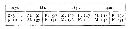
The proportion of females to 1,000 males in the whole State in 1901 was 981, the figures for the urban population being 963, and for the rural 983. In 1871 the proportion was 994, in 1881 it was 1,007, and in 1891 it was 991. The relative number of females has thus fallen considerably in the thirty years. Hindus exceeded the general average at each Census. Christians had the fewest females in the three previous census years, and in 1901 this position was held by the Jains. Females exceed males in Mysore and Hassan Districts (1,020 and 1,010), and are most in defect in Shimoga and Kadūr (918 and 908). In the Civil and Military Station of Bangalore the ratio is 986, in Mysore city 984, in Bangalore city 931, and in the Kolār Gold Fields only 699, as might be expected. Since 1891 males have increased by 12.6 per cent. and females by 11.4.
The unmarried, the married, and the widowed are respectively 47.46, 40.34, and 12.20 per cent. of the population. Females form 41 percent. [S. 192] of the unmarried, 51 of the married, and 79 of the widowed. Christians have the highest proportion of unmarried and the lowest of widowed in both sexes. Next come Animists and Musalmāns, with lower proportions of unmarried and higher of widowed. The Jains have a higher ratio of bachelors than the Hindus, but among them spinsters are proportionately fewest and widowers and widows most numerous.
Infant marriage of girls prevails most among the Jains and Hindus, and scarcely at all among Christians, but there are cases in all religions. Of 1,000 married females, 54 are under five years of age. But of course these are really cases of betrothal, though as irrevocable as marriage, and causing widowhood if death should intervene. Chitaldroog District shows the highest proportion of such cases ; certain subdivisions of Wokkaligas there are said to have a custom of betrothing the children of near relations to one another within a few months of their birth, the tāli, or token of the marriage bond, being tied to the cradle of the infant girl. Some of the Panchāla artisans and devotee Lingāyats seem especially given to infant marriage. By a Regulation of 1894 the marriage of girls under 8 has been prohibited in Mysore, and also that of girls under 14 to men of over 50. Of the total number of married females, 7.6 per cent. are under 15, and 12.3 per cent. between 15 and 20. Among Brāhmans and Komatis girls must be married before puberty, and in the majority of cases the ceremony takes place between 8 and 12. In other castes girls are mostly married between the ages of 10 and 20. Above this age there are very few spinsters, and these principally among native Christians, though among Lambānis and Iruligas, classed as Animists, brides are often over 30. Of widows, more than 73 per cent. are over 40. Roughly speaking, among Christians and Jains one widow in 3 is under 40, in the other religions one in 4. After 40 more than half the women are widows. Remarriage of widows is utterly repugnant to most Hindu castes, though permissible in some of the lower ones. It appears from the census returns that 5.8 per cent. of widows were remarried ; but this was principally among Woddas and Jogis, who are not socially very important, and among Musalmān Labbais and nomad Koramas.
Of the male sex, seven youths under 15 in 1,000 are married; from 15 to 20 there are 13.3 per cent. married and 0.2 per cent. widowers ; from 20 to 40 there are 69 per cent. married and 3.7 per cent. widowers; over 40 there are 78.7 per cent. married and 17.7 per cent. widowers.
Polygamy is rare, though allowed by all classes except Christians. Cast-off or widowed women of the lower orders sometimes attach themselves as concubines to men who have legitimate wives. Among the higher castes a second wife is taken only when the first proves barren, or is incurably ill, or immoral. But unless put away for [S. 193] immoral conduct, the first wife alone is entitled to join the husband in religious ceremonies, and the second can do so only with her consent. The proportion of married men who have more than one wife is 18 in 1,000. Animists and Musalmāns stand highest in this respect, and next come labouring and agricultural classes such as Woddas, Idigas, Wokkaligas, and Kurubas.
There are no statistics for divorce. Polyandry and infanticide are unknown in Mysore, as also inheritance through the mother. The joint family system continues among Hindus, but modern influences are tending to break it up.
The distinctive language of Mysore is Kannada, the Karnāta or Karnātaka of the pandits, and the Kanarese of European writers. It is the speech of 73 per cent. of the population, and prevails everywhere except in the east. Telugu, confined to Kolār District and some of the eastern tāluks, is the language of 15 per cent. Tamil (called here Arava) is the speech of 4 per cent., and predominates at the Kolār Gold Fields and among the servants of Europeans, camp-followers, and cantonment traders. A more or less corrupt Tamil is spoken by certain long-domiciled classes of Brāhmans (Srīvaishnava, Sanketi, and Brihachcharana), and by Tigala cultivators, but its use is only colloquial. Marāthī, which is spoken by 1.4 per cent. of the population, is the language of Deshasth Brāhmans and Darzis or tailors, the former being most numerous in Shimoga District. Hindustānī, the language of Musalmāns, who form 5.22 per cent. of the population, is spoken by only 4.8 per cent., the difference being due to the Labbais and other Musalmāns from the south who speak Tamil. In each of these vernaculars there has been since 1891 an increase of about 11 per cent., except in Tamil, which has increased 42 per cent., owing to the influx of labour at the gold-mines and partly on the railways.
The Hindus have been arranged under 72 castes or classes. Of these, the strongest numerically are Wokkaligas (1,287,000), Lingāyats (671,000), and Holeyas (596,000), who between them make up 46 per cent. of the total population. The Wokkaligas (in Hindustānī, Kunbī) are the cultivators or ryots. They include numerous tribes, some of Kanarese and some of Telugu origin, who neither eat together nor intermarry. Their headmen are called Gaudas. Marriage is not always performed before puberty, and polygamy has some vogue, the industry of the women being generally profitable to the husband. Widow remarriage is allowed, but lightly esteemed. The Wokkaligas are mostly vegetarians and do not drink intoxicating liquor. They bury their dead. The Gangadikāra, who form nearly one-half of the class, are purely Kanarese, found chiefly in the central and southern tracts. They represent the subjects of the ancient Gangavādi which formed the nucleus of the Ganga empire. At the present day they are [S. 194] followers some of Siva and some of Vishnu. Next in numbers are the Morasu Wokkaligas, chiefly in Kolār and Bangalore Districts. They appear to have been originally immigrants from a district called Morasu-nād, to the east of Mysore, whose chiefs formed settlements at the end of the fourteenth century in the parts round Nandidroog. The section called Beralukoduva (' finger-giving ') had a strange custom, which, on account of its cruelty, was put a stop to by Government. Every woman of the sect, before piercing the ears of her eldest daughter preparatory to betrothal, had to suffer amputation of the ring and little fingers of the right hand, the operation being performed by the village blacksmith with a chisel. The sacred place of the Morasu Wokkaligas is Sīti-betta in the Kolār tāluk, where there is a temple of Bhairava. Of other large tribes of Wokkaligas, the Sāda abound mostly in the north and west. They include Jains and Lingāyats, Vaishnavas and Saivas. Not improbably they all belonged originally to the first. In the old days many of them acted in the Kandāchār or native militia. They are not only cultivators but sometimes trade in grain. The Reddi are found chiefly in the east and north, and have numerous subdivisions. To some extent they seem to be of Telugu origin, and have been supposed to represent the subjects of the ancient Rattavādi, or kingdom of the Rattas. The Nonabas, in like manner, are relics of the ancient Nolambavādi or Nonambavādi, a Pallava province, situated in Chitaldroog District. At the present day they are by faith Lingāyats, the residence of their chief guru being at Gaudikere near Chiknāyakanhalli. The acknowledged head of the Nonabas lives at Hosahalli near Gubbi. The Halepaiks of the Nagar Malnād are of special interest as being probably aboriginal. Their name is said to mean the 'old foot,' as they furnished the foot-soldiers and body-guards of former rulers, to whom they were noted for their fidelity. Their principal occupation now is the extraction of toddy from the bagni-palm (Caryota urens), the cultivation of rice land, and of kāns or woods containing pepper vines ; but they are described as still fond of firearms, brave, and great sportsmen. In Vastāra and Tuluva (South Kanara) they are called Billavas or 'bowmen.' In Manjarābād they are called Devara makkalu, 'God's children.' The Hālu Wokkaligas are mostly in Kadūr and Hassan Districts. They are dairymen and sell milk (hālu) whence their name, as well as engage in agriculture. The Hallikāra are also largely occupied with cattle, the breed of their name being the best in the Amrit Mahāl. The Lālgonda, chiefly found in Bangalore District, not only farm, but hire out bullocks, or are gardeners, builders of mud walls, and traders in straw, &c. The Vellāla are the most numerous class of Wokkaligas in the Civil and Military Station of Bangalore. Another large class, as numerous as the Reddi, are the Kunchitiga, widely spread but mostly found in the [S. 195] central tracts. The women prepare and sell dāl (pigeon pea), while the men engage in a variety of trades.
The Holeyas (Tamil, Paraiya ; Marāthī, Dhed) are outcastes, occupying a quarter of their own, called the Holageri, outside every village boundary hedge. They are indigenous and probably aboriginal. They have numerous subdivisions, which eat together but only intermarry between known families. A council of elders decides all questions of tribal discipline. They are regarded as unclean by the four principal castes, and particularly by the Brāhmans. In rural parts especially, a Holeya, having anything to deliver to a Brāhman, places it on the ground and retires to a distance, and on meeting a Brāhman in the road endeavours to get away as far as possible. Brāhmans and Holeyas mutually avoid passing through the parts they respectively occupy in the villages ; and a wilful transgression in this respect, if it did not create a riot, would make purification necessary, and that for both sides. They often take the vow to become Dāsari, and regard the Sātāni as priests, but a Holeya is himself generally the priest of the village goddess. Under the name of Tirukula, the Holeyas have the privilege of entering the great temple at Melukote once a year to pay their devotions, said to be a reward for assisting Rāmānuja to recover the image of Krishna which had been carried off to Delhi by the Musalmāns. The Holeya marriage rite is merely a feast, at which the bridegroom ties a token round the bride's neck. A wife cannot be divorced except for adultery. Widows may not remarry, but often live with another man. The Holeyas eat flesh and fish of all kinds, and even carrion, provided the animal died a natural death, and drink spirituous liquors. As a body the Holeyas are the servants of the ryots, and are mainly engaged in following the plough and watching the herds. They also make certain kinds of coarse cloth, worn by the poorer classes. The Alemān section furnishes recruits for the Barr sepoy regiments. In the Maidān a Holeya is the kulavādi, and has a recognized place in the village corporation. He is the village policeman, the beadle, and the headman's factotum. The kulavādis are the ultimate referees in cases of boundary disputes, and if they agree no one can challenge the decision. In the Malnād the Holeya was merely a slave, of which there were two classes : the huttāl, or slave born in the house, the hereditary serf of the family ; and the mannāl, or slave of the soil, who was bought and sold with the land. Now these have of course been emancipated, and some are becoming owners of land. In urban centres they are rising in respectability and acquiring wealth, so that in certain cases their social disabilities are being overcome, and in public matters especially their complete ostracism cannot be maintained.
Ten other castes, each above 100,000, make up between them 30 [S. 196] per cent. of the population. They are the Kuruba (378,000), Mādiga (280,000), Beda or Bedar (245,000), Brāhman (190,000), Besta (153,000), Golla (143,000), Wodda (135,000), Banajiga (123,000), Panchāla (126,000), and Uppāra (106,000). The Kurubas are shepherds and weavers of native blankets (kambli). There is no intercourse between the general body and the division called Hande Kurubas. The former worship Bire Deva and are Saivas, their priests being Brāhmans and Jogis. The caste also worship a box, which they believe contains the wearing apparel of Krishna, under the name of Junjappa. Parts of Chitaldroog and the town of Kolār are noted for the manufacture by the Kurubas there of a superior woollen of fine texture like homespun. The women spin wool, and as they are very industrious, polygamy prevails, and even adultery is often condoned, their labour being a source of profit. The wild or Kādu Kurubas (8,842) are subdivided into Betta or 'hill,' and Jenu or 'honey,' Kurubas. The former are a small and active race, expert woodmen, and capable of enduring great fatigue. The latter are a darker and inferior race, who collect honey and beeswax. Their villages or clusters of huts are called hadi; and a separate hut is set apart at one end for the unmarried females to sleep in at night, and one at the other end for the unmarried males, both being under the supervision of the headman. Girls are married only after puberty, either according to the Wokkaliga custom, or by a mere formal exchange of areca-nut and betel-leaf. Polygamy exists, but the offspring of concubines are not considered legitimate. All kinds of meat except beef are eaten, but intoxicating drinks are not used. In case of death, adults are cremated and children buried. The Betta Kurubas worship forest deities called Norāle and Māstamma, and are said to be revengeful, but if treated kindly will do willing service. The Jenu Kurubas neither own nor cultivate land for themselves, nor keep live-stock of their own. Both classes are expert in tracking wild animals, as well as skilful in eluding pursuit by wild animals accidentally encountered. Their children when over two years old move about freely in the jungle.
The Mādigas are similar to the Holeyas, but distinguished from them by being workers in leather. They remove the carcases of dead cattle, and dress the hides to provide the villagers with leathern articles, such as the thongs for bullock yokes, buckets for raising water, &c. They are largely engaged in field labour, and in urban centres are earning much money, owing to the increasing demand for hides and their work as tanners. They worship Vishnu, Siva, and their female counterparts or Saktis, and have five different gurus or maths in the State. They have a division called Desabhāga, who do not intermarry with the others. They acknowledge Srīvaishnava Brāhmans as their gurus, and have also the names Jāmbavakula and Mātanga. They are [S. 197] privileged to enter the courtyard of the Belūr temple at certain times to present the god with a pair of slippers, which it is the duty of those in Channagiri and Basavāpatna to provide. Their customs are much the same as those of the Holeyas. The Bedas (Bedar), or Naiks, are both Kanarese and Telugu, the two sections neither eating together nor intermarrying. One-third are in Chitaldroog District, and most of the rest in Kolār and Tumkūr. They were formerly hunters and soldiers by profession, and largely composed Haidar's and Tipū's infantry. Many of the M)sore poligārs were of this caste. They now engage in agriculture, and serve as police and revenue peons. They claim descent from Vālmīki, author of the Rāmāyana, and are chiefly Vaishnavas, but worship all the Hindu deities. In some parts they erect a circular hut for a temple, with a stake in the middle, which is the god. In common with the Golla, Kuruba, Mādiga, and other classes, they often dedicate as a Basavi or prostitute the eldest daughter in a family when no son has been born ; and a girl falling ill is similarly vowed to be left unmarried, i.e. to the same fate. If she bear a son, he is affiliated to her father's family. Except as regards beef, they are not restricted in food or drink. Polygamy is not uncommon, but divorce can be resorted to only in case of adultery. Widows may not remarry, but often live with another Beda. The dead are buried. The caste often take the vow to become Dāsari. Their chief deity is the god Venkataramana of Tirupati, locally worshipped under the name Tirumala, but offerings and sacrifices are also made to Māriamma. Their guru is known as Tirumala Tatāchārya, a head of the Srīvaishnava Brāhmans. The Māchi or Myāsa branch, also called Chunchu, circumcise their boys at ten or twelve years of age, besides initiating them with Hindu rites. They eschew all strong drink, and will not even touch the date-palm from which it is extracted. They eat beef, but of birds only partridge and quail. Women in childbirth are segregated. The dead are cremated, and their ashes scattered on tangadi bushes (Cassia auriculata). This singular confusion of customs may perhaps be due to the forced conversion of large numbers to Islam in the time of Haidar to form his Chela battalions. The Telugu Bedas are called Boya. One section, who are shikris, and live on game and forest produce, are called Myāsa or Vyādha. The others are settled in villages, and live by fishing and day labour. The latter employ Brāhmans and Jangamas as priests, but the former call in elders of their own caste. The Myāsa women may not wear toe-rings, and the men may not sit on date mats.
Bestas are fishermen, boatmen, and palanquin-bearers. This is their name in the east; in the south they are called Toreya, Ambiga, and Parivāra ; in the west Kabyara and Gangemakkalu. Those who speak Telugu call themselves Bhoyi, and have a headman called Pedda [S. 198] Bhoyi. One section are lime-burners. Some are peons, and a large number engage in agriculture. Their domestic customs are similar to those of the castes above mentioned. Their goddess is Yellamma, and they are mostly worshippers of Siva. They employ Brāhmans and Sātānis for domestic ceremonies. The Gollas are cowherds and dairymen. The Kādu or 'forest' Gollas are distinct from the Uru or 'town' Gollas, and the two neither eat together nor intermarry. One section was formerly largely employed in transporting money from one part of the country to another, and gained the name Dhanapāla. One of the servants in Government treasuries is still called the Golla. They worship Krishna as having been born in their caste. The Kādu Gollas are nomadic, and live in thatched huts outside the villages. At childbirth the mother and babe are kept in a small hut apart from the others for from seven to thirty days. If ill, none of her caste will attend on her, but a Naik or Beda woman is engaged to do so. Marriages are likewise performed in a temporary shed outside the village, to which the wedded pair return only after five days of festivity. Golla women do not wear the bodice, nor in widowhood do they break off their glass bangles. Remarriage of widows is not allowed.
The Woddas are composed of Kallu Woddas and Mannu Woddas, between whom there is no social intercourse or intermarriage. The Kallu Woddas, who consider themselves superior to the others, are stonemasons, quarrying, transporting, and building with stone, and are very dexterous in moving large masses by simple mechanical means. The Mannu Woddas are chiefly tank-diggers, well-sinkers, and generally skilful navvies for all kinds of earthwork, the men digging and the women removing the earth. Though a hard-working class, they have the reputation of assisting dacoits and burglars by giving information as to plunder. The young and robust of the Mannu Woddas of both sexes travel about in caravans in search of employment, taking with them their infants and huts, which consist of a few sticks and mats. On obtaining any large earthwork, they form an encampment in the neighbourhood. The older members settle in the outskirts of towns, where many of both .sexes now find employment in various kinds of sanitary work. They were probably immigrants from Orissa and the Telugu country, and generally speak Telugu. They eat meat and drink spirits, and are given to polygamy. Widows and divorced women can remarry. Both classes worship all the Hindu deities, but chiefly Vishnu.
The Banajigas are the great trading class. The subdivisions are numerous, but there are three main branches— the Panchama, Telugu, and Jain Banajigas— who neither eat together nor intermarry. The first are Lingāyats, having their own priests, who officiate at marriages [S. 199] and funerals, and punish breaches of caste discipline. Telugu Banajigas are very numerous. The Saivas and Vaishnavas among them do not intermix socially. The latter acknowledge the guru of the Srīvaishnava Brāhmans. They frequently take the vow to become Dāsari. Many dancing-girls are of this caste. The Panchāla, as their name implies, embrace five guilds of artisans : namely, goldsmiths, brass and coppersmiths, blacksmiths, carpenters, and sculptors. They wear the triple cord and consider themselves equal to the Brāhmans, who, however, deny their pretensions. The goldsmiths are the recognized heads of the clan. The Panchāla have a guru of their own caste, though Brāhmans officiate as purohits. The Uppāra are saltmakers. This is their name in the east ; in the south they are called Uppaliga, and in the west Melusakkare. There are two classes, Kannada and Telugu. The former make earth-salt, while the latter are bricklayers and builders. They are worshippers of Vishnu and Dharma Rāya.
The agricultural, artisan, and trading communities form a species of guilds called phana (apparently a very ancient institution), and these are divided into two factions, termed Balagui (right-hand) and Yedagai (left-hand). The former contains 18 phana, headed by the Banajiga and Wokkaliga, with the Holeya at the bottom ; while the latter contains 9 phana, with the Panchāla and Nagarta (traders) at the head, and the Mādiga at the bottom. Brāhmans, Kshattriyas, and most of the Sūdras are considered to be neutral. Each party insists on the exclusive right to certain privileges on all public festivals and ceremonies, which are jealously guarded. A breach on either side leads to faction fights, which formerly were of a furious and sometimes sanguinary character. Thus, the right-hand claim the exclusive privilege of having 12 pillars to the marriage pandal, the left-hand being restricted to 11; of riding on horseback in processions, and of carrying a flag painted with the figure of Hanuman. In the Census of 1891 the people by common consent repudiated the names Balagai and Yedagai, and preferred to return themselves as of the 18 phana or the 9 phana. In the Census of 1901 even this distinction was ignored, and the people returned themselves in various irreconcilable ways, mostly as belonging to the 12 phana. The old animosity of the factions seems to be wearing away.
Of nomad tribes, more than half are Lambānis and another fourth are Koracha, Korama, or Korava. The first are a gipsy tribe that wander about in gangs with large herds of bullocks, transporting grain and other produce, especially in the hilly and forest tracts. Of late years some have been employed on coffee estates, and some have even partially abandoned their vagrant life, and settled, at least for a time, in villages of their own. These, called tāndas, are composed of groups [S. 200] of their usual rude wicker huts, pitched on waste ground in wild places. The women bring in bundles of firewood from the jungles for sale in the towns. The Lambānis speak a mixed dialect called Kutnī largely composed of Hindī and Marāthī corruptions. The women are distinguished by a picturesque dress different from that worn by any other class. It consists of a sort of tartan petticoat, with a stomacher over the bosom, and an embroidered mantle covering the head and upper part of the body. The hair is worn in ringlets or plaits, hanging down each side of the face, decorated with small shells, and ending in tassels. The arms and ankles are profusely covered with trinkets made of bone, brass, and other rude materials. The men wear tight cotton breeches, reaching a little below the knee, with a waistband ending in red silk tassels, and on the head a small red or white turban. There is a class of Lambāni outcastes, called Dhālya, who are drummers and live separately. They chiefly trade in bullocks. The Lambānis hold Gosains as their gurus, and reverence Krishna ; also Basava, as representing the cattle that Krishna tended. But their chief object of worship is Banashankarī, the goddess of forests. Their marriage rite consists of mutual gifts and a tipsy feast. The bridal pair also pour milk down an ant-hill occupied by a snake, and make offerings to it of coco-nuts and flowers. Polygamy is in vogue, and widows and divorced women may remarry, but with some disabilities. The Lambānis are also called Sukāli and Brinjāri. The Koracha, Korama, or Korava are a numerous wandering tribe, who carry salt and grain from one market to another by means of large droves of cattle and asses, and also make bamboo mats and baskets. The men wear their hair gathered up into a big knot or bunch on one side of the top of the head, resembling what is seen on ancient sculptured stones. The women may be known by numerous strings of small red and white glass beads and shells, worn round the neck and falling over the bosom. In the depths of the forest they are even said to dispense with more substantial covering. A custom like couvade is said to linger among the Korava, but this is not certain. The dead are buried at night in out-of-the-way spots. The women are skilful in tattooing. The Iruliga are the remaining wild tribe, and include the Sholaga, who live in the south-east in the Biligiri-Rangan hills. They are very dark, and are keen-sighted and skilful in tracking game. They cultivate small patches of jungle clearings with the hoe, on the kumri or shifting system. Polygamy is the rule among them, and adultery is unknown. When a girl consents to marriage, the man runs away with her to some other place till the honeymoon is over, when they return home and give a feast. They live in bamboo huts thatched with plantain leaves.
The percentage of the followers of each religion to the whole population [S. 201] at the Census of 1901 was, in order of strength : Hindus, 92.1 ; Musalmāns, 5.2 ; Animists, 1.6 : Christians, 0.9 ; Jains, 0.2. There remained 158 persons who were Parsis, Sikhs, Jews, Brahmos, or Buddhists : 101 were Parsis and 34 Jews. The percentage of increase in each religion since 1891 was: Christians, 31.3: Musalmāns, 14.5; Hindus, 11.5; Jains, 3.
Of Hindu religious sects in Mysore, Lingāyats are by far the strongest in numbers ; and if, in addition to those returned as such, the Nonaba, Banajiga, and others belonging to the sect be taken into account, they cannot be much below 800,000. Their own name for themselves is Sivabhakta or Sivāchr, and Vīra Saiva. Their distinctive mark is the wearing of a jangama (or portable) lingam on the person, hence the name Lingāyata or Lingavanta. The lingam is a small stone, about the size of an acorn, enshrined in a silver casket of peculiar shape, worn suspended from the neck or bound to the arm. They also mark the forehead with a round white spot. The clerics smear their faces and bodies with ashes, and wear garments of the colour of red ochre, with a rosary of rudrksha beads round the neck.
Phallic worship is no doubt one of the most ancient and widely diffused forms of religion in the world, and the Lingāyats of late have made doubtful pretensions to date as far back as the time of Buddha. Among the Saiva sects mentioned by the reformer Sankarāchārya as existing in India in the eighth century were the Jangamas, who he says wore the trident on the head and carried a lingam made of stone on their persons, and whom he denounces as unorthodox. Of this sect the Lingāyats claim to be the representatives. Whether this be so or not, it is undoubted that the Lingāyat faith has been the popular creed of the Kanarese-speaking countries from the twelfth century.
Lingāyats reject the authority of Brāhmans and the inspiration of the Vedas, and deny the efficacy of sacrifices and srāddhas. They profess the Saiva faith in its idealistic form, accepting as their principal authority a Saiva commentary on the Vedānta Sūtras. They contend that the goal of karma or performance of ceremonies is twofold—the attainment of svarga or eternal heavenly bliss, and the attainment of jnāna or heavenly wisdom. The former is the aim of Brāhman observances ; the latter, resulting in union with the deity, is the summum bonum of the Lingāyats.
The Lingāyat sect in its present form dates from about 1160, a little more than forty years after the establishment of the Vaishnava faith and the ousting of the Jains in Mysore by Rāmānujāchārya. Its institution is attributed to Basava, prime minister of the Kalachuri king Bijjala, who succeeded the Chālukyas and ruled at Kalyāni (in the Nizām's Dominions) from 1155 to 1167. Basava (a vernacular form of the Sanskrit vrishabha, 'bull') was supposed to be an incarnation [S. 202] of Siva's bull Nandī, sent to the earth to revive the Saiva religion. He was the son of an Arādhya Brāhman, a native of Bāgevādi in Bijāpur District. He refused to be invested with the sacred thread, or to acknowledge any guru but Siva, and incurred the hostility of the Brāhmans. He retired for some time to Sangamesvara, where he was instructed in the tenets of the Vīra Saiva faith. Eventually he went to Kalyāni, where the king Bijjala, who was a Jain, married his beautiful sister and made him prime minister. This position of influence enabled him to propagate his religious system. Meanwhile, a sister who was one of his first disciples had given birth to Channa Basava, supposed to be an incarnation of Siva's son Shanmukha, and he and his uncle are regarded as joint founders of the sect. The Basava Purāna and Channa Basava Purāna, written in Hala Kannada, though not of the oldest form, containing miraculous stories of Saiva gurus and saints, are among their chief sacred books. Basava's liberal use of the public funds for the support of Jangama priests aroused the king's suspicions, and he thoughtlessly ordered two pious Lingāyats to be blinded, which led to his own assassination. Basava and Channa Basava fled from the vengeance of his son, and are said to have been absorbed into the god. The reformed faith spread rapidly, superseding that of the Jains ; and according to tradition, within sixty years of Basava's death, or by 1228, it was embraced from Ulavi, near Goa, to Sholāpur, and from Bālehalli (in Kadūr District) to Sivaganga (Bangalore District). It was a State religion of Mysore from 1350 to 1610, and especially of the Keladi, Ikkeri, or Bednūr kingdom from 1550 to 1763, as well as of various neighbouring principalities. Since the decline of the Jains, the Lingāyats have been preservers and cultivators of the Kanarese language.
The sect was originally recruited from all castes, and observances of caste, pilgrimage, fasts, and penance were rejected. Basava taught that all holiness consisted in regard for three things, guru, lingam, and jangam—the guide, the image, and the fellow religionist. But caste distinctions are maintained in regard to social matters, such as intermarriage. The lingam is tied to an infant at birth, must always be worn to the end of life, and is buried with the dead body. At a reasonable age the child is initiated by the guru into the doctrines of the faith. All are rigid vegetarians. Girls are married before puberty. Widows do not marry again. The dead are buried. The daily ritual consists of Saiva rites, and it may be stated that lingam worship, in both act and symbol, is absolutely free from anything indecorous. Five spiritual thrones or simhāsanas were originally established : namely, at Bālehalli (Kadūr District), Ujjain, Kāsī (Benares), Srīsailam (Kurnool District), and Kedārnāth (in the Himālayas). Maths still exist in these places and exercise jurisdiction over their respective spheres. [S. 203]
The Lingāyats are a peaceful and intelligent community, chiefly engaged in trade and agriculture. In commerce they occupy a very prominent place, and many are now taking advantage of the facilities for higher education and qualifying for the professions.
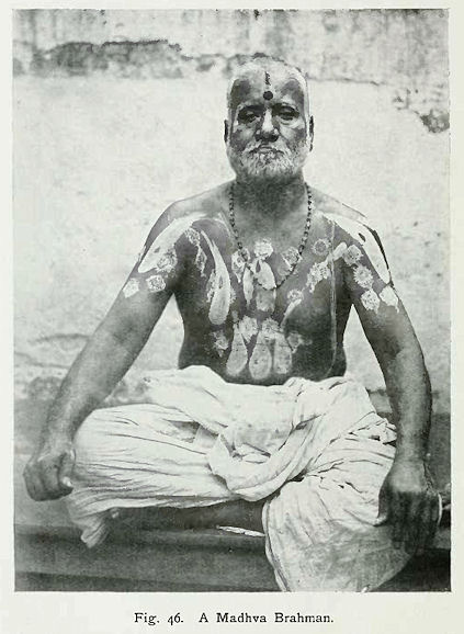
Abb.: Mādhva Brāhman
[Bildquelle: Thurston, Edgar <1855 - 1935>: The Madras presidency with Mysore, Coorg, and the associated states. -- Cambridge : University Press, 1913. -- xii, 293 S. : Ill. ; 23 cm. -- (Provincial geographies of India). -- S. 132. -- Online: http://www.archive.org/details/provincialgeogra03holluoft. -- Zugriff am 2008-06-21. -- "Not in copyright."]
The Brāhmans (190,050) are divided among four sects : namely, Smartas, who form 63 per cent.; Mādhvas, 23 per cent.; Srīvaishnavas, 10 per cent.; and Bhāgavatas, 4 per cent.
Smartas are followers of the smriti, and hold the Advaita doctrine.
Their chief deity is Siva, and the sect was founded by
Sankarāchārya in the
eighth century. Their guru is the head of the math established by him at Sringeri (Kadūr District), who is styled the Jagad Guru.
They are distinguished by three parallel horizontal lines of sandal
paste or cow-dung ashes on the forehead, with a round red spot in the
centre.
The Mādhvas are named after their founder
Madhvāchārya, who
lived in South Kanara in the thirteenth century. They especially
worship Vishnu, and hold the Dvaita doctrine. Their gurus are at
Nanjangūd, Hole-Narsipur, and Sosile. They wear a black perpendicular
line from the junction of the eyebrows to the top of the forehead,
with a dot in the centre.
The Srīvaishnavas worship Vishnu as identified with his consort Srī, and hold the Visishtādvaita doctrine. The sect was founded by Rāmānujāchārya early in the twelfth century. There are two branches :
the Vadagalai ('northerners'), who form two-thirds, and adhere to the sacred texts in Sanskrit;
and the Tengalai ('southerners'), who form one-third, and have their sacred texts in Tamil.
Their mark is a trident on the forehead, the centre line being
yellow or red and the two outer ones white. The Tengalai continue the
central line of the trident in white for some distance down the nose.
The Bhāgavatas are probably a very ancient sect. They are classed with Smartas, but chiefly worship Vishnu, and wear Vaishnava perpendicular marks. Nearly all the Brāhmans in Mysore belong to the Pancha Dravida or 'five tribes of the south.'
The Sātāni (22,378) are the next most numerous religious sect. They are regarded as priests by the Holeya and other inferior castes, and themselves have the chiefs of the Srīvaishnava Brāhmans and Sannyāsis as their gurus. They are votaries of Vishnu, especially in the form of Krishna, and are followers of Chaitanya. As a rule they are engaged in the service of Vaishnava temples, and are flower-gatherers, torch-bearers, and strolling musicians. They call themselves Vaishnavas, the Baisnabs of Bengal.
Of Musalmāns the majority are Sunnis, very few being Shiahs. There are thirteen Musalmān classes, the most numerous of which are Shaikh (178,625), Saiyid (42,468), Pathān (41,156), Mughal (8,241), Labbai (6,908), and Pinjari (4,558). The first four are mostly in the army, police, and other Government service, but many are merchants [S. 204] and traders. The Labbai are descendants of Arabs and women of the country. They come from Negapatam and other parts of the Coromandel coast, and speak Tamil. They are an enterprising class of traders, settled in most of the towns, vendors of hardware and other articles, collectors of hides, and traders in coffee ; but they take up any lucrative business. Some are settled as agriculturists at Gargeswari in Mysore District. The Māppilla or Moplah are of similar origin but from the Malabar coast, and speak Malayālam. They are principally on the coffee plantations in the west. At one time there were many at the Kolār gold-mines. The Pinjari are cotton-ginners and cleaners ; other Musalmāns as a rule have no intercourse with them. At Channapatna and one or two other places is a sect called Daire, who came originally from Hyderābād. They believe the Mahdi to have come and gone, and do not intermarry with other Musalmāns. They trade in silk with the West Coast.
Christians at the Census of 1901 numbered 50,059: namely, Europeans, 4,753; Eurasians, 5,721; and native Christians, 39,585. The first two classes are mostly in Bangalore and the Kolār Gold Fields, but they are also scattered in various parts of the country. European coffee-planters reside in Kadūr and Hassan Districts. The principal Eurasian rural settlement is Whitefield in Bangalore District. The same District and the Kolār Gold Fields contain the largest number of native Christians. They have increased by 41.6 per cent. since 1891, or, excluding the Civil and Military Station of Bangalore, by 62.8 per cent. The following were the principal denominations returned :—
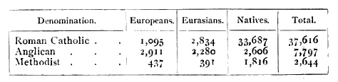
The Roman Catholics increased by 29 per cent. in the decade. As regards the Anglicans and Methodists, it appears that some belonging to the latter denomination entered themselves merely as Protestants, and were thereby included among the former. Putting both together, to rectify the error in some degree, the increase was 25.3 per cent. The Methodists include Wesleyans and American Methodist Episcopalians. The Roman Catholic diocese of Mysore extends over Mysore, Coorg, Wynaad, Hosūr, and Kollegāl. The Bishop resides at Bangalore. The Anglican churches are in the diocese of the Bishop of Madras.
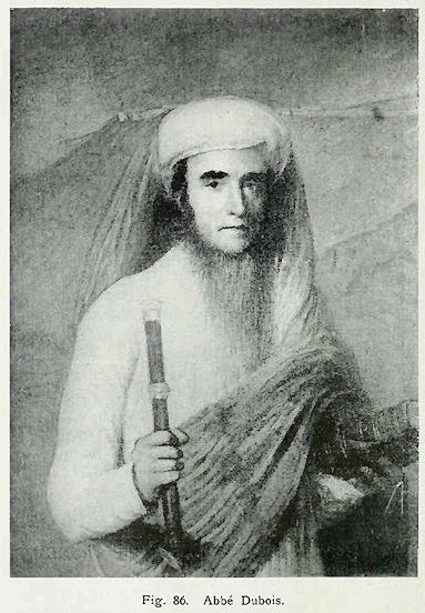
Abb.: Abbé Dubois
[Bildquelle: Thurston, Edgar <1855 - 1935>: The Madras presidency with Mysore, Coorg, and the associated states. -- Cambridge : University Press, 1913. -- xii, 293 S. : Ill. ; 23 cm. -- (Provincial geographies of India). -- S. 240. -- Online: http://www.archive.org/details/provincialgeogra03holluoft. -- Zugriff am 2008-06-21. -- "Not in copyright."]
Of Christian missions to Mysore, the oldest by far was the Roman Catholic. So far back as 1.525 the Dominicans are said to have commenced work in the Hoysala kingdom. In 1400 they built a church [S. 205] at Anekal1. The Vijayanagar Dīwān in 1445 is said to have been a Christian, and also the viceroy at Seringapatam in 1520. In 1587 the Franciscans arrived on the scene. But it was not till the middle of the seventeenth century that mission work was firmly established. At that period some Jesuit priests from Coimbatore founded the Kanarese Mission at Satyamangalam, Seringapatam, and other places in the south. In 1702 two French Jesuits from Vellore founded a Telugu mission in the east, building chapels at Bangalore, Devanhalli, Chik-Ballāpur, and other places. The suppression of the Jesuit Order in 1773 was a severe check; and in the time of Tipū all the churches and chapels were razed to the ground, except one at Grāma near Hassan, and one at Seringapatam, the former being preserved by a Muhammadan officer, and the latter defended by the native Christian troops under their commander. After the fall of Seringapatam in 1799 the work was taken up by the Foreign Missions Society of Paris, and the Abbé Dubois, who was in the south, was invited to Seringapatam by the Roman Catholics. He laboured in Mysore for twenty-two years, adopting the native dress and mode of living. He was highly respected by the people, who treated him as a Brāhman, and he became well-known from his work on Hindu Manners, &c., the manuscript of which was bought by the British Government2. He was the founder of the church at Mysore, and of the Christian agricultural community of Sathalli near Hassan, and is said to have introduced vaccination into the State. The East India Company gave him a pension, and he died in France in 1848 at the age of eighty-three. In 1846 a Vicar Apostolic was appointed, and in 1887 Mysore was made a Bishopric. The Roman Catholics have 98 places of worship in the State. At Bangalore they maintain a high-grade college and college classes for girls, a convent with schools, a well-equipped hospital, orphanages and Magdalen asylum, and a Home for the Aged under the Little Sisters of the Poor ; and at Mysore there are a convent and various schools. Agricultural farms for famine orphans have been formed in the tāluks bordering on Bangalore.
1 An old inscription, surmounted by a cross, has been found there relating to the kumbāra ane or potters' dam,
2 The best and most authentic edition of this work was published at Oxford in 1897, edited by the late H. K. Beauchamp.
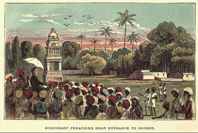
Abb.: Predigender Missionar
[Bildquelle: Hodson, Thomas: Old Daniel or: Memoir of a converted Hindoo, with observations on the mission work in the Gobbe Circuit, and description of village life in India. -- London: Wesleyan Conference Office, [1877?]. -- S. 32. -- Online: http://www.archive.org/details/olddanielormemoi00hodsiala. -- Zugriff am 2008-06-22. -- "Not in copyright."]
Of Protestant missions the first to the Kanarese people was that at Bellary established by the London Missionary Society, which in 1820 was extended to Bangalore. The first dictionaries of the language, and the first translation of the Bible into the vernacular, together with the first casting of Kanarese type for their publication, were the work of this mission. They were also the pioneers of native female education, in 1840. They have Kanarese and Tamil churches at Bangalore, [S. 206] a high school, and various schools for girls. The out-stations are to the east and north of Bangalore, the chief being at Chik-Ballāpur. The Wesleyan Mission began work in 1822, but only in Tamil, in the cantonment of Bangalore. Their Kanarese mission was commenced in 1835. In 1848 a great impetus was given to the publication of vernacular literature by their establishment of a printing press at Bangalore, and the vast improvements introduced in Kanarese type. The mission has now about forty circuits in Bangalore, Mysore, and the principal towns, with high schools at those cities, and numerous vernacular schools all over the country, besides hospitals for women and children at Mysore and Hassan. They also have some industrial schools, and issue a Kanarese newspaper and magazine. The Church of England has a native S.P.G. mission at Bangalore, taken over in 1826 from the Danish Lutherans, by whom it had been begun a few years earlier; and the Zanāna Mission of the Church has a large Gosha hospital (for women) there, with a branch hospital at Channapatna, and a station at Mysore city. The American Methodist Episcopal Church began work in 1880, and has places of worship and schools in Bangalore, chiefly for Eurasians, and a native industrial school at Kolār. A Leipzig Lutheran mission was established at Bangalore on a small scale in 1873 ; and there is a small Faith mission at Malavalli in Mysore District.
The occupations of the people have been returned under eight main classes. Of these the most important are : pasture and agriculture, which support 68 per cent. of the population ; preparation and supply of material substances, 11 per cent. ; and unskilled labour not agricultural, 9 per cent. Actual workers number 1,875,371 (males 1,485,313, females 390,058), and dependents number 3,664,028 (males 1,311,711, females 2,352,317).
Rāgi (Eleusine coracana) is the staple food of all the lower orders and labouring classes. The flour is made into a kind of pudding called hittu, and into cakes, which are fried in oil. Of other millets, jola (Sorghum vulgare) is the most commonly eaten, especially in the north. Puddings and cakes are made of the flour, and it is also boiled whole to eat with curry. Of pulses, avare (Dolichos Lablab) is the favourite, and is used in curries. Rice (Oryza sativa) of many varieties is the principal food of Brāhmans and the higher classes.
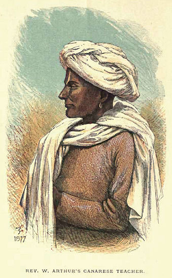
[Bildquelle: Hodson, Thomas: Old Daniel or: Memoir of a converted Hindoo, with observations on the mission work in the Gobbe Circuit, and description of village life in India. -- London: Wesleyan Conference Office, [1877?]. -- Frontispiece. -- Online: http://www.archive.org/details/olddanielormemoi00hodsiala. -- Zugriff am 2008-06-22. -- "Not in copyright."]
White or coloured cotton stuffs of stout texture supply the principal dress of the people, with a woollen kambli or blanket as an outer covering for the night or a protection against cold or damp. Brāhmans go bare-headed, the head being shaved all except the tuft at the crown, and most Hindus observe the same practice. The moustache is the only hair worn on the face. The dhotra, a thin sheet, covers the lower limbs, one end being gathered into folds in front and the other [S. 207] passed between the legs and tucked in at the waist behind. A similar garment is thrown over the shoulders. A bright magenta worsted cap and a scarlet, green, or blue blanket are often worn in the early morning or on a journey. At office, Brāhmans wear a turban and a long coat, either woollen or cotton. Students wear a sort of smoking-cap instead of a turban. The ryots are generally content with a turban and a kambli, with commonly a short pair of drawers. When not at work they often wear a blouse or short smock-frock.
The dress of the women is graceful and becoming. A tight-fitting short bodice is universally worn, leaving the arms, neck, throat, and middle bare, the two ends being tied in a knot in front. It is generally of a gay colour, or variegated with borders and gussets of contrasting tints, which set off the figure to advantage. In the colder tracts, to the west, a somewhat loose jacket, covering all the upper part of the body and the arms, is worn instead. The shīre or sārī, a long sheet, ordinarily dark blue or a dull red with yellow borders, is wrapped round the lower part of the body, coming down to the ankles. One end is gathered into a large bunch of folds in front, while the other, passed across the bosom and over the head, hangs freely over the right shoulder. In the west it is tied there in a knot. Brāhman women pass the lower end of the cloth between the legs and tuck it in at the waist behind, which leaves the limbs more free. Their heads too are not covered, the hair being gathered into one large plait, which hangs straight down the back, very effectively decorated at the crown and at different points with richly chased circular golden cauls or bosses. Vaisya women are similarly dressed, but often with less good taste. They smear themselves with saffron to produce a fair or yellow tint, and not only on their cheeks but also over their arms and legs. This practice, so common among the trading class, is by no means attractive, nor is the habit of blackening the teeth, adopted by married women, more pleasing to European ideas. Many fair women are elaborately tattooed on the arms. Sūdra women generally gather the hair into a chignon or bunch behind, stuffed out with a bunch of wool, and run a large pin through, with an ornamental silver head, which is rather becoming. In the Malnād the women often arrange the back hair in a very picturesque manner, with a plait of the cream-white ketaki flower (Pandanus odoratissimus), or with orchid blossoms or pink cluster-roses. Ornaments are commonly worn by all classes in the ears and nose, and on the arms, with rings on the fingers and toes, and as many and costly necklets and chains round the neck as means will allow. Chains frequently connect the upper rim of the ear with the ornamental pin in the back hair, and have a pretty effect. The richer Brāhman and other girls wear silver anklets, often of a very ponderous make, which are by no means elegant. A silver zone [S. 208] clasped in front is a common article of attire among all but the poorer women, and gives a pleasing finish to the costume. The only marked difference is in the dress of Lambāni women, already described in treating of them.
In Manjarābād the dress of the headmen is usually a black kambli or blanket, passed round the body and fastened over the left shoulder, leaving the right arm free. The waist is girded with a similar article, or with a cloth, generally dark blue with a white stripe. The turbans are mostly white, or dark blue with a narrow gold edging. The labourers have a similar dress of coarser material, and usually wear a leathern skull-cap. All classes carry a big knife, fastened to the girdle behind.
The dress of Muhammadan males differs from that of the Hindus chiefly in cut and colour, and in the wearing of long loose drawers. But for undress a piece of dark plaided stuff is worn like the dhotra. They shave the head completely, but retain all the hair of the face. A skull-cap is worn, over which the turban is tied in full dress. The women wear a coloured petticoat and bodice, with a large white sheet enveloping the head and the whole person, and pulled also over the face.
The higher caste Hindus wear leathern slippers, curled up at the toe and turned down at the heel ; the labouring classes wear heavy sandals, with wooden or leathern soles and leathern straps. Muhammadans also wear the slipper, but smaller, and frequently a very substantial big shoe, covering the whole foot. Women are never shod, except occasionally on a journey, or in very stony places, when they sometimes wear sandals.
Religious mendicants appear in a variety of grotesque and harlequin costumes, with hair unshorn. But garments dyed with red ochre or saffron are the commonest indications of a sacred calling.
The dwellings of the people are generally of mud, one-storeyed and low, with few, if any, openings outwards except the door, but possessed of courtyards within, surrounded with verandas and open to the sky. In the better class of houses these are well paved and drained, while the wooden pillars are elaborately carved or painted. The huts of the outcaste and poorer classes are thatched ; but the houses of the higher orders are covered with either terraced or tiled roofs, the latter more especially in the west, where the rainfall is heavy.
Animal fights, between rams, cocks, and quails, are popular. Companies of tumblers, jugglers, snake-charmers, &c., wander about and earn a living. Theatrical performances are also well patronized. In the south they take place in the open at a certain season in all the large villages, the performers being the villagers themselves. The Hindu festivals most generally observed by all sects are the Holī and [S. 209] the Dasara, which respectively marrk the seasons of the vernal and autumnal equinox ; the Pongal, at the time of the winter solstice, a sort of harvest festival; the Dipāvali or feast of lights; and the Yugādi or new year's day. The Sivarātri, or watch-night of fasting, is kept by all adherents of Siva. The Muhammadans keep the Ramzān, when thirty days of abstinence are observed, and also the Muharram, properly a season of lamentation, but generally kept here as a festival. Their other principal public feasts are the Bakr-īd and Shab-i-barāt.
Among respectable Hindus a man generally has three names—the first being that of his village or the place of origin of his family ; the second his personal name ; and the third that of his caste or sect. It is a common custom to name the eldest son after his paternal grandfather, and the next after his maternal grandfather, but only if they are dead. If they are living, then after the great-uncle or other corresponding near relative who is dead. Girls are similarly named after the female grandparents, &c. But if a child was born in response to a religious vow, it is named after the god who is supposed to have granted it. Muhammadans are named after the apostle under whose star they are born, or from one of the ninety-nine sacred names, to which is added the sect. Girls are named after the wives or female relatives of the apostles.
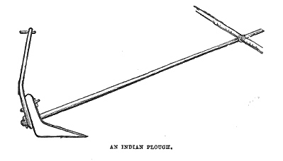
Abb.: Indischer Pflug
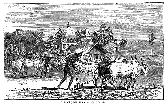
Abb.: Pflüger in Mysore
[Bildquelle beider Abb.: Hodson, Thomas: Old Daniel or: Memoir of a converted Hindoo, with observations on the mission work in the Gobbe Circuit, and description of village life in India. -- London: Wesleyan Conference Office, [1877?]. -- S. 24f. -- Online: http://www.archive.org/details/olddanielormemoi00hodsiala. -- Zugriff am 2008-06-22. -- "Not in copyright."]
Agriculture is chiefly dependent on the rains. If they are sufficient and seasonable, it prospers ; but such a favourable conjuncture is only occasional. 'Wet crops' irrigated from river channels or perennial wells, and products of the self-sustaining black soil, are therefore least affected by vicissitudes of the seasons.
The soils in Mysore vary from black cotton to light sandy loam. A red-coloured loam, or clay loam, predominates. Differing from other soils of India, they are generally deficient in phosphoric acid, most of them containing less than 0.1 per cent. and the average containing barely 0.05 per cent. The percentage of potash is much higher, averaging three or four times that of phosphoric acid. In the hilly virgin-forest region in the west of the State, where coffee is largely grown, the percentage of nitrogen is very high, averaging more than 0.2 percent, in the surface soil and nearly 0.15 per cent. in the second foot. In the eastern portion of the State, where the land has been cultivated a long time, less nitrogen is found. The surface is generally undulating (though flat in some parts and very hilly in others), here and there broken up by rocky hills and gravelly ridges. The annual rainfall varies from about 200 inches in the Western Ghāts to about 25 or 30 inches in the eastern part of the State. Excepting rice, coffee, cardamoms, pepper, areca-nut, and betel-leaf, very little cultivation is carried on in the forest region of heavy rainfall in the [S. 210] extreme west. The other part of the State, with a rainfall varying from about 20 to 60 inches, grows principally rāgi, jola, various pulses and oil plants on the 'dry' lands, with cotton and tobacco in some localities, and principally rice and sugar-cane on the irrigated fields1.
1 This paragraph was contributed by Dr. A. Lehmann, Agricultural Chemist to the Government of Mysore.
The population engaged in and dependent on agriculture, according to the Census of 1901, is 3,657,462, or 66 per cent. of the total. Of these, 951,056 males and 179,876 females are actual workers, and 941,867 males and 1,584,663 females are dependents.
The staple food-grains are : rāgi (Eleusine coracana), rice (Oryza sativa), jola (Sorghum vulgare), other millets (Pnicum), gram (Dolichos biflorus), and other pulses. Oilseeds include gingelly (Sesamum) and castor (Ricinus) ; the chief fibres are cotton and san-hemp ; among spices may be mentioned chilli or capsicum, ginger, coriander, cumin seed, &c. ; and among miscellaneous crops—tobacco, mustard, onions, garlic, &c.
The months for sowing the principal crops are June and July, and November is the general harvest time ; but the pulses avare and togari, which are sown along with rāgi, ripen two or three months later. Horse-gram is sown in October or November, and ripens in three months. Of rice there are two crops, the Kārtika fasal, or kār, maturing in October or November, and the Vaisākha fasal, or hain, maturing in April or May. The ordinary sugar-cane is planted about April and takes twelve months to mature. Other kinds are planted in August or February, and require fourteen months. Cotton is sown in June and ripens in six months, continuing to yield for four months, and the second year's crop is better.
Kumri or shifting forest cultivation is practised only by wild hill tribes in the west and south, and is permitted in some parts under certain restrictions. Under this system jungle is burnt down and seed planted in the ashes.
Agricultural implements in general are such as have been in use for ages. The principal new appliance that has been to some extent adopted is an iron mill for expressing the juice of the sugar-cane, which has in many parts replaced the old cumbrous apparatus.
Fruit and vegetable production has received special attention in the neighbourhood of Bangalore. Apples, strawberries, potatoes, peas, and cauliflowers may be mentioned among European products that are well established. Of native fruits, the grafted mango is largely cultivated. Areca-nuts, coco-nuts, and plantains are general in irrigated land. The best areca-nuts are a special production of Nagar and the moist west. Coco-nuts are grown without irrigation in the central parts of the State, and the dried kernels are an article of export. A horticultural garden [S. 211] is maintained by the State in the Lāl Bāgh at Bangalore, and an exotic fruit garden at Nandidroog. Native florists do a good business in plants.
To the Agricultural department are attached an agricultural chemist, with assistants, a mycologist, and an entomologist. A well-equipped chemical laboratory has been fitted up at Bangalore, where analyses are made of soils, of the composition of manures and fertilizers, of the quality of special products like coffee, and of roots, bulbs, and other wild edibles that may be of use as food in time of famine. Prevalent insect pests and plant diseases are investigated with a view to devising remedies. Plot experiments are being conducted in the cultivation of sugar-cane, rāgi, sweet potatoes, and ground-nuts. A plant-house for pot culture is being erected. An experimental farm has been formed near Bangalore, where 'wet' and 'dry crops' are being raised. In the Lāl Bāgh garden at Bangalore rubber, fibre, and cotton plants are receiving attention. At the Kunigal stud farm special kinds of rice are being tried. Arrangements have been made for imparting instruction in practical agriculture at the normal school in Mysore and at eight other State schools, and in sericulture at Mr. Tata's silk farm in Bangalore. Moreover, a few model holdings in each tāluk are being selected by the amaldārs, belonging to intelligent tenants who are willing to cultivate them on improved methods according to expert advice. Agricultural shows are to be held at the District head-quarters and prizes awarded by the State.
Loans for land improvement during the thirteen years ending 1903-4 amounted to a total of 1.6 lakhs. In the same period 7.1 lakhs was also advanced for 3,068 irrigation wells, of which 2,212 were completed. For. sāgūvali kattes or cultivation embankments Rs. 1 1,000 was advanced.
There were fifty-nine agricultural banks in 1904, of which twenty-one were reported to be working satisfactorily, but taken altogether they have not been a success. Two banks intended for the benefit of native coffee-planters had received loans up to nearly 9 lakhs, of which more than 3½ lakhs was outstanding. They have since been closed, and individual contracts for repayment made with the estates which had received loans. The advances to the remaining banks had amounted to 7½ lakhs, of which 1 lakh was recovered. Owing to lax management thirteen banks have had the advances made to them recalled. The loans granted by the banks, exclusive of renewals, amounted to 10¾ lakhs, of which 7 lakhs was used to liquidate previous debts, and the rest for agricultural purposes. The balance due to the State in 1904 for loans and interest was 13 lakhs.
The cultivators are for the most part in debt, but not heavily, their liabilities generally ranging between Rs. 50 and Rs. 100. In villages [S. 212] the creditors are, as a rule, themselves agriculturists, but in towns they are more often money-lenders. The rate of interest on private loans to agriculturists varies. In some places in the Malnād the rate till recently ranged between 24 and 36 per cent. In other tracts it used to be 18 per cent. The rate is now everywhere lower, the minimum being 12 and the maximum 18 per cent. A Co-operative Societies Regulation was passed in 1905, from which good is anticipated.
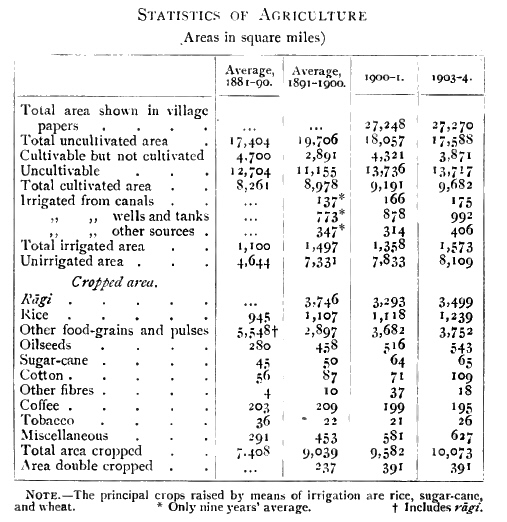
The Amrit Mahāl is the principal cattle-breeding establishment. Its head-quarters are at Hunsūr, and grazing-grounds called kāvals are reserved for its use in different parts of the country. In 1903-4, with 9,686 head of cattle, the births were 42.5 per cent. on the average number of breeding cows, and the deaths 9.3 per cent. on the total stock. The sales, including 150 young bullocks to the Madras Transport Depot at the usual rate of Rs. 50 each, realized an average of Rs. 36 per head. Amrit Mahāl bullocks are famed for their pluck and endurance, being as superior to others as thoroughbreds among horses. The best breed is the Hallikār. The ordinary cattle are of the Mādesvaran-betta and Kānkānhalli breeds, both named from places in the south-east of the State. Amrit Mahāl bulls are stationed by [S. 213] Government in various parts for improving the breed of cattle used by the ryots. Six Amrit Mahāl cows were sent to the Chin Hills in Northern Burma to be crossed with mithan bulls (Bos frontalis). Large cattle fairs are held at Nandi, at the ghāt north of Dod-Ballāpur, at Santemāranhalli, and other places. An ordinary pair of plough bullocks costs from Rs. 30 to Rs. 50 or more : superior trotting and draught-bullocks, Rs. 70 to Rs. 200 or more. Buffaloes are extensively used for supplying milk, and for carrying manure and ploughing in heavy land.
Sheep and goats were kept on farms under the Amrit Mahāl dārogas. In 1902, with 1,694 head, there were 308 births and 294 deaths. Owing to similar poor results over a series of years, the flocks were then sold, only 257 sheep of Australian and Kashmīr breeds being retained. The ordinary country sheep are the Kurubar. They are shorn twice a year, and the wool is made into rough kamblis. Fine fighting rams are produced. Sheep are folded on fields for the sake of their dung, which is highly valued.
The stud farm is at Kunigal. In 1904 there were five stallions, 81 brood mares, and 200 foals, of which 35 were born in the year. Good native cavalry remounts are produced. From Kathiāwār three wild asses (Equus hemionus) were obtained in order to breed a larger type of donkeys in the State, and for mule-breeding, for which there is a farm near Devanhalli.
The principal cattle diseases are anthrax, foot-and-mouth disease, malignant catarrh, and lung diseases. Rinderpest has also been known. There is a civil veterinary officer only for Bangalore ; but the natives have their own remedies and methods of treatment, among which cautery or branding with hot iron is very common.
The sources of irrigation are channels drawn from dams on the rivers, besides tanks and wells. The most important of the river channels are in the south of the State, connected with the Cauvery and its tributaries. Most of them were originally constructed centuries ago, but have been improved and extended. The water is let out according to the needs of the rice or sugar-cane crops, and confined to the proper seasons for them. To put an end to complaints of unequal distribution, the management of the river channels in the irrigation season was in 1888 put under the amaldārs of the tāluks through which they run, and the hot-season supply to sugar-cane and garden tracts was arranged to be given at fixed periods, in consultation with the Deputy-Commissioners concerned. There is no separate water rate, but the fixed assessment includes the full value imparted by soil and water combined. The value of the channel water-supply is determined on the basis of quantity, duration, and facility, according to the established capacity of each channel. The supply of water from tanks is similarly regulated. The receipts from river-fed channels in 1903-4 [S. 214] amounted to 6½ lakhs, and the net profits to 5 lakhs. The best wells are those throughout the north-east, fed by talpargis or spring-heads. The water is raised by either the yāta or the kapile. The former, also known as picottah, is a lever with an iron bucket attached at the water end by a bamboo rod. The lever is weighted at one end with stones, or else raised and depressed by a man standing on it near the fulcrum post. The kapile has an inclined plane or ramp, down which bullocks draw a stout rope attached to a large leathern bucket.
A very large irrigation work is under construction at Māri Kanave on the Vedāvati. Other prominent recent works for the same purpose are Bora Kanave, Māvatūr tank, Srīnivāsa Sāgara, &c. Various projects in different tracts have been examined.
The general system of land tenure is ryotvāri, under which small separate holdings are held direct from government. There is also a certain number of inām tenures, which are wholly or partially revenue free. In 1904 there were 965,440 ryotvāri holdings, with an average area of 7.11 acres, and an average assessment of Rs. 9-6-1. The inām holdings numbered 84,548, with an average area of 20.8 acres, and an average assessment of Rs. 6-5-0. A special class are the leaseholders of gold-mines, whose holdings numbered 44, with an average area in each estate of 912.5 acres, assessed at an average of Rs. 439-6-7.
The sum payable by the cultivator, which is revenue rather than rent, is determined mainly by the class of soil and kind of cultivation. After the revenue survey, the settlement of this point is effected on the following system. Nine classes of soil are recognized, and all the land is divided into 'dry,' 'wet,' and 'garden' land. In the two latter, in addition to soil classification, the water-supply is taken into consideration, and its degree of permanency or otherwise regulates the class to which it is referred. In the case of gardens irrigated by wells, in addition to the classification of soil, the area of land under each, and the distance of the garden from the village, as affecting the cost of manuring, &c., are carefully ascertained. Villages are grouped according to their respective advantages of climate, markets, communications, and the agricultural skill and actual condition of the cultivators. The maximum rates for each class of cultivation are then determined by reference to the nature and effects of past management of the tāluk for twenty years, and by examination and comparison of the annual settlements of previous years. These having been fixed, the inferior rates are at once deduced from the relative values laid down in the classification scales.
Of measures intended to improve the position of the cultivators and to relieve them from indebtedness, one of the principal has [S. 215] been the collection of revenue in instalments at such times as enable the cultivator to sell his crop first. There is also the recent Cooperative Societies Regulation. Taking the natural divisions of east and west, the average rate per acre in the former in 1904 was Rs. 1-7-3, the maximum and minimum being Rs. 2-1-11 and R. 0-10-8; in the latter, the average was Rs. 1-13-1, the maximum and minimum being Rs. 1-14-1 and Rs. 1-12-5. The batai system, or payment of revenue by division of the crop, which formerly prevailed, has been entirely replaced by cash rates.
The daily wages for skilled labour vary in different parts from 6 annas to Rs. 1-8, and for unskilled labour from 2 annas to 8 annas. While the latter has remained at about the same figure as regards the minimum, with a tendency to rise, the former has increased in the last twenty years from 50 to 100 per cent. Payment in kind is becoming less common, probably owing to the influence of railways, mining and other industries, and large public works, the labourer being less tied down to single localities, and having greater facilities to travel at a cheap rate.
The following table relating to the staple food-grains and salt shows that there has been a general rise in prices, except in the case of salt, which is cheaper :—
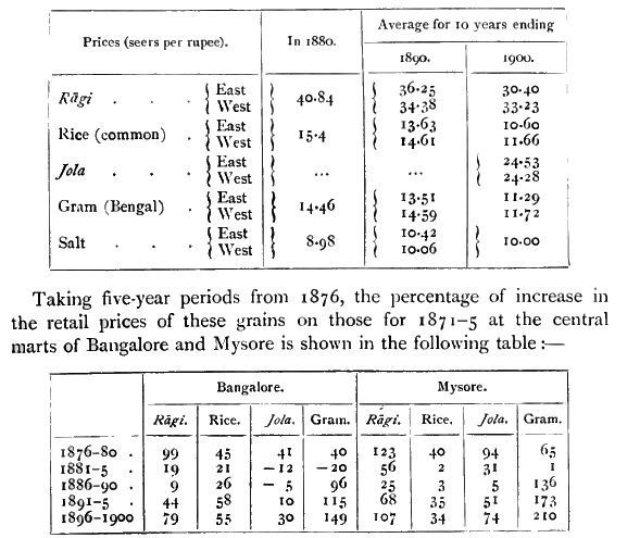
[S. 216] The initial increase was due to the famine of 1876-8. A great drop succeeded till 1895, owing at first to good seasons and diminished population, and later to freer means of communication also. In the last period prices have been rising, owing probably both to short crops locally and to the demand from famine-stricken parts elsewhere, especially in Western India.
The general condition of the people has been steadily improving since the middle of the last century, and has made special progress in the past thirty years, as shown by the rise in both wages and prices, and in the standard of living. A moderate assessment has relieved the cultivators, while the easy means of communication provided by roads and railways, together with freer postal facilities, have stimulated the enterprise of traders and benefited all classes. The prosecution of extensive public works has given labourers and artisans ready employment, and public servants have had exceptional opportunities of rising to good positions. On the other hand, there have been bad seasons in certain years, and in 1876-8 a great famine. Coffee-planting has been almost ruined by the fall in prices. Cardamoms have suffered from the same cause, and areca-nuts have been injured on a large scale by disease. Plague has also in recent years interfered greatly with the well-being of the people. But education and medical aid are now brought to the doors of all classes, and in important centres the population are better housed, better clothed, and better fed than in the generations past.
The area of State forests, which are 'reserved' and are under a Conservator of Forests, was 2,094 square miles in 1904, besides about 1,400 square miles of Ghāt forests and kāns. The unreserved or District forests, which are under the revenue authorities, covered 612 square miles. The forests may be divided into evergreen and deciduous. The evergreen forests are confined to the Western Ghāts and the country below them on the east, extending from the north of Sāgar to the south of Manjarābād, in a belt from 6 to 14 miles wide. On all sides may be seen magnificent trees with clear stems of 80 to 100 feet to the first branch. Poon-spar (Calophyllum tomentosum), ebony (Diospyros Ebetium), and wild jack (Artocarpus hirsuta) are some of the trees. East of this is a mixed belt, from 10 to 45 miles wide, extending from the north of Sorab to the south of Gundalpet. It contains the finest timber-producing forests, and is bordered on the east with much sandal-wood. It also comprises the best areca-nut and cardamom gardens, and the coffee plantations of Koppa and Manjarābād. Its junction with the evergreen belt on the west is marked by splendid nandi (Lagerstroemia lanceolata) and black-wood (Dalbergia latifolia). Teak, satin-wood, sissu, ironwood, and other trees abound in it, as [S. 217] well as bamboo. East again is the dry belt, covering the greater part of the State. Many of the trees found in the mixed belt recur here, but they are smaller, and the tree vegetation is generally inferior. Besides different kinds of Ficus, the mango, tamarind, and jāmun, the ippe (Bassia latifolia), and jack (Artocarpus integrifolia) grow well here. Acacias, the wood-apple, bael-tree, and honge (Pongamia glabra) also thrive. The bastard date-palm (Phoenix sylvestris) grows in the western part, and the dwarf date-palm (Phoenix farinifera) in the centre and west.
There are twelve kinds of 'reserved' trees : sandal-wood (Santalum album), teak (Tectona grandis), poon (Calophyllum tomentosum), blackwood (Dalbergia latifolia), honne (Pterocarpus Marsupium), lac or jālāri (Vatica laccifera), nandi (Lagerstroemia lanceolata), wild jack or hesswa (Artocarpus hirsuta) kārāchi or kammar (Hardwickia binata), bili matti (Terminalia Arjuna), kari matti (Terminalia tomentosa), and ebony (Diospyros Ebenum).
The principal articles of minor forest produce are gall-nuts, tanning bark from tangadi (Cassia auriculata), and lac. Also soap-nuts, gum, honey, beeswax, &c.
Elephants are employed in dragging timber from inaccessible places, and logs are floated down the western streams and channels. Large-sized timber is sold at the regular timber depots, and small-sized timber at temporary depots opened in convenient places. Bamboos are cut by licence. Sandal-wood, which is a State monopoly and the principal item of forest revenue, is sold at the various sandalwood depots.
Fuel reserves are formed in the District forests, and by special plantations, often of casuarina. Local needs are also provided for by the formation of village forests. Grazing is permitted to a certain extent on a system of licences ; but in times of scarcity the State forests are thrown open where necessary.
Working-plans are being prepared for all the most important forests. Fire preventive measures have been extended over 1,823 square miles, of which 1,653 were successfully protected in 1903-4.
The forest revenue, expenditure, and surplus have been as follows :—-
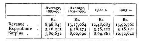
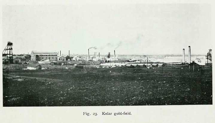
Abb.: Kolār Gold Fields
[Bildquelle: Thurston, Edgar <1855 - 1935>: The Madras presidency with Mysore, Coorg, and the associated states. -- Cambridge : University Press, 1913. -- xii, 293 S. : Ill. ; 23 cm. -- (Provincial geographies of India). -- S. 72. -- Online: http://www.archive.org/details/provincialgeogra03holluoft. -- Zugriff am 2008-06-21. -- "Not in copyright."]
Gold is the only mineral raised from mines. These were being worked by thirteen companies in 1904, of which five paid dividends, [S. 218] three produced gold but paid no dividend, and the rest were non-producers. All but three, which are included in the non-producing class, belong to the Kolār Gold Fields. The ore is treated by milling and amalgamation, and the tailings by cyanide. Steam power has been replaced since June, 1902, by electric power, generated at the Cauvery Falls, 92 miles distant. The number of persons employed in the industry in 1903 was 27,355. Of these, 76 per cent. were Hindus, 18 per cent. Christians, and 6 per cent. Muhammadans. The great majority of the Hindus were Holeyas, the others being mostly Wokkaligas, Tigalas, and Woddas. The Christians consisted of 17 per cent. Europeans, 22 per cent. Eurasians, and 61 per cent. natives. The amount paid in wages was 70.3 lakhs, which gives an average earning of Rs. 257 per head per annum. The five dividend-paying companies are the Mysore, Champion Reef, Ooregum, Nundydroog, and Bālāghāt. The nominal capital of all the companies was £2,958,500, and the paid-up capital £2,683,000. All the gold produced is dispatched to England. Minerals as yet unworked in the State include a small quantity of asbestos. Iron is smelted in several places. Some manganese has lately been exported from Shimoga District.
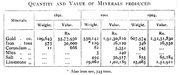
For cotton-weaving the loom is placed over a kind of well or hole, large enough to contain the lower portion of the machinery, which is worked on the pedal principle with the toes, the weaver sitting with his legs in a hole. The combs are supported by ropes attached to beams in the roof, working over pulleys, and stretching down into the well to the toes of the weaver. In his right hand is the shuttle, which contains the thread, and which, passed rapidly through the spaces created by the combs, forms the pattern. The principal comb is held in the left hand. As the cloth is manufactured, it is wound on the beam by slightly easing the rope on the right hand and turning round the lever. In addition to cotton stuffs used for clothing, the [S. 219] principal fabrics made are tape for bedsteads, carpets or rugs, tent cloth, cordage, &c. Steps have recently been taken to introduce the fly-shuttle ; and six weaving-schools for instruction in its use have been established at Hole-Narsipur, Dod-Ballāpur, Chiknāyakanhalli, Molakālmuru, and other places, with carpentry and drawing classes attached.
Silk fabrics of stout texture and excellent designs are made, chiefly by Patvegars and Khattrīs, in Bangalore and Molakālmuru. Women of the wealthier classes are often richly attired in silk cloths on ceremonial or festival occasions. These, with or without gold and silver or gilt lace borders, are largely manufactured at Bangalore ; the silk and wire used for the purpose are also produced in the State. Sericulture is extensively carried on in the Closepet, Kānkānhalli, Māgadi, Chik-Ballāpur, Tirumakūdal-Narsipur, and other tāluks ; but Bangalore is the centre of the silk trade, where raw silk is prepared on a considerable scale for the loom and dyed. There has recently been established here, by the late Mr. J. N. Tata of Bombay, an experimental silk farm under Japanese management for improved systems of silkworm rearing, so as to eliminate disease in the worms by microscopic examination of the seed, and for better reeling. Near Yelahanka is also an improved farm belonging to Mr. Partridge for the scientific rearing of silkworms.
The carpets of Bangalore are well-known for their durable quality, and for having the same pattern on both sides. The old patterns are bold in design and colouring. The pile carpets and rugs made in the Central jail from Persian and Turkish designs are probably superior to any other in India. Sir George Birdwood says1 :—
'The stone slab from Koyundjik (palace of Sennacherib), and the door-sill from Khorsabad (palace of Sargon), are palpably copied from carpets, the first of the style of the carpets of Bangalore, and they were probably coloured like carpets. These South Indian carpets, the Masulipatam, derived from the Abbasi-Persian, and the Bangalore, without any trace of the Saracenic or any other modern influence, are both, relatively to their special applications, the noblest designed of any denomination of carpets now made, while the Bangalore carpets are unapproachable by the commercial carpets of any time and place.'
1 In his splendid book, called The Termless Antiquity, Historical Continuity, and Integral Identity of the Oriental Manufacture of Sumptuary Carpets, prepared for the Austro-Hungarian Government.
Carpets are less used now, and the industry has declined.
Gold circular or crescent-shaped ornaments worn by women on the hair are called rāgate, kyādige, and jede bile. Ornamental silver pins with a bunch of chauri hair for stuffing the chignon or plait are known as chauri kuppe. Ear-rings for the upper rim are named bāvali ; those for the large hole in the lobe, vōle or vāle. A pear-shaped drop worn on the forehead is called padaka. Necklaces include addike and [S. 220] gundina sara. Bracelets are termed kankani; armlets, vanki, nāga-murige, tohi tāyiti, bandi, and bājuband. A zone is dābu. Anklets of silver are luli, ruli, and kālsarpani; little bells for them, worn by children, are kālu gejje. Silver toe-rings are called pilli. Silver chains worn by men round the waist are known as udidhāra. The silver shrine containing the lingam worn by Lingāyats is karadige. Small silver money-boxes attached to the girdle are named tāyiti, while an egg-shaped silver chunām box is sunna kāyi.
Iron is widely diffused, and is obtained both from ore and from black iron-sand. The principal places where iron is smelted are in the Māgadi, Chiknāyakanhalli, Malavalli, Heggadadevankote, and Arsikere tāluks, in the southern and central parts of Chitaldroog District, and in the eastern parts of Shimoga and Kadūr Districts. A steam iron foundry has been established at Bangalore under European management. There are native iron-works at Goribidnūr and Chik-Ballāpur. Sugar-cane mills are made and repaired at Channarāyapatna. The local iron is used for making agricultural tools, ploughshares, tires for cart-wheels, farriery shoes, and so forth. But local manufacture has been driven from the field by the cheaper and better imported articles from Europe, turned out on a large scale with the aid of machinery. Steel of a very high quality can be made ; but the methods used are primitive, and it cannot therefore compete with the highly finished European products of the present day, though it is preferred by the natives for the edge of cutting tools. Steel is made especially in the Heggadadevankote, Malavalli, and Maddagiri tāluks. Steel wire is drawn at Channapatna for strings of musical instruments, the quality of which makes them sought after throughout Southern India.
The manufacture of brass and copper water and drinking vessels is to a great extent in the hands of the Bhogārs, who are Jains, some of the chief seats of the industry being at Sravana Belgola and Sitakal. Brass is also used for making lamp-stands, musical instruments, and images of the gods ; and bell-metal for the bells and gongs used in temples and in religious services, and by mendicants. Hassan and Tumkūr Districts produce the largest number of these articles.
The potter, as a member of the village corporation, is found in all parts, with his wheel and his mounds of clay. The principal articles made are pots for drawing or holding water, large urns for storing grain, pipe tiles, and so forth. For sculpture, potstone or soapstone is the common material; and of this superior cooking vessels are made, besides images of the gods, and various ornamental articles. In the higher departments of sculpture, such as statuary and monumental and decorative carving, Mysore holds a high place. The Jain statue of Gomata at Sravana Belgola, 57 feet high, standing on the summit of a hill which rises to 400 feet, is one of the most remarkable works of native [S. 221] art in India. The decorative sculpture of the Halebīd and Belūr temples Mr. Fergusson considers to be 'the most marvellous exhibitions of human labour to be found even in the patient East,' and such as he believes never was bestowed on any surface of equal extent in any building in the world. The erection of the new palace at Mysore is affording an opportunity of reviving the artistic skill of the sculptors.
Mysore is famous for its ornamental sandal-wood carving. This is done by a class called Gūdigar, who are settled in Shimoga District, chiefly at Sorab. The designs with which they entirely cover the boxes, desks, and other articles made are of an extremely involved and elaborate pattern, consisting for the most part of intricate interlacing foliage and scroll-work, completely enveloping medallions containing the representation of some Hindu deity or subject of mythology, and here and there relieved by the introduction of animal forms. The details, though in themselves often highly incongruous, are grouped and blended with a skill that seems to be instinctive in the East, and form an exceedingly rich and appropriate ornamentation, decidedly Oriental in style, which leaves not the smallest portion of the surface of the wood untouched. The material is hard, and the minuteness of the work demands the utmost care and patience. Hence the carving of a desk or cabinet involves a labour of many months, and the artists are said to lose their eyesight at a comparatively early age. A number are being employed on work for the new palace at Mysore. Many old Hindu houses contain beautiful specimens of ornamental wood-carving in the frames of doors, and in pillars and beams. The art of inlaying ebony and rosewood with ivory, which seems to have been cultivated by the Muhammadans, and of which the doors of the mausoleum at Seringapatam are good examples, has lately been revived at Mysore, and many useful and ornamental articles, such as tables, desks, album covers, &c., are now made there of this work. Similar inlaying is also met with in choice musical instruments, especially the vīna or lute.
Coffee-works at Bangalore, owned by a Madras firm, peel, size, and sort coffee berries in preparation for the European market. During the cleaning season, December to March, about 1,000 hands have been employed, and 1,500 tons of coffee, the produce of Mysore, Coorg, the Nīlgiris, Shevaroys, &c., once passed through the works. The present depression in coffee has reduced these figures to about a fourth. The factory is also engaged in compounding artificial manures for coffee plantations. There are other similar coffee-works at Hunsūr, as well as saw-mills. A Madras firm has a cotton-ginning factory at Dāvangere. A sugar factory has been established at Goribidnūr, and a brick and tile factory at Bangalore, for machine-made bricks and tiles, fire-bricks, drain pipes, &c. Mention has already been made of the iron foundry at Bangalore, and of the silk farm. [S. 222]
The Mysore Spinning and Manufacturing Company at Bangalore was established in 1883, and is under the management of a Bombay Pārsī firm. The nominal capital is Rs. 4,50,000. The mill contains 187 looms and 15,624 spindles, and employs 600 hands. The Bangalore Woollen, Cotton, and Silk Mills Company at Bangalore was established in 1888, and has a capital of Rs. 4,00,000. It contains 14,160 spindles for cotton, and 26 looms and 780 spindles for woollens. The number of hands employed varies from 500 to 600. In 1903-4 the out-turn was 173,000 lb. of grey goods; 52,000 dozen of other goods; and 1,555.000 lb. of yarn.
Oil-mills are at work in Bangalore. Oil-pressing from the various oilseeds grown in the country is the special calling of the class called Gānigas, who are found in all parts of the State. The number of private native mills was returned as 2,712 in 1904. Concessions for the distillation of the valuable sandal-wood oil are granted by the State.
Tanneries on a considerable scale are managed by Muhammadans in Bangalore, where hides are well cured and prepared for export to European markets.
The only breweries are situated in the Civil and Military Station of Bangalore. Three supply the various beer taverns at Bangalore and the Kolār Gold Fields with what is called 'country beer.' The fourth makes a superior beer for the soldiers' canteens in barracks.
The extension of railways and the opening out of roads have greatly increased the facilities for trade. So far as the figures can be relied on, the value of exports is about double that of imports. The most valuable imports are grain and pulse, articles of iron and steel, raw silk, piece-goods, tobacco, and cotton thread. The chief exports, next to gold, are grain and pulse, betel-leaf, areca-nuts, raw silk, sugar and jaggery, coffee, and coco-nuts, chiefly the dried kernels. Among imports, tobacco trebled during the ten years ending 1901. Among exports, while gold increased nearly 100 per cent., coffee fell 44 per cent. The export of sugar and jaggery and of coco-nuts (dry and fresh) doubled, while that of betel-leaf quadrupled.
The principal Hindu trading classes of the country are Banajigas, Komatis, and Nagartas ; after whom come the Tamil Mudalyārs and Musalmāns. The traffic in grain is not entirely in the hands of traders, for the ryots themselves are in the habit of clubbing together and sending off one or two of their number to deal in grain at any convenient market or fair. Apart from the railway, the common mode of carriage and transport is by country carts, the ordinary load of which exceeds half a ton, drawn by bullocks which go 18 to 20 miles a day. But in remote forest tracts and the hills, droves of pack-bullocks and asses are still used, the carriers being generally Lambānis or Korachas. [S. 223] Trade outside the State, excepting for gold and coffee, which are sent to England, is chiefly confined to the surrounding British Districts. Gold goes via Bombay, coffee generally by way of Mangalore or Marmagao, the producers in both cases being, with hardly an exception, Europeans. The principal trading centres in the State are noted under their respective Districts. A Bangalore Trades Association has been formed, chiefly among the European shopkeepers in the Civil and Military Station.
The following table gives statistics of the total value (in thousands of rupees) of imports and exports. The total value of the rail-borne trade alone is given as—in 1890-1, imports 2.5 crores, exports 2.8 crores ; in 1900-1, imports 3.8 crores, exports 3.4 crores. Details are not available.
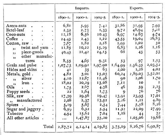
The system of railways
radiates from Bangalore, and there is no District without a railway running
through some part of it. The Bangalore
branch of the Madras Railway, standard gauge, runs for 55½ miles in the State,
east from Bangalore city to Bowringpet, then south-east to the main line at
Jalārpet. From Bowringpet the Kolār Gold Fields branch, 10 miles in length, on
the same gauge, runs first east and then south to the end of the Mysore
Minefield. The Southern Mahratta Railway, metre gauge, runs southwest through
Mysore to Nanjangūd, and north-west through Harihar [S. 224] towards Poona, for 312 miles in the State.
From Yesvantpur a branch, 51 miles in the State, runs
north through
Hindupur to Guntakal on the Madras Railway. From Birūr a branch, 38
miles long, runs north-west to Shimoga. Surveys have
been made to extend the line from Nanjangūd south-east to Erode on the Madras Railway,
and also for a 2½ feet gauge line to the west coast, either from
Arsikere to Mangalore, 86 miles in the State, or from Mysore to
Tellicherry, 58 miles in the State. The Southern Mahratta Railway Company has
proposed a metre-gauge line from Mārikuppam in
Kolār District to
Dodbele station in Bangalore District, in order to provide direct
communication between the Gold Fields and the port of Marmagao ; and
the survey for it is being made. A light railway on the 2½ feet gauge,
from Bangalore north to Chik-Ballāpur, 36 miles, is projected by a
private company.
The total length of line open in 1891 was 367 miles, of which 55½ were standard gauge, and the rest metre gauge. In 1904 the total was 466½ miles, the addition being all metre gauge. The Kolār Gold Fields branch is worked by the Madras Railway; the remaining Mysore State lines by the Southern Mahratta Railway on short-term agreements. For the Mysore-Harihar line the Southern Mahratta Railway Company raised a loan on a guarantee of 4 per cent. interest by the Mysore State, which also pays to the company one-fourth of the surplus profits.
The capital outlay on all the lines owned by the Mysore State up to 1904 is 2.3 crores, of which 1.6 crores was incurred on the Mysore-Harihar line. The number of passengers carried in 1903-4 was 2½ millions. The total expenditure was 7.7 lakhs, and the net earnings 7 lakhs. The Kolār Gold Fields and the Bangalore-Hindupur lines were the only two that showed a surplus, after deducting 4 per cent. for interest on the capital outlay.
The railways were expressly designed to serve as a protection against times of scarcity; and since the great famine of 1876-8, when the only railway was the Bangalore branch of the Madras Railway as far as the cantonment, the pressure of severe distress has been averted. Prices have no doubt tended to become equalized. It is not known that any change in the language or customs of the people has arisen from the extension of railways.
Trunk roads run through all the District head-quarters to the frontiers of the State, connecting the east coast and adjoining British Districts by way of the Mysore table-land with the west coast. In 1856 there were 1,597 miles of road in the State. Besides the construction of new roads, improvements in the alignment of old ones, provision of bridges across rivers, and other measures to ensure free transit have since been continuously carried out. A good system of local roads radiates from each District head-quarters to all parts of the [S. 225] District. The previously almost inaccessible Malnād tracts in the west were the last to benefit, but these were generally opened up by about 1870. Much attention has also been paid to improving the ghāt roads through the passes in the mountains to the west. As railways have extended, feeder roads have been made in those parts where none existed.
The old style of carts had a solid wooden wheel. They are known as Wodda carts, and are still employed at quarries for the transport of stone. But for general purposes they have long been superseded by carts with spoked wheels, but without springs. These take a load of over half a ton, and are drawn by a pair of bullocks. In the western parts a broad wain, drawn by several pairs of bullocks, is used for harvesting purposes.
In 1891 there were 1,730 miles of Provincial roads and 3,113 miles of District or Local fund roads. In 1904 the figures were 1,927 miles of Provincial roads, costing for upkeep an average of Rs. 199 per mile ; and 3,502 miles of District or Local fund roads, maintained at an average cost of Rs. 72½ per mile.
A steam tramway is proposed for 18 miles from Shimoga for the transport of the manganese ores that are being collected there.
Owing to either rocky or shallow beds, none of the Mysore rivers is navigable, nor are there any other waterways for such use.
The old postal system of Mysore, called the Anche, dates from the time of Chikka Deva Rājā in the seventeenth century. In 1889 it was amalgamated with the British postal service and the entire management transferred to that department, on condition of all the official correspondence of the State being carried within the limits of the State free of cost to the Darbār. There is no doubt that the change has been on the whole for the benefit of the public. For postal services Mysore is now a part of the Madras circle. In 1904 there were 428 post offices, and the mails were carried over 2,645 miles. The number of letters delivered was 7 millions, of post-cards 5 millions, of newspapers 650,000, of packets 660,000, and parcels 150,000. The value of money orders issued was 53 lakhs. In the Post Office savings banks 38,586 persons deposited 10.12 lakhs, and 9.18 lakhs was drawn out.
In the Mysore State savings banks there were 20,214 depositors in 1903-4. The opening balance of 73¾; lakhs was raised by deposits (34 lakhs) and interest to no lakhs, of which 31 lakhs was paid out in the year, leaving a balance of 79 lakhs at credit of the depositors.
The Mysore State Life Insurance scheme was instituted in 1892, and made obligatory on officials. Up to 1904 there had been issued 7,423 policies, assuring 44½ lakhs. Of this number 6,762 remained effective, [S. 226] assuring 40 lakhs. The second quinquennial valuation of the assets and liabilities of the Fund, made by an actuary in Edinburgh in 1902, confirmed its sound condition and the favourable nature of its terms.
Failure of the rains for three seasons in succession brought about the famine of 1876-8, and, in general, failure of the rains in any part is the main cause of famine. Those parts which receive the least rainfall are therefore the most liable to suffer: namely, Chitaldroog District, and the northern parts of Tumkūr, Bangalore, and Kolār Districts.
Rāgi is the staple food of all the labouring classes, and if this crop fails there is widespread distress. A remedial measure is the raising of crops of jola on the dry beds of tanks, but this is only a partial palliative. If the rāgi season has passed, horse-gram is more extensively sown for human food, but this will not mature without some rain. Rāgi used formerly to be stored in underground pits, where it would keep good for ten years, to be brought out for consumption in times of scarcity. But the inducements now presented by high prices elsewhere and cheap means of transport have interfered with the replenishment of such stores, and consequently there is less resource of that kind to fall back upon. Rice, which is the main irrigated crop, is not much eaten except by Brāhmans, but always commands a ready sale for export.
The information about famines due to drought previous to that mentioned above is very scanty, but dreadful famines followed the devastations of the Marāthā armies and the wars with Mysore at the end of the eighteenth century. During the invasion of Lord Cornwallis, when, as Buchanan-Hamilton says, the country was attacked on all sides and penetrated in every direction by hostile armies, or by defending armies little less destructive, one-half at least of the inhabitants perished of absolute want. In the last century periods of scarcity occurred in 1824, 1831, and 1833. The ten years following 1851 were a time of great trial, when year after year the sparse and ill-timed rainfall kept the agricultural classes in constant dread of actual want. Two or three seasons ensued which were prosperous, but in 1866 famine was again present in Chitaldroog and the north-eastern parts of the State.
Bad, however, as these seasons were, and critical as was the condition of the country, the misfortune which was to come put them completely in the shade. The failure of rain in the years 1875-7 brought about a famine such as was never known before. The beginning of the calamity was the partial failure of the rains in 1875, the fall being from one-third to two-thirds of the average. Much of the food-crop was lost ; but owing to the usual large stocks in the State, only temporary or occasional distress was caused, for the price of grain did [S. 227] not rise to double the ordinary rates. In 1876 the rainfall was again very short, and barely a third of the ordinary harvest was reaped. Matters were aggravated by the fact that crops had failed in the adjacent Districts of Madras and Bombay ; and by the middle of December famine had begun. From then till March matters grew worse. The only railway, from Madras to Bangalore, brought in daily 500 tons of food (enough to support 900,000 people), yet the prices of food ranged during those months at four to five times the ordinary rates. In April and May, 1877, the usual spring showers fell, and hope revived. But as the month of June wore on and July came, it was apparent that the early rains were going to fail again, for the third year in succession. Panic and mortality spread among the people ; famine increased and became sore in the land. In May 100,000 starving paupers were being fed in relief kitchens, but by August the numbers rose to 227,000, besides 60,000 employed on the railway to Mysore city. It became evident that the utmost exertions of the local officers were unequal to cope with the growing distress. The Viceroy, Lord Lytton, visited Mysore, and appointed Mr. (now Sir) Charles Elliott as Famine Commissioner, with a large staff of European assistants. Relief works were now concentrated, and gratuitous relief was confined to those whose condition was too low to expect any work from them at all. Bountiful rains in September and October caused the cloud to lift, and the pressure of famine began to abate. During the eight months of extreme famine no crops were reaped ; the price of grain ranged from three to six times the ordinary rates, and for the common people there were no means of earning wages outside the relief works. Even in 1877-8 the yield of the harvest was less than half the crop of an ordinary year. From November, 1877, throughout 1878, prices stood at nearly three times the rate of ordinary years. The mortality in this famine has been estimated at 1¼ millions in a population of 5 1/3 millions. Taking the ordinary mortality at 24 per 1,000 per annum, this was raised to nearly fivefold, while a mean annual birth-rate of 36 per 1,000 was reduced to one-half.
The principal protective measures thus far successfully taken have been the extension of railways, so as to admit of the import and distribution of food-grains to all parts, and the extension of irrigation and other facilities for increasing cultivation. Plans for suitable relief works are also kept in readiness to be put into operation at the first appearance of necessity arising from scarcity.
His Highness the Mahārājā is the head of the State, having been invested with full powers on attaining his majority in 1902. In his name, and subject to his sanction, the administration is carried on by the Dīwān or prime minister, who is assisted by two Councillors. The Chief Court is the highest tribunal [S. 228] of justice, and is composed of a bench of three Judges, headed by the Chief Judge. There is a secretariat staff for the transaction of official business, and Commissioners and other departmental officers at the head of the various branches of the administration, with a Comptroller for finance and treasury affairs. The dynastic capital is at Mysore city, but the administrative head-quarters are at Bangalore. The Mahārājā resides for part of the year at each of these places, but the higher offices of the State are located at Bangalore. The Representative Assembly meets once a year at Mysore at the time of the Dasara festival, when the Dīwān delivers his annual statement of the condition of the finances and the measures of the State, after which suggestions by the members are considered.
The administrative divisions of the State are eight in number, called Districts, with an average area of 3,679 square miles, and an average population of 692,425. They are Bangalore, Kolār, Tumkūr, Mysore, Hassan, Kadūr, Shimoga, and Chitaldroog. Each of these is named after its head-quarters, except Kadūr District, the head-quarters of which are at Chikmugalūr. Mysore is the largest District and Hassan the smallest.
The chief officer in charge of a District is the Deputy-Commissioner, who is assisted by a staff of Assistant Commissioners. The subdivisions of a District are tāluks, altogether 69 in number, averaging eight or nine to each District1, with an average area of 427 square miles. These are formed into convenient groups of two, three, or four, which are distributed, under the authority of the Deputy-Commissioner, among the various Assistants and himself in such a way as to facilitate the dispatch of business and train the junior officers for administrative duties.
1 Kadūr has only five, while Mysore has fourteen, and Kolār ten.
The officer in charge of a tāluk is the amaldār, assisted by a sheristadār, who has charge of the treasury and acts as his deputy in case of need. Large tāluks have a portion divided off into a sub-tāluk under the charge of a deputy-amaldār, but with no separate treasury. A tāluk is composed of hobalis or hoblis, the average number being six to ten. In each of these is a shekdār, or revenue inspector.
The headman of a village is the pātel, a gauda or principal farmer, who is assisted in revenue collections by the shānbhog, a Brāhman accountant. These offices are hereditary, and form part of the village corporation of twelve, called ayagār in Kanarese and bāra balūti in Marāthī. The other members of this ancient institution are the Kammar or blacksmith, the Badagi or carpenter, the Agasa or washerman, the Panchāngi or Joyisa, an astrologer and calendar maker, the Nāyinda or barber, the Mādiga or cobbler and leather-dresser, the Kumbar or potter, the Talāri or watchman, and the Nirganti or distributor [S. 229] of water for irrigation. The dozen is made up in some parts by including the Akkasāle or goldsmith ; in other parts his place is taken by the poet, who is also the schoolmaster. The respective duties of these village officials are definitely fixed ; and their services are remunerated either by the grant of rent-free lands, or by contributions, on a certain scale, of grain, straw, &c., at harvest time.
On the rendition in 1881 a schedule of Acts already in force in Mysore was appended to the Instrument of Transfer. A Legislative department, under a legislative secretary, was formed in 1886. There is no special Legislative Council. The various regulations passed into law up to 1901 have been revised and published in two volumes, forming the Mysore Code. The first volume contains the Acts passed before the rendition and then taken over from the British Administration ; the second volume contains the Regulations passed since. Among the later Regulations the following may be mentioned :
To amend the Code of Criminal Procedure (I of 1888),
Measures of Length (III of 1890),
to amend the Mysore Land Revenue Code (I of 1891),
Infant Marriages Prevention (X of 1894),
Village Sanitation (I of 1898),
General Clauses (III of 1899),
Electricity (IV of 1900),
to amend the Mysore Mines Act (VI of 1900),
Land Improvement Loans (I of 1901), Mysore Civil Courts (III of 1 901),
Code of Civil Procedure (VI of 1901),
Indian Evidence Act (VIII of 1901),
Local Boards (II of 1902),
Weights and Measures (III of 1902),
Registration (I of 1903).
In 1903 there were 16 Munsifs' courts, 5 Sub-Judges' courts, 3 District courts, and the Chief Court. Munsifs exercise original jurisdiction in cases up to Rs. 2,500 in value; Subordinate Judges have jurisdiction in cases from above Rs. 2,500 to Rs. 10,000, and hear appeals from decisions of Munsifs if referred to them by the District Judge ; District courts have unlimited jurisdiction, and hear appeals from decisions of Munsifs, and from those of Subordinate Judges within the limit of Rs. 3,000 ; the Chief Court, sitting as a bench of not less than two Judges, disposes of all other appeals brought before it.
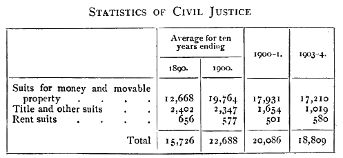
[S. 230] In 1903 there were 122 Subordinate Magistrates, 3 Sessions Judges, 8 District Magistrates, and the Chief Court. The Subordinate Judges of Chikmugalūr, Chitaldroog, and Hassan were also invested with the powers of Assistant Sessions Judges. In 1887 the system of trial by jury was introduced in Sessions cases. For appellate jurisdiction in criminal cases, the benches of the Chief Court that sit for civil appellate work dispose also of criminal appeals. The Chief Court moreover acts as a court of reference and a court of revision.
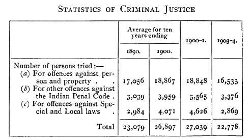
The Excise Commissioner is also Inspector-General of Registration. The number of sub-registry offices in 1904 was So, of which 59 were special, or with paid establishments, the remainder being in charge of tāluk revenue officers. The number of documents registered from 1881 to 1890 averaged 21,747; from 1891 to 1900, 46,251; and in 1904 the number was 57,637.
In addition to the local
audits, the State accounts have been examined at various times by auditors
deputed by the Government
Finance The revenue under all heads has risen. The increase under land is due to
extension of cultivation. Since 1885 mining leases and the royalty on
gold-production have added a new item to the revenue. The increase under excise
is due mainly to an improved system of control, but also to a larger consumption
arising from higher wages and the influx to the Gold Fields, and from the
employment on railways, public works, and coffee plantations of classes with
drinking habits. The decrease under land customs and assessed taxes is due to
these duties having been transferred to municipalities wherever they exist. The
only customs retained by the State are on areca-nuts, the bulk of which are the
produce of Kadūr and Shimoga Districts. An increase under forests took place
owing to a revival of the market for sandal-wood, and to a greater supply of
sleepers for railways. Subsequently the war between China and Japan temporarily
crippled one of the principal sandal-wood [S. 231] markets, and not only did the demand
for railway sleepers cease with the completion of the lines, but coal
began to be substituted for wood as fuel for the engines. Since 1902 a
substantial return has been received from the Cauvery Power installation
for supplying electricity to the gold-mines.
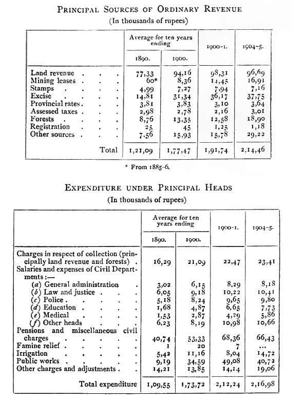
The land tenures in the State are sarkār or State, and inām. The former are held under ryotwāri or individual tenure, on payment [S. 232] of kandāyam or a fixed money assessment, settled for thirty years. Kandāyam lands are held direct from the State on annual leases, but the assessment is not as a rule altered or raised during the period for which it is fixed. The ordinary rates of assessment apply to the whole extent of the ryot's holding, and not to the area actually cultivated, as he has rights to a certain extent over included waste. Remission of assessment is not given in individual cases ; but when there is general loss of crop in a locality and consequent distress, remission may be granted as a measure of relief.
In the case of private estates, such as inām and kāyamgutta villages, and large farms of Government lands cultivated by payakaris or under-tenants, the land is held on the following tenures :
vāram, or equal division of produce between landlord and tenant, the former paying the assessment on the land to the State ;
mukkuppe, under which two-thirds of the produce goes to the cultivator, and one-third to the landlord, who pays the assessment ;
arakandāya or chaturbhāga, under which the landlord gets one-fourth and the cultivator three-fourths of the produce, each paying half the assessment ;
wolakandāya, in which the tenant pays a fixed money-rate to the landlord, which may either be equal to or more than the assessment.
An hereditary right of occupation is attached to all kandāyam lands. As long as the ryot pays the State dues he has no fear of displacement, and virtually possesses an absolute tenant-right as distinct from that of proprietorship. When the State finds it necessary to resume the land for public purposes, he always receives compensation, fixed either by mutual agreement or under the Land Acquisition Act. No legislation has been passed to check the acquisition of land by non-agricultural classes.
In the Malnād or hill country towards the Western Ghāts the holdings of the ryots are called vargs. A varg consists of all the fields held by one vargdār or farmer1 ; and these are seldom located together, but are generally found scattered in different villages, and sometimes in different tāluks. Attached to each varg are tracts of land called hankalu and hādya, for which no separate assessment is paid. Hankalu lands are set apart for grazing purposes, but have sometimes been used for 'dry' cultivation. Those attached to 'wet' fields are called tattina hankalu. Hādya are lands covered with low brushwood and small trees, which supply firewood or leaves for manuring the fields of the varg. Tracts of forest preserved for the sake of the wild pepper vines, bagni-palms, and certain gum-trees that grow in them, are called kāns, for which a cess is paid. [S. 233]
1 These terms often appear as warg and wargdār in official papers.
Lands for coffee cultivation have been granted from State jungles, chiefly in the Western Ghāts region. The plot applied for was sold by public auction. If the jungle was to be cleared, notice was given, to allow of officials removing or disposing of 'reserved' trees. Besides coffee nothing may be grown on the land, except shade trees for the coffee. Within five years a minimum of 500 coffee-trees to the acre must be planted. On the coffee-trees coming into bearing an excise duty, called hālat, of 4 annas per maund, was formerly levied on the produce, in lieu of land rent. But from 1885 an acreage assessment was substituted—either R. 1 per acre, with a guarantee for thirty years on the terms of the survey settlement, or a permanent assessment of Rs. 1½ per acre, on the terms of the Madras Coffee Land rules. Nearly all the large planters have adopted the latter conditions. But the great fall in the prices of coffee in recent years, owing to the competition of Brazil, has reduced this previously flourishing industry to a very depressed condition.
Lands have been offered since 1904 for rubber cultivation, in plots of 50 acres, selected with the consent of the Forest department, to be held free of assessment for the first five years, and subject to the assessment fixed by the survey settlement in the sixth year and after. The work of planting must be commenced within one year from the date of the grant ; and in stocking the area with rubber plants, trees may not be felled without permission.
Lands for cardamom cultivation are granted from the jungles on the eastern slopes of the Western Ghāts, where the plant grows wild. Tracts of not less than 5 or more than 200 acres, when applied for, are put up to auction, and may be secured on a twenty years' lease on terms similar to those for coffee lands. Not less than 500 cardamom plants per acre must be planted within five years, and nothing else may be cultivated on the ground. Trees, except of the 'reserved' kinds, may be felled to promote the growth of the cardamoms.
The tenure called kāyamgutta literally means a 'permanent village settlement' It owes its origin probably to depopulated villages being rented out by the State on a fixed but very moderate lease, on the understanding that the renter would restore them to a prosperous condition. But in the early part of last century even flourishing villages were granted to court favourites on this tenure, and some of the most valuable lands are thus held. Shrāya lands are waste or jungle tracts granted at a progressive rent, in order to bring them under cultivation. They are free of assessment for the first year, and the demand increases afterwards yearly from one-quarter to full rates in the fourth or fifth year. For the planting of timber, fruit, and fuel trees, unassessed waste land, or assessed 'dry' land, if unoccupied for ten years consecutively, [S. 234] is granted free of assessment for eight years, then rising by a quarter rate to full assessment in the twelfth year.
The conditions on which inām tenures are held vary considerably. Some are free of all demands, while in others the usual assessment is reduced. The grants differ also in origin, according as they were made to Brāhmans, for religious and charitable purposes, to village servants, for the maintenance or construction of tanks and wells, or otherwise.
Licences for exploring for minerals, on areas approved by Government, are granted on deposit of a fee of Rs. 10, to run for one year. No private or occupied lands may be explored without the consent of the owner, occupier, or possessor. Prospecting licences for minerals may be obtained for one year, on a minimum deposit of Rs. 100, and a rent of Rs. 50 per square mile or portion of a square mile. The licensee may select, within the year, a block for mining, not exceeding one square mile, in the licensed area.
Mining leases limited to one square mile, of rectangular shape, are granted for thirty years, on deposit of Rs. 1,000 as security, and furnishing satisfactory evidence that a sum of £10,000 will be raised within two years for carrying on mining operations on the block of land applied for. The cost of survey and demarcation is paid by the applicant, and mining operations must start within one year. An annual rent of R. 1 per acre is payable to the State on the mining block, together with all local cesses and taxes ; and in each year in which a net profit is made, a royalty of 5 per cent. is levied on the gross value of gold and silver produced. If the net profits exceed £25,000, an additional royalty is payable of 5 per cent. on the net profits above that sum. But in the case of a registered company, the royalty may be paid on divisible instead of net profits.
The land revenue assessment is fixed by the Revenue Survey department on the method already described (p. 214, above). The system resembles that followed in Bombay, which was preferred to that of Madras. The former was chosen because all the steps in survey, classification, and settlement are under the direction of one responsible head, and made to fit into one another.
The present revenue survey was introduced in 1863, and the settlement was completed in 1901. The settlements made under it are current for thirty years. The previous survey, made at the beginning of the nineteenth century, was necessarily very imperfect; and after the lapse of fifty years the records had become extremely defective, advantage having been taken of the insurrection in 1830 to destroy the survey papers in many cases.
In 1700 the Mysore king Chikka Deva Rājā acknowledged one-sixth to be the lawful share of the crop to be paid to him, but added [S. 235] a number of vexatious petty taxes to enhance the amount indirectly. In Bednūr (Shimoga District) Sivappa Naik's shist, fixed in 1660, was one-third of the gross produce. This continued for thirty-nine years, after which various additions were made, chiefly to raise funds for buying off the enemy. After the overthrow of Tipū Sultān, during the eleven years of Pūrnaiya's administration (1800-10), the highest land revenue was equivalent to 94 lakhs in 1809, and the average was 83 lakhs. During the twenty-one years of the Rājā's administration which followed (1811-31), the highest was 90 lakhs, and the average 79 lakhs. In the first year of British administration (1831-2), the land revenue was set down as 48 lakhs, but included in this were 83 different cesses, besides 198 taxes unconnected with it. The general average assessment was usually one-third of the gross produce. In 1881-2 the total revenue was 107 lakhs, of which the land yielded 71 lakhs. In 1903-4 the total revenue had risen to 214 lakhs, and the land revenue to 98 lakhs.
The two principal sources of excise revenue are toddy and arrack. The former, drawn from the date-palm, and also from coco-nut, palmyra, and bagni palms, is the immemorial beverage of the agricultural classes, a mild and comparatively innocuous drink, its average alcoholic strength being 2½ per cent. Arrack, which is far stronger and more harmful, is chiefly consumed by industrial labourers, and has an average alcoholic strength of 39½ per cent. The consumption of toddy is fairly stationary, while that of arrack has a decided tendency to increase year by year. Formerly the right to sell toddy was farmed out by Districts, and was virtually a monopoly in the hands of a few contractors, between whom and the Darbār was a large class of middlemen. Want of proper control not only led to the supply of inferior liquor, but threatened the destruction of the date groves themselves. The new system broke up each tāluk into convenient farms, which supplied a certain number of shops from particular groves. The number of toddy shops remained the same, so that the increase of revenue was entirely due to the abolition of needless intermediaries. As regards arrack, the policy has been to enhance the duty gradually up to the highest point consistent with the prevention of illicit distillation or contraband importation. In addition to this, the main causes which have tended to increase the revenue have been—the abolition in 1884 of all outlying distilleries and the concentration of manufacture in one distillery near Bangalore under centralized control ; and further, the separation in 1892 of the business of manufacture from that of distribution, and the adoption of a system for the sale of the privilege of retail vend. These measures led to the manufacture being taken up by European firms with large capital and [S. 236] superior technical resources, thus reducing the cost. Supplies were conveyed under separate contract to bonded depots in the Districts. In 1897 the still-head duty was raised to Rs. 4-12, and the retail rate to Rs. 6-6, per gallon, for liquor 20° under proof. The sale of the right of vend, on the 'separate shop system' in the cities and Gold Fields, and on the 'vend rent system' in tāluks or circles of villages, has secured to the State what previously formed the profits of middlemen. In 1898 a tree tax was introduced, for better regulating the consumption of toddy and conserving the date groves, the rate being Rs. 1-1 per tree per annum for date-trees, and corresponding rates for other palms. In 1901 a tree rent of 4 annas per tree per annum was levied on trees tapped for toddy. In 1903-4 there were 12 toddy depots and 3,837 retail shops, 962 of these being for the sale of bagni toddy. The number of trees tapped was 422,855, and the quantity of toddy consumed was 9,809,640 gallons. Retail shops for the sale of arrack numbered 931. The issue of spirits from the distillery amounted to 43,482 gallons. The greatest consumption is, of course, in the cities and the Gold Fields. The other sources of excise revenue are country beer, foreign liquors, hemp drugs (gānja and mājum), and opium. In 1899 the proportion of alcohol in country beer was fixed so as not to exceed 8 per cent. by volume. A scale of licence fees for the sale of foreign liquors was also prescribed. Country-made foreign spirits of weaker strength were introduced in 1904 to meet the requirements of the people, who were found in their absence to have recourse to inferior foreign stuff. Gānja is grown by contractors under departmental supervision in specified localities. There were 237 retail shops in 1903-4 for the sale of gānja and mājum, and 15,594 seers were sold. Opium, previously imported from Mālwā, has since 1903 been obtained from the Madras storehouse. There were 126 shops in 1903-4 licensed to sell opium, and 1,438 seers were consumed.
Up to 1901 there were ten Local fund circles, one for each of the eight Districts, and for the French Rocks and the Kolār Gold Fields. Two years later a new system was introduced, and a District board has been constituted for each District (in addition to the Kolār Gold Fields Sanitary Board), besides a tāluk board for each tāluk or sub-tāluk. In 1904 these boards consisted of 1,188 members, of whom 372 were appointed ex officio, and 816 were non-ofificial. Tāluk boards (since 1905) consist of 15 members : namely, 5 official, 5 elected, and 5 appointed by the State. District boards consist of 25 members ; namely, one non-official elected for each tāluk of the District by the members of the tāluk board from their own body, and the rest ex officio or appointed by the State. The members hold [S. 237] office ordinarily for three years. Their chief functions embrace the construction and maintenance of roads and bridges, with assistance of the Public Works department if required, improving and conserving the water-supply, the provision and upkeep of travellers' bungalows and musāfirkhānas (native resthouses), dispensaries, sanitation of villages, &c. Funds are obtained by a cess of one anna in the rupee on land revenue, and on revenue from excise, sayer, and forests.
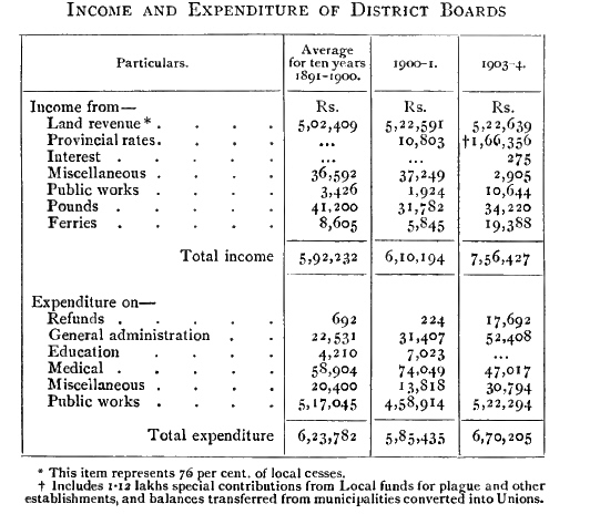
In 1901 the number of municipalities was 124 (exclusive of the Civil and Military Station of Bangalore), of which 117 had a population under 10,000, and 7 a population of from 10,000 to 100,000. In 1904, 36 of the minor municipalities, which were not tāluk headquarters and had a population of less than 3,000, were converted into Unions, a panchāyat being appointed for each Union. A panchāyat consists of 5 to 12 members, appointed by the State. The 88 municipalities in 1904 had 1,049 members, of whom 285 were officials. All of the members are natives, except about 20 Europeans.
The Kolār Gold Fields Sanitary Board was constituted in September, 1899, with 3 ex-officio members, and 4 non-official members nominated by the Mining Board. Its jurisdiction extends over the Kolār Gold Fields Sanitary Circle, embracing the Gold Fields and many of the surrounding villages. It deals with disposal of refuse, [S. 238] water-supply, prevention of overcrowding, drains and latrines, keeping and slaughter of live-stock, &c., burial and burning-grounds, prevention and treatment of infectious and contagious diseases, and underground sanitation of the mines.
The municipal board of the Civil and Military Station of Bangalore has consisted, since 1904, of a president, a medical officer, and 24 other members, 6 appointed by the Resident, and 18 elected, the former holding office for three years, and the latter for two. The Trades Association elect one member, Europeans and Eurasians 6, Muhammadans 3, and Hindus and others 8.
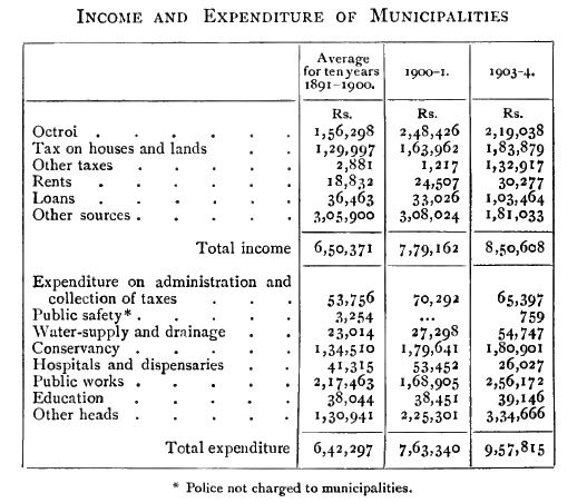
The Public Works department is controlled by a Chief Engineer, a Deputy-Chief Engineer, and two Superintending Engineers, who are in charge respectively of the Eastern and Western Circles. These are Royal Engineers or European officers. Separate branches have been formed for roads and buildings, and for irrigation. The executive staff are, with few exceptions, natives trained in Indian Engineering Colleges. Local works on a large scale, which require professional skill, arc carried out by the Public Works department on requisition from other departments, by which the needed funds arc placed at their disposal.
Of original works carried out by the department only a few can be mentioned. The railways include the line from Bangalore to Mysore [S. 239] and Nanjangūd south-westwards, to Gubbi westwards, to Hindupur northwards, and the Kolār Gold Fields and Birūr-Shimoga branches. The irrigation works include the Srīrāmadevar anicut and channels, and others in Mysore and Hassan Districts, the great Māri Kanave, Bora Kanave, Srīnivasa Sāgara, and many more. The excellent system of roads through the formerly impassable mountainous parts of Kadūr District, and the fine ghāt roads through passes to the west coast, deserve special mention. With these should be named the great bridges over the Tungabhadra at Harihar, over the Hemāvati at Sakleshpur, and the bridges at Belūr, Bāle Honnur, Tippur, Tadasa, and other places over broad rivers. Of hospitals, the most important are the Bowring and Lady Curzon in the Civil and Military Station of Bangalore, and the Victoria in the city. Other buildings include the public offices at Bangalore, the Palace, the Residency, the Central College, and Mayo Hall, the new Palace at Mysore city, with the public offices there, the Mahārājā's College, &c., and at Seringapatam the restoration of the Daryā Daulat.
Municipal and other water-supply schemes are represented by the Hesarghatta tank, the source of the Bangalore water-supply; the filling up of Pūrnaiya's Nullah at Mysore and the carrying out of the Kukarhalli and other water-works there ; the provision at Betmangala for the water-supply of the Kolār Gold Fields, and minor works of that nature in various towns. The transmission of electric power from the Cauvery Falls to the Kolār Gold Fields having been successfully accomplished, electric lighting from the same source has been introduced into Bangalore and is being carried out at Mysore. Large extensions have been laid out and occupied in Bangalore and Mysore city, with a new town at the Gold Fields, all on the most modern principles.
The total strength of the British and Native army stationed within Mysore on June 1, 1903, was as follows : British, 2,093 ; Native, 2,996 ; total, 5,089. The Mysore State forms for military purposes part of the Ninth (Secunderābād) Division, which is for the present directly under the Commander-in-Chief. It has a cavalry and an infantry brigade, as well as artillery. The only military station is Bangalore, which is also the head-quarters of a volunteer rifle corps. The total volunteer strength within Mysore, including detachments of railway volunteers, was 1,512 in 1903. The Coorg and Mysore Rifles also have detachments at Chikmugalūr and Sakleshpur, in the planting districts to the west.
The Mysore State force had a sanctioned strength of 2,722 in 1904, of whom nearly a half were Muhammadans and a fifth Marāthās, the rest being Hindus and Christians in about equal numbers. The force is composed of two regiments of Silladār cavalry, and three [S. 240] battalions of Barr infantry. In 1903 the former were 1,072 strong, and the latter 1,814. the Imperial Service Lancers, raised in April, 1892, form one cavalry regiment, stationed in Bangalore, and with them is kept up a transport corps of 300 ponies. The Local Service Cavalry regiment is stationed at Mysore. The Barr battalions have their head-quarters at Mysore city, Shimoga, and Bangalore, with detachments in out-stations. The State military expenditure was 7.9 lakhs in 1880-1, 6.1 lakhs in 1890-1, and 9.4 lakhs in 1903-4.
The police are under an Inspector-General. The sanctioned strength of the regular force in 1904 was 882 officers and 5,045 men, or one policeman to every 5-83 square miles and 1.073 inhabitants. The village police were for the first time provided with uniform and arms in 1901-2. They help the regular police in the prevention and detection of crime, and in reporting the arrival and departure of criminal gangs and suspicious-looking strangers. The system of night watch is regularly maintained in all the villages of the Maidān tracts. The watching by totis and talāris in ookkads and outposts on important roads and jungle tracts has worked well. There is a Police Training School, where recruits and officers and men are taught drill, codes, and surveying and drawing. But the police service is not as a rule popular with the educated classes of natives. Finger-prints and anthropometry have been used to trace criminals in recent years.
The special reserve is a body selected for good physique, and is better paid, equipped, and drilled than the other police. The members go through a course of musketry, and are held ready for emergencies in any part of the country, and are employed in putting down organized dacoities and serious disturbances of the public peace. There are three detachments, stationed respectively at Bangalore, Mysore city, and Shimoga.
The Kolār Gold Fields Police is a special body, with 50 officers and 279 men, under a separate European Superintendent, and is largely composed of Sikhs and Punjābis recruited from the north of India. It was formed in April, 1900, and has jurisdiction over the Bowringpet, Mālūr, and Mulbāgal tāluks.
The troops aid the police in various ways ; detachments of the Local Service Cavalry patrol certain roads, while the infantry act as treasury guards and escorts. The Railway police, reckoned as in British service, are under the Superintendent of Police of the Civil and Military Station of Bangalore, subject to the orders of the Resident.
The following are statistics of cognizable crime, the figures being the average for the five years ending 1901 : number of cases reported, 3,221 ; number decided in criminal courts, 1,828; number ending in acquittal or discharge, 584 ; number ending in conviction, 1,244. [S. 241]
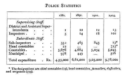
Convicts are employed on cleaning and grinding rāgi; on prison duties, as prison warders, servants, and gardeners; on the preparation of articles for use or consumption in the jails; on jail buildings, manufactures, and public works. The chief industries are printing, carpet, tent, and blanket-making, cloth-weaving, gunny and coir work, carpenter's and blacksmith's work in the Central jail at Bangalore; and weaving and spinning, basket and mat-making, and pottery in the Mysore District jail. The most numerous admissions into hospital on account of sickness are for malarial fevers. The high mortality in t8Si shown below was due to dysentery or diarrhoea, and anaemia; in 1901 there were four deaths from cholera.
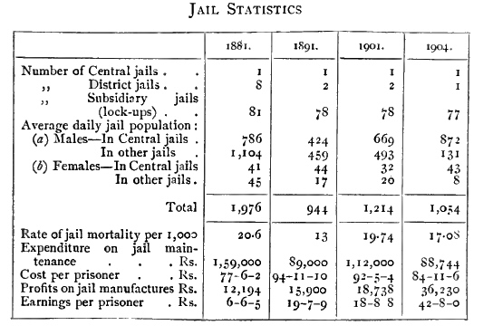
[S. 242] Highly as learning was always esteemed, education seems never under former native rulers to have been regarded as a duty of the State. It was left to the voluntary principle, and was mostly in the hands of the priests. At the same time we find that, in the primitive corporation of the 'village twelve,' a poet, who was also a schoolmaster, was sometimes provided instead of a goldsmith. Endowments were often given for promoting learning as a religious duty.
Education on modern lines was first introduced by European missionaries. In 1826 a Mysore Mission College was proposed for Bangalore by the London Mission, conducted by a staff of European professors, aided by learned pandits, and designed to attract students from all parts of India. But their home authorities were not prepared to carry it out. Between 1840 and 1854 the Wesleyans established schools at some of the District head-quarters with aid from Government, the principal being their institution at Bangalore, founded in 1851. At Mysore the Mahārājā maintained an English free school. The State expenditure on education in 1855 was Rs. 16,500 a year.
The Educational department was formed in 1857, and in 1858 a high school affiliated to the Madras University was established at Bangalore, converted in 1875 into the Central College. The Wesleyan schools in the Districts were taken over by Government, and vernacular schools gradually established in the tāluks. In 1861 a normal school, and in 1862 an engineering school, were attached to the high school at Bangalore. In 1868 the hobli school system, for extending primary education among the masses, was introduced, and greatly added to the operations of the department. The schools were to be supported by a local cess ; but in 1872 the proportion of 24 per cent. of Local funds was allotted as the village school fund, raised in 1903 to 33 per cent.
The famine of 1876-8 had a disastrous effect on all public undertakings. Education, which had greatly flourished, both public and private, was starved for want of funds. The normal schools were closed, the European Inspectors were dispensed with, the Director of Public Instruction was placed in charge of the Census and the Police in addition to Education, and later on of Archaeology instead of Police, all the cost of vernacular schools was thrown on Local funds, and rigid economy stood in the way of any expansion. In 1884 a revision was made of the higher institutions, but it was not till 1890 that a freer expenditure enabled progressive measures to be adopted. In 1887 the Mysore local examinations were instituted for teachers and pupils of vernacular schools, giving a definite aim to the courses of study. At the end of 1888 education in the Civil and Military Station of Bangalore was transferred to the Madras Educational department. In 1889 the cost of the tāluk vernacular schools was again made a charge on State [S. 243] funds, thus relieving the village school fund. In 1891 the number of native Deputy-Inspectors was doubled. The department is now controlled by an Inspector-General of Education, whose head-quarters were removed to Mysore in 1894 but again established at Bangalore in 1899. The State was divided in 1903 into two portions for control and inspection, between the Inspector-General and his Assistant. The former retains the eastern Districts, with head-quarters at Bangalore, and the latter has charge of the western Districts, with head-quarters at Mysore city. The only Europeans recruited from England are the heads of the colleges at Bangalore and Mysore. The inspecting staff was further strengthened in 1905.
Of the colleges affiliated to the Madras University, those of the first grade are the Central College at Bangalore and the Mahārāja's College at Mysore city. The former takes mathematics and physical science as the optional subjects for the B.A. degree, and the latter mathematics and history. The second-grade colleges are the St. Joseph's College at Bangalore, the Mahārānī's College at Mysore city, and the Sacred Heart College attached to the Convent of the Good Shepherd at Bangalore. This last and St. Joseph's are aided from the revenues of the Assigned Tract, and the others are supported by the State. The first-grade colleges are provided with hostels. There are also Sanskrit colleges of a high standard at Mysore, Bangalore, and Melukote, the two latter being aided. Bangalore has, moreover, been selected as the site of the Indian Institute of Research for post-graduate study, to be founded on Mr. Tata's endowment.
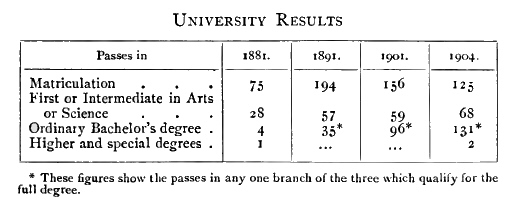
Secondary schools include high schools and middle schools. The former have the matriculation examination as their goal, while the latter prepare for the lower secondary examinations, the course being partly English and partly vernacular. In 1904 there were 202 State, 3 municipal, 55 aided, and 3 unaided schools, the last being middle schools. The amount of aid to private schools is based on their expenditure, and their efficiency as tested by the reports of Inspectors and results of public examinations. The proportion of the male population of school-going age under secondary instruction in 1904 was 2 per cent. [S. 244]
The primary stages are divided into upper and lower, the latter ending with the ability to read from printed books. In 1904 there were 1593 State, 285 aided, and 14 unaided primary schools. As to the qualifications of the teachers, out of 3,179 in State employ, 149 held a normal school or teacher's certificate, others had passed various examinations, including 154 who had passed the University matriculation or higher tests, leaving 1,002 who had not passed any. The minimum pay of the village schoolmasters was raised from Rs. 5 to Rs. 7 a month in 1901, but better prospects are needed for their future. With a view to providing funds for this purpose, the levy of fees has been introduced in all village schools, except in the lower primary classes, and the former rates of fees in other schools have been raised all round. For the benefit of children of artisans and agriculturists above 15, night schools have been opened, of which there are 67, with 1,500 pupils, most of them in the east, but some in all Districts. There are local committees for the control of all hobli and village schools.
The first girls' schools were established by European missionary ladies at Bangalore in 1840. Mission girls' schools were opened later in some of the large towns. In 1868 the Government began with one in Bangalore, and as years went on the number increased all over the country. The hobli schools established in 1868 received both boys and girls together. Owing to the early marriage system, which did not admit of girls staying beyond the age of ten, and the entire want of female teachers, the girls' schools were really infant schools. But the mission schools had an advantage in both respects, being able to keep their girls longer, and to provide native Christian women as teachers.
One of the steps that gave an impetus to public female education was the establishment at Mysore city of the Mahāram's Girls' School in 1881. This was confined to high-caste girls, and, with an unstinted expenditure, gave a free education. Its influential patronage overcame all objections, and it presented an acceptable compromise between Western methods and Eastern views as to the appropriate subjects of female education. It has for some years had Lady Superintendents from Girton or Newnham, and in 1902 was formed into a college, affiliated to the Madras University. Two Brāhman students took the B.A. degree in 1906. Admission is also now allowed of Christians and girls of low castes, provided they are of respectable family and approved by the management. By liberal scholarships girls have been induced to stay longer at school, and female teachers have been trained from among young widows, of whom there are at present ten adult and fourteen child-widows. The management is in the hands of a committee, and local committees have been appointed for girls' schools [S. 245] in other parts of the country. These are, however, reported to take little interest in the matter as a rule.
In 1881, 1891, and 1901 respectively there were 46, 113, and 230 girls' colleges and schools, the percentage of girls under instruction to the female population of school-going age being 0.81, 3.14, and 4.2 2. In 1904 there were 243 schools, and the proportion was 4 per cent. The State funds contributed 1¼ lakhs (of which Rs. 38,000 was for the Mahārānī's College), and Local and municipal funds Rs. 6,800, to female education in 1903-4. The high school classes learn English as a first language. In the highest class of the middle school English is begun as a second language. Zanāna teaching is carried on by ladies of the Church of England Zanāna Mission in Bangalore, Mysore city, and Channapatna, chiefly among Musalmān families.
There are State normal schools at Mysore city, Kolār, and Shimoga, for training teachers ; also a training department in the Mahārānī's College. State industrial schools are at work in Mysore and Hassan, mission industrial schools at Tumkūr and Kolār, with one for girls at Hassan, and a private industrial school at Melukote. The industrial school at Mysore has recently been reorganized1 and placed under an experienced Superintendent, who also inspects the other industrial schools in the State. An engineering school has been established at Mysore, for training subordinates for the Public Works department. Weaving schools have been opened at Hole-Narsipur, Dod-Ballāpur, Chiknāyakanhalli, and Molakālmura, with carpentry and drawing classes attached. There are altogether eighteen industrial schools, of which six are weaving schools. A school has been established at Channapatna for the revival of the decaying local industries of lacquer-work, and the preparation of steel wire for the strings of musical instruments. Commercial classes are conducted at Bangalore by certain officials, and receive aid from Government. Students are attached to the laboratories of the Agricultural Chemist, the State Geologist, and the State Bacteriologist, and also to the silk farm established by Mr. Tata, and to the workshops of the Southern Mahratta Railway. Those at the silk farm are village schoolmasters, of whom five are trained annually, and then appointed as inspectors of sericulture. State scholarships are given to students from Mysore learning electricity at New York, forestry at Oxford, and in the Teachers', Engineering, Medical, and Veterinary colleges of Madras or Bombay, in the Victoria Jubilee Institute and schools of Art at those places, and in the Forest School at Dehra Dun. One-fifth of the income from the Dāmodar Dās Charity Fund, yielding about Rs. 20,000 a year, has been assigned for scholarships to Gujarātī students selected by a committee—nine to those studying for the [S. 246] Bombay University examinations, one for a student of engineering or agriculture, and one for medicine. The remaining four-fifths are intended for post-graduate scholarships. One has been granted to a student for the history and economics tripos at Cambridge, and one to a student for the M.B. and C.M. course at Edinburgh, with a special view to practical microscope work. An institution of a special nature deserving of notice is the school for deaf-mutes and the blind at Mysore city, managed by a committee.
1 The Prince of Wales, on his recent visit to Mysore, laid the foundation stone of new buildings for it, to be called the Chāmarājendra Industrial Institute.
Most of the institutions for Europeans and Eurasians are in the Civil and Military Station of Bangalore, but the returns do not include regimental schools under the Army department. The number of pupils in the public schools was 1,314 in 1904. In the rest of the State there were 361, the majority being at the Urigam school on the Kolār Gold Fields. St. Joseph's College did well in the First Arts and matriculation. One European girl has passed the B.A. degree examination in English and French, and two the F.A. from the Sacred Heart and the Central College. The popular callings for young men are in the railway and telegraph departments, and the engineering and medical professions. Girls become nurses and governesses.
The number of Muhammadan pupils in all schools was 4,330 in 1881, 10,185 in 1891, 14,612 in 1901, and 13,383 (10,454 boys and 2,929 girls) in 1904. Six passed certain branches of the B.A. examination, one the First Arts, and one the matriculation. Only half-fees are levied from Muhammadan boys in all schools, and girls are free. There are also twenty-six scholarships allotted for Muhammadan students in the Central College, to encourage English education among them. Owing to the dearth of qualified teachers, the village Hindustānī schools are in a very poor condition. In 1904 there were 15 Muhammadans attending colleges, 3,581 in secondary schools, and 8,848 in primary schools. Some have received scholarships at the M.A.O. college at Aligarh.
An interesting effort has been made to introduce education among the Lambānis. In all, 12 schools have been opened for them—7 in Shimoga District, and the others in Tumkūr, Chitaldroog, and Hassan Districts. They were attended in 1904 by 235 boys and 10 girls. For the low castes or Panchamās there are 70 schools, with 1,910 pupils, of whom 277 are girls.
The proportion of the population of school-going age under instruction was 11 in 1881, 9 in 1891, 14 in 1901, and 13 in 1904. At the Census of 1901 the proportion of the population able to read and write was 5.06 per cent., being 9.27 per cent. for males, and 0.77 for females. The cities and the Gold Fields have the highest percentage ; and of the Districts, Kadūr stands highest and Mysore lowest. Shimoga, next to Kadūr, has the highest percentage of literate males, [S. 247] and Tumkūr of literate females. The scale of fees in State colleges and schools was raised in 1904 to the following monthly rates : Village schools, lower primary, free ; upper, 1 anna ; middle, 2 annas. Tāluk schools, lower primary, 2 annas ; upper, 3 annas ; middle, 4 annas. English middle schools, 8 annas, 12 annas, R. 1, Rs. 1-4, and Rs. 1-8, according to class. English high schools, Rs. 2 and Rs. 2-8 ; F.A. class, Rs. 4 ; B.A. class, Rs. 5.
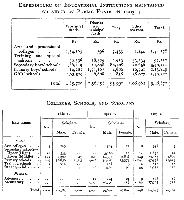
Among the oldest newspapers in the vernacular were the Kāsim-ul-Akhbār in Hindustānī, started in 1863, and still published; and the Karnātaka Prakāsika in Kanarese, begun in 1865 but discontinued at the end of 1898, the editor and proprietor having fallen an early victim to plague. [S. 248]
The number of newspapers and periodicals published in the State in 1901 was 11 in English, 7 in the vernaculars, and 3 in both English and vernacular. A third of the whole treat of politics. There are five English papers with a circulation of from 200 to 500, the principal being the Daily Post (Bangalore). All these give general news. Of the Kanarese papers, the Wesleyan Vrittānta Patrika (Mysore weekly) and Mahilāsakhi for women (Mysore monthly) have considerable circulations. Their Harvest Field (Mysore monthly) in English is also popular. The Nadegattnadi (Bangalore), Sūryodaya (Bangalore), Vrittānta Chintāmani (Mysore), are Kanarese weeklies, with circulations varying from 1,000 to 500, and give general and political news. In Hindustānī are the Kāsim-ul-Akhbār (bi-weekly), and the Edward Gazette, an old paper under a new name (weekly), both published in Bangalore, and treating of general and political news. The Tamil paper is the Tāraka (Bangalore bi-weekly), with a circulation of 200. Of the Kanarese monthly periodicals, Vidyādāyini is a journal of education. Karnātaka Granthamālā publishes new works, and Karnātaka Kāvyakalānidhi prints old unpublished works. All these are issued in Mysore city.
The number of books registered in 1901 was 30, exclusive of official publications, such as the volumes of inscriptions issued by the Archaeological department. There were 3 in English, 23 in Kanarese, 1 in Telugu, and 3 in Sanskrit and Kanarese. The subjects chiefly treated of come under the heads of religion, fiction, and history. The principal riginal works were four, of which two were based on the Rāmāyana story, one was an allegory on virtue and vice, and the other was a composition by a wife of the Mahārājā who died in 1868, on the reputed marriage of a Musalmān princess of Delhi to Cheluvarāya or Krishna, the god at Melukote, said to have taken place in the thirteenth century.
The Victoria (opened 1900) in Bangalore city, the Bowring in the Civil and Military Station, and the General Hospitals at Mysore and Shi moga, are first-class hospitals. Before the Victoria was opened, St. Martha's Hospital, founded by the Lady Superior of the Convent of the Good Shepherd, took the place of a civil hospital for Bangalore city. Second-class hospitals exist at the District head-quarters, and Local fund dispensaries at all tāluk head-quarters and large towns. A Medical School was established in 1882 for training subordinates, but was given up in 1886 in favour of paying students to attend the large and well-equipped Medical Colleges at Madras and Bombay. A local medical service was organized in 1884 and improved in 1897.
For women and children there are the Mahārānī's Hospital at Mysore, the Maternity at Bangalore, the Lady Curzon in connexion [S. 249] with the Bowring, and the Gosha Hospital of the Zanāna Mission. Native midwives are supplied to all the tāluks, who have been trained in the Lying-in Hospital at Madras, or in classes at the hospitals in Bangalore and Mysore city.
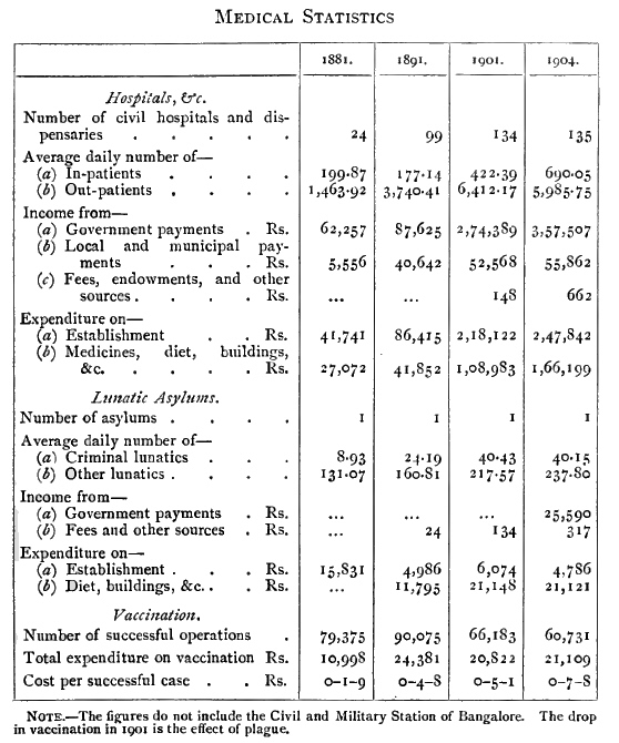
There is a Lunatic Asylum at Bangalore, in which at the end of 1903 there were 228 male and 86 female patients. During the year 24 were discharged as cured, and 11 as improved, while 23 died. The lunatics are employed in weaving cloth and kamblis, spinning, and gardening. In the Leper Asylum there were 11 male and 6 female lepers.
For vaccination there are 96 tāluk and 9 municipal vaccinators, besides the medical subordinates, and supervision is exercised by [S. 250] 9 inspectors. Vaccination is compulsory among State servants and school children1. Owing to the difficulties in the way of procuring good infant lymph for vaccination, a Vaccine Institute was established at Bangalore in 1892 for preparing lymph from the calf, in lanoline.
1 A Regulation passed in 1906 makes vaccination compulsory throughout 'notified areas.'
In 1896 an Eye Infirmary was established, and in 1899 a well-equipped Bacteriological Institute. Quinine was sold in 1904 in 3,426 packets, containing 102 powders of five grains each, at 418 post offices. The dose was raised in 1905 to seven grains, and it is proposed to sell through the village officials as well.
Sanitation has received special attention in the towns ; but in villages only the improvement and conservancy of the water-supply have been looked to, and the removal of manure pits from the immediate proximity of the dwellings insisted upon. The peremptory evacuation of villages on the occurrence of plague has inclined the people in some parts to build and permanently remain on the spots in their fields where they have been camped.
The topographical survey of the State was completed in 1886, The revenue survey was commenced in 1863 and the settlement brought to an end in 1901. The system followed is that of Bombay, as already explained (pp. 214, 234). The area surveyed includes the whole of the State, or 29,433 square miles. The maintenance of the survey records is also the duty of the Survey department.
[B. Lewis Rice : Mysore (revised edition, 1897).
Lewin B. Bowring : Haidar All and Tipū Sultān (Rulers of India series, 1893);
Eastern Experiences (1871).
Dr. Francis Buchanan : A Journey from Madras through the Countries of Mysore, Canara, and Malabar (1807 ; Madras reprint, 1870).
Major Mark Wilks : Historical Sketches of the South of India, in an Attempt to trace the History of Mysoor (3 vols., 1810-17 ; Madras reprint, 1869).]
District in the south of the State of Mysore, lying between 11° 36' and 13° 3' N. and 75° 55' and 77° 20' E., with an area of 5,496 square miles. It is bounded on the north by Hassan and Tumkūr Districts ; on the east by Bangalore and the Coimbatore District of Madras ; on the south by the Nīlgiri and Malabar Districts of Madras ; and on the west by Coorg.
The river Cauvery, besides forming the boundary for some distance both on the west and east, traverses the District from north-west to east, receiving as tributaries the Hemāvati, Lokapāvani, and Shimsha on the north, and the Lakshmantīrtha, Kabbani, and Honnu-hole or Suvarnāvati on the south. Lofty mountain ranges covered with vast forests, the home [S. 251] of the elephant, shut in the western, southern, and some parts of the eastern frontier. The only break in this mighty barrier is in the southeast, where the Cauvery takes its course towards the lowlands and hurls itself down the Cauvery Falls, called Gagana Chukki and Bhar Chukki, at the island of Sivasamudram. The principal range of hills within the District is the Biligiri-Rangan in the south-east, rising to 5,091 feet above the level of the sea. Next to these, the isolated hills of Gopālswāmi in the south (4,770 feet), and of Bettadpur in the north-west (4,389 feet), are the most prominent heights, with the Chāmundi hill (3,489 feet) to the south-east of Mysore city. The French Rocks (2,882 feet), north of Seringapatam, are conspicuous points of a line culminating in the sacred peak of Melukote (3,579 feet). Short ranges of low hills appear along the south, especially in the south-west. On the east are encountered the hills which separate the valleys of the Shimsha and Arkāvati, among which Kabbāldurga (3,507 feet) has gained an unenviable notoriety for unhealthiness.
Mysore District may be described as an undulating table-land, fertile and well watered by perennial rivers, whose waters, dammed by noble and ancient anicuts, enrich their banks by means of canals. Here and there granite rocks rise from the plain, which is otherwise unbroken and well wooded. The extreme south forms a tarai of dense and valuable but unhealthy forest, occupying the depression which runs along the foot of the Nīlgiri mountains. The lowest part of this is the remarkable long, steep, trench-like ravine, sometimes called the Mysore Ditch, which forms the boundary on this side, and in which flows the Moyār. The irrigated fields, supplied by the numerous channels drawn from the Cauvery and its tributaries, cover many parts with rich verdure. Within this District alone there are twenty-seven dams, the channels drawn from which have a total length of 807 miles, yielding a revenue of 5 1/3 lakhs.
The geological formation is principally of granite, gneiss, quartz, and hornblende. In many places these strata are overlaid with laterite. Stone for masonry, principally common granite, is abundant throughout the District. Black hornblende of inferior quality and potstone are also found. Quartz is plentiful, and is chiefly used for road-metalling. Dikes of felsites and porphyries occur abundantly in the neighbourhood of Seringapatam, and a few elsewhere. They vary from fine-grained hornstones to porphyries containing numerous phenocrysts of white to pink felspar, in a matrix which may be pale green, pink, red, brown, or almost black. The majority of the porphyries form handsome building stones, and some have been made use of in the new palace at Mysore. Corundum occurs in the Hunsūr tāluk. In Singaramāranhalli the corundum beds were found to be associated with an intrusion of olivine-bearing rocks, similar to those of the Chalk Hills near Salem, [S. 252] and large masses of a rock composed of a highly ferriferous enstatite, with magnetite and iron-alumina spinel or hercynite.
The trees in the extensive forest tract along the southern and western boundary are not only rich in species, but attain a large size. Of teak (Tectona grandis) there are several large plantations. Other trees include Shorea Talura, Pterocarpus Marsupium, Terminalia tomentosa, Lagerstroemia lanceolata, and Anogeissus latifolia, which are conspicuous and very abundant in the Muddamullai forest. In February most of these trees are bare of leaf, and represent the deciduous belt. In open glades skirting the forests and descending the Bhandipur ghāt are plants of a varied description. Bambusa arundinacea occurs in beautiful clumps at frequent intervals. There are also Helicteres Isora, Hibiscus Abelmoschus, and many others. Capparis grandiflora is most attractive in the Bhandipur forest, and there is also a species without thorns. Clusters of parasites, such as Viscum orientale, hang from many trees. On the Karabi-kanave range farther north the grasses Andropogon pertusus and Anthistiria ciliata attain an abnormal size, and are often difficult to penetrate. Ferns, mosses, and lichens are abundant in the rainy season. There are also a few orchids. The heaviest forest jungle is about Kākankote in the south-west. The Biligiri-Rangan range in the south-east possesses an interesting flora with special features. The growth includes sandalwood, satin-wood (Chloroxylon Swietenia), Polyalthia cerasoides, and others. The babūl (Acacia arabica) attracts attention by the road-side and in cultivated fields. Hedgerows of Euphorbia Tirucalli, Jatropha Curcas, and Vitex Negundo are not uncommon. In the poorest scrub tracts Phoenix farinifera is often gregarious. The growth in the parks at Mysore city is not so luxuriant as at Bangalore, where the soil is richer; but in the matter of species it is much the same. The flora of Chāmundi, which is a stony hill, is limited in species and poor in growth. Clinging to the rivers and canals are found such plants as Crinum zeylanica, Salix tetrasperma, and Pandanus odoratissimus.
The mean temperature and diurnal range at Mysore city in January are 73° and 25°; in May, 81° and 23°; in July, 75° and 16°; in November, 73° and 18°. The climate is generally healthy, but intermittent fevers prevail during the cold months. The annual rainfall averages 33 inches. The wettest month is October, with a fall of 8 inches ; then May, with 6 ; and next September, with 5 inches.
The earliest traditional knowledge we have relating to this District goes back to the time of the Maurya emperor, Chandra Gupta, in the fourth century B. C. At that time a State named Punnāta occupied the south-west. After the death of Bhadrabāhu at Sravana Belgola, the Jain emigrants whom he had led from Ujjain in the north, Chandra Gupta being his chief disciple, [S. 253] passed on to this tract. It is mentioned by Ptolemy, and its capital Kitthipura has been identified with Kittūr on the Kabbani, in the Heggadadevankote tāluk. The next mention concerns Asoka, who is said to have sent Buddhist missionaries in 245 B. C. to Vanavāsi on the north-west of the State, and to Mahisa-mandala, which undoubtedly means the Mysore country. After the rise of the Ganga power, their capital was established in the third century A. A. at Talakād on the Cauvery. They are said to have had an earlier capital, at Skandapura, supposed to be Gazalhatti, on the Moyār, near its junction with the Bhavāni ; but this is doubtful. In the fifth century the Ganga king married the Punnāta king's daughter, and Punnāta was soon after absorbed into the Ganga kingdom. In the eighth century the Rāshtrakūtas overcame and imprisoned the Ganga king, appointing their own viceroys over his territories. But he was eventually restored, and intermarriages took place between the two families. In the tenth century the Ganga king assisted the Rāshtrakūtas in their war with the Cholas. In 1004 the Cholas invaded Mysore under Rājendra Chola, and, capturing Talakād, brought the Ganga power to an end. They subdued all the country up to the Cauvery, from Coorg in the west to Seringapatam in the east, and gave to this District the name Mudikondacholamandalam.
Meanwhile the Hoysalas had risen to power in the Western Ghāts, and made Dorasamudra (Halebīd in Hassan District) their capital. About 1116 the Hoysala king, Vishnuvardhana, took Talakād and expelled the Cholas from all parts of Mysore. He had been converted from the Jain faith by the Vaishnava reformer Rāmānuja, and bestowed upon him the Ashtagrāma or 'eight townships,' with all the lands north and south of the Cauvery near Seringapatam. The Hoysalas remained the dominant power till the fourteenth century. The Muhammadans from the north then captured and destroyed Dorasamudra, and the king retired at first to Tondanūr (Tonnūr, north of Seringapatam). But in 1336 was established the Vijayanagar empire, which speedily became paramount throughout the South. One of the Sāluva family, from whom the short-lived second dynasty arose, is said to have built the great temple at Seringapatam. But Narasinga, the founder of the Narasinga or third dynasty, seized Seringapatam about 1495 by damming the Cauvery and crossing over it when in full flood. Later on, Ganga Rājā, the Ummattūr chief, rebelled at Sivasamudram and was put down by Krishna Rāya, in 1511. Eventually the Mysore country was administered for Vijayanagar by a viceroy called the Srī Ranga Rāyal, the seat of whose government was at Seringapatam. Among the feudal estates under his control in this part were Mysore, Kalale, and Ummattūr in the south, and the Changālva kingdom in the west. After the overthrow of Vijayanagar by the Muhammadans [S. 254] in 1565, the viceroy's authority declined, and the feudatories began to assume independence. At length in 1610 he retired, broken down in health, to die at Talakād, and Rājā Wodeyar of Mysore gained possession of Seringapatam. This now became the Mysore capital, and the lesser estates to the south were absorbed into the Mysore kingdom. Seringapatam was several times besieged by various enemies, but without success. From 1761 to 1799 the Mysore throne was held by the Muhammadan usurpers, Haidar Alī and Tipū Sultān. During this period several wars took place with the British, in the course of which Haidar Alī died and finally Tipū Sultān was killed. The Mysore family was then restored to power by the British, and Mysore again became the capital in place of Seringapatam. Owing to continuous misrule, resulting in a rebellion of the people, the Mysore Rājā was deposed in 1831 and the country administered by a British Commission. This continued till 1881, when Mysore was again entrusted, under suitable guarantees, to the ancient Hindu dynasty.
Of architectural monuments the principal one is the Somnāthpur temple, the best existing complete example of the Chālukyan style. It was built in 1269, under the Hoysalas. It is a triple temple, and Fergusson considered the sculpture to be more perfect than at Belūr and Halebīd. Other notable examples of the same style are the temples at Basarālu, built in 1235, and one at Kikkeri, built in 1171. The tall pillars of the temple in Agrahāra Bāchahalli are of interest. They are of the thirteenth century, and on the capital of each stands the figure of an elephant, with Garuda as the mahaut, and three or four people riding on it. As good examples of the Dravidian style may be mentioned the temples at Seringapatam, Nanjangūd, and on the Chāmundi hill. Of Muhammadan buildings the most noteworthy are the Gumbaz or mausoleum of Haidar and Tipū at Ganjam, and the Daryā Daulat summer palace at Seringapatam. Of the latter, Dr. Rees, who has travelled much in Persia and India, says :—
'The lavish decorations, which cover every inch of wall from first to last, from top to bottom, recall the palaces of Ispahān, and resemble nothing that I know in India.'
Attention may also be directed to the bridges of purely Hindu style and construction at Seringapatam and Sivasamudram. The numerous inscriptions of the District have been translated and published.
The population at each Census in the last thirty years was : (1871) 1,104,808, (1881) 1,032,658, (1891) 1,181,814, and (1901) 1,205,172. The decrease in 1881 was due to the famine of 1876-8. By religion, in 1901 there were 1,232,958 Hindus, 49,484 Musalmāns, 6,987 Animists, 3,707 Christians, 2,006 Jains, and 30 Parsīs. The density of population was 235 persons per square mile, that for the State being 185. The number of towns [S. 255] is 27, and of villages 3,212. Mysore, the chief town (population, 68,111), is the only place with more than 20,000 inhabitants.
The following table gives the principal statistics of population in 1901 :—
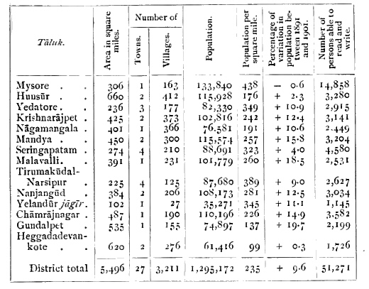
The Wokkaligas or cultivators are the strongest caste in numbers, their total being 320,000. Next come the outcaste Holeyas and Mādigas, of whom there are 194,000 and 25,000; the Lingāyats, numbering 173,000; Kurubas or shepherds, 127,000; Besta or fishermen, 10,200. The total of Brāhmans is 43,000. Among Musalmāns, the Sharīf's form nearly seven-tenths, being 29,000. The nomad Korama number 2,500; wild Kuruba, 2,300; and Iruliga, 1,600. About 74 per cent. of the total are engaged in agriculture and pasture; 8 per cent, each in unskilled labour not agricultural, and in the preparation and supply of material substances; 2.5 per cent. in the State service, and 2.4 per cent. in personal services; 1.9 per cent. in commerce, transport, and storage ; and 1.8 per cent. in professions.
The Christians in the District number 3,700, of whom 2,200 are in Mysore city. The total includes 3,300 natives. Early in the eighteenth century a Roman Catholic chapel was built at Heggadadevankote, but the priest was beaten to death by the people. A chapel at Seringapatam, which was courageously defended by the Christian troops, escaped the destruction of all Christian churches ordered by Tipū Sultān. After the downfall of the latter in 1799, the well-known Abbé Dubois took charge, and founded the mission at Mysore, where large churches, schools, and convents arc in existence. The London [S. 256] and Wesleyan Missions began work at Mysore in 1839, but the former retired in 1850. The Wesleyans have churches, a college, schools for boys and girls, and a printing press, and are building a large hospital for women and children.
Red soil prevails throughout the District, while one of the most valuable tracts of the more fertile black soil in the country runs through the south-east in the Chāmrājnagar tāluk and the Yelandūr jāgīr.
The following table gives statistics of cultivation in 1903-4 :—
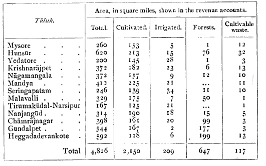
The crops, both 'wet' and
'dry,' are classed under two heads, according to the season in which they are
grown, hain and kār. The season for sowing both 'wet' and 'dry' hain crops opens
in July, that for sowing kār 'wet crops' in September, and for kār 'dry crops'
in April. It is only near a few rain-fed tanks in the east that both hain and
kār crops are now obtained from the same 'wet' lands in the year. On 'dry' lands
it is usual to grow two crops in the year, the second being a minor grain, if
the land is fertile enough to bear it. But of grains which form the staple food,
such as rāgi and jola, the land will only produce one crop as a rule, and
consequently the ryots arc obliged to choose between a hain or kār crop. In the
north the former is preferred, because the growth is there more influenced by
the monsoon. But in the south a kār crop is found more suitable, because the
springs and frequent rain afford a tolerable supply of water all the year round,
whereas the south-west monsoon, which falls with greater force on the forest
land, would render ploughing in June laborious. Rāgi in 1903-4 occupied 873
square miles; gram, 521 ; other food-grains, 360; rice, 184; oilseeds, 159;
garden produce, 27; sugar-cane, 10.
Coffee cultivation has been tried, the most successful being in the [S. 257] Biligiri-Rangan region. Much attention has
been paid to mulberry cultivation in the east, in connexion with
the rearing of silkworms. During the twelve years ending 1904 Rs.
29,000 was advanced as agricultural loans for land improvement, and
Rs. 16,500 for field embankments.
The area irrigated from canals is 122 square miles, from tanks and wells 72, and from other sources 15. The length of channels drawn from rivers is 807 miles, and the number of tanks 1,834, of which 157 are classed as 'major.'
The south and west are occupied by continuous heavy forest, described in the paragraph on Botany. The State forests in 1904 covered an area of 521 square miles, 'reserved' lands 81, and plantations 8. Teak, sandal-wood, and bamboos, with other kinds of timber, are the chief sources of forest revenue. The forest receipts in 1903-4 amounted to nearly 5 lakhs.
Gold-mining, experimentally begun at the Amble and Wolagere blocks near Nanjangūd, has been abandoned. Prospecting for gold has also been tried near Bannūr. Iron abounds in the rocky hills throughout the District, but is worked only in the Heggadadevankote and Malavalli tāluks. The iron of Malavalli is considered the best in the State. Stones containing magnetic iron are occasionally turned up by the ploughshare near Devanūr in the Nanjangūd tāluk. Talc is found in several places, and is used for putting a gloss on baubles employed in ceremonies. It occupies the rents and small veins in decomposing quartz, but its laminae are not large enough to serve for other purposes. Asbestos is found in abundance in the Chāmrājnagar tāluk. Nodules of flint called chakmukki are found in the east, and were formerly used for gun-flints.
Cotton cloth, blankets, brass utensils, earthenware, and jaggery (unrefined sugar) from both cane and date, are the principal manufactures. There is also some silk-weaving. The best cloth is made at Mysore and Ganjam. At Hunsūr factories were formerly maintained in connexion with the Commissariat, consisting of a blanket factory, a tannery and leather factory, and a wood-yard where carts and wagons were built. Although these have been abolished, their influence in local manufactures remains. Nearly all the country carts of the District are made here. There are also extensive coffee-works and saw-mills, under European management. The number of looms or small works reported for the District are: silk, 50; cotton, 4,267 ; wool, 2,400; other fibres, 862; wood, 200 ; iron, 360 ; oil-mills, 857 ; sugar and jaggery mills, 360.
A great demand exists for grain required on the west coast and in Coimbatore, and the Nīlgiri market derives a portion of its supplies from this District. There is also considerable trade with Bangalore [S. 258] and Madras. Many of the traders are Musalmāns, and on the Nīlgiri road Lambānis are largely employed in trade. The large merchants, who live chiefly in Mysore city, are for the most part of the Kunchigar caste. They employ agents throughout the District to buy up the grain, in many cases giving half the price in advance before the harvest is reaped. A few men with capital are thus able to some extent to regulate the market. Much of the trade of the country is carried on by means of weekly fairs, which are largely resorted to ; and at Chunchankatte in the Yedatore tāluk there is an annual fair which lasts for a month. Upon these the rural population are mainly dependent for supplies. The most valuable exports are grain, oilseeds, sugar, and jaggery ; and the most valuable imports are silk cloths, rice, salt, piece-goods, ghī, cotton and cotton thread, and areca-nuts.
The Mysore State Railway from Bangalore to Nanjangūd runs for 61 miles through the District from the north-east to the centre. The length of Provincial roads is 330 miles, and of District fund roads 539 miles.
The District is virtually secured against famine by the extensive system of irrigation canals drawn from the Cauvery and its tributaries. In 1900 some test works for relief were opened for a short time in the Mandya tāluk.
The District is divided into fourteen tāluks : Chāmrājnagar, Gundalpet, Heggadadevankote, Hunsūr, Krishnarājpet, Malavalli, Mandya, Mysore, Nāgamangala, Nanjangūd, Seringapatam, Tirumakūdal-Narsipur, Yedatore, and the Yelandūr jāgīf. It is under a Deputy-Commissioner, and subject to his control the tāluks have been formed into the following groups in charge of Assistant Commissioners : Mysore, Seringapatam, Mandya, and Malavalli, with head-quarters at French Rocks ; Nāgamangala and Krishnarājpet, with head-quarters at Krishnarājpet ; Chāmrājnagar, Nanjangūd, Gundalpet, and Tirumakūdal-Narsipur, with head-quarters at Nanjangūd ; Heggadadevankote, Hunsūr, and Yedatore, with head-quarters at Mysore city.
There are District and Subordinate Judge's courts at Mysore city, whose jurisdiction extends over Hassan District, besides two Munsifs' courts; in addition, there are Munsifs at Seringapatam and Nanjangūd. Dacoity is not infrequent.
The land revenue and total revenue are shown below, in thousands of rupees :—
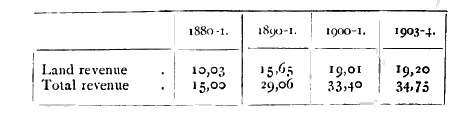
[S. 259] The revenue survey and settlement were introduced in the west in 1884, in the north and east between 1886 and 1890, in the south between 1891 and 1896. The incidence of land revenue per acre of cultivated area in 1903-4 was Rs. 1-4-6. The average assessment per acre on 'dry' land is R. 0-12-1 (maximum scale Rs. 2-4, minimum scale R. 0-1); on 'wet' land, Rs. 5-3-11 (maximum scale Rs. 11, minimum scale R. 0-4); on garden land, Rs. 3-15-6 (maximum scale Rs. 15, minimum scale Rs. 1-8).
In 1903-4, besides the Mysore city municipal board, there were seventeen municipalities—Hunsūr, Chāmrājnagar, Yedatore, Heggadadevankote, Gundalpet, Nanjangūd, Tirumakūdal-Narsipur, Piriyāpatna, Bannūr, Talakād, Seringapatam, Mandya, Krishnarājpet, Malavalli, Nāgamangala, Melukote, and French Rocks—with a total income of Rs. 47,000, and an expenditure of Rs. 42,000 ; and also 8 village Unions, converted in 1904 from previously existing minor municipalities —Sargūr, Sosale, Sāligrāma, Mirle, Kalale, Maddūr, Pālhalli, and Kikkeri—with a total income and expenditure of Rs. 10,000 and Rs. 18,000. Outside the municipal areas, local affairs are managed by the District and tāluk boards, which had an income of 1.5 lakhs in 1903-4 and spent 1.1 lakhs, including Rs. 86,000 on roads and buildings.
The police force in 1903-4 included 2 superior officers, 181 subordinate officers, and 1,210 constables. Of these, 46 officers and 275 constables formed the city police ; and 3 officers and 49 constables the special reserve. The Mysore District jail has accommodation for 447 prisoners. The daily average in 1904 was 200. In the 14 lock-ups the average daily number of prisoners was 17.
The percentage of literate persons in 1901 was 20.1 for the city and 3.1 for the District (7.3 males and 0.6 females). The number of schools increased from 675 with 22,346 pupils in 1890-1 to 778 with 23,126 pupils in 1900-1. In 1903-4 there were 766 schools (458 public and 308 private), with 22,853 pupils, of whom 3,379 were girls.
Besides the general hospital at Mysore city, there are 23 dispensaries in the District, at which 250,000 patients were treated in 1904, of whom 2,300 were in-patients, the number of beds available being 69 for men and 60 for women. The total expenditure was Rs. 82,000.
The number of persons vaccinated in 1904 was 13,896, or 11 per 1,000 of the population.
Central tāluk of Mysore District, Mysore State, lying between 12° 7' and 12° 27' N. and 76° 28' and 76° 50' E., with an area of 306 square miles. The population in 1901 was 133,840, compared with 134,684 in 1891, the decrease being chiefly due to plague. The tāluk contains Mysore City (population, 68,111), the head-quarters; and 163 villages. The land revenue demand in 1903-4 [S. 260] was Rs. 1,40,000. The north-west angle is bounded by the Cauvery and Lakshmantīrtha, but the main drainage flows south to the Kabbani. The country is undulating, and the principal height is the Chāmundi hill (3,489 feet). Channels from the Cauvery and Lakshmantīrtha irrigate some villages in the east and north-west. There are many tanks. The 'wet' lands have generally very good soil. The 'dry' lands vary, but are mostly shallow and stony. Coco-nut, areca-nut, betel-vines, plantains, and vegetables are largely grown round the city.
The dynastic capital of the Mysore State, and residence of the Mahārājā ; also head-quarters of the District and tāluk of the same name. It is situated in 12° 18' N. and 76? 40' E., at the north-west base of the Chāmundi hill, on the Mysore State Railway. The population fell from 74,048 in 1891 to 68,111 in 1901, the decrease being due to plague. The city covers an area of 7½ square miles, and is divided into seven muhallas : namely, the Fort, Lashkar, Devarāj, Krishnarāj, Mandi, Chāmarāj, and Nazarābād. The original city was built in a valley formed by two ridges running north and south. In recent years it has been completely transformed by extensions to the north and west, and by the erection of many fine public buildings ; but the old parts were very crowded and insanitary. A special Board of Trustees for improvements was formed in 1903, and Mysore promises to become a very handsome city in course of time. It is administered by a municipality, which in 1903-4 had an income of 2.2 lakhs, of which 1.2 lakhs was derived from taxes and Rs. 65,000 from octroi. The expenditure was 2.2 lakhs, including Rs. 39,000 on public works, Rs. 31,000 on conservancy, and Rs. 10,000 on education and charitable grants. Even in the past important sanitary measures have been carried out. In 1886 a complete system of drainage was provided for the fort, and the precincts of the palace were opened out and improved. One of the most beneficial undertakings was the filling in of the portentous great drain known as Pūrnaiya's Nullah, originally excavated in the time of that minister with the object of bringing the water of the sacred Cauvery into Mysore. It did not fulfil this purpose, and simply remained a very deep and large noisome sewer. Its place has now been taken by a fine wide road, called (after the Gaikwār of Baroda) the Sayājī Rao Road, flanked on either side by ranges of two-storeyed shops of picturesque design, called the Lansdowne Bazars. At the same time a pure water-supply was provided by the formation of the Kukarhalli reservoir towards the high ground on the west, from which water was laid on to all parts of the city in iron mains. This has since been supplemented by a high-level reservoir, the water in which is drawn from the Cauvery river near Anandūr, and forced up with the aid of turbines erected there. The new quarter, called (after the late Mahārājā) Chāmarājapura, more than [S. 261] doubled the area of the city. Conspicuous on the high ground to the west are the public offices, surmounted by a dome, standing in the wooded grounds of Gordon Park. Other prominent buildings in the vicinity are the Victoria Jubilee Institute, the Mahārājā's College, and the Law Courts. In 1897 the old palace in the fort was partially destroyed by fire ; and this has given occasion for the erection of a new palace on the same spot of more modern design, constructed of durable and less combustible materials. The opportunity has been taken to introduce some of the handsome porphyries and other ornamental stones found in Mysore, and stone-carvings on the lines of the famous ancient sculptured temples of the State are being used. Altogether, the new palace now approaching completion bids fair to be notable for its architecture and decorative features. The fort, which is the original nucleus of the city, is quadrangular, three of the sides being about 450 yards in length, and the remaining or south side somewhat longer. The palace in the interior was crowded round with houses, principally occupied by retainers. But open spaces have now been formed, and further improvements will follow the completion of the new building,
Mysore itself (properly Mahisūr, 'buffalo town') is no doubt a place of great antiquity, as it gave its name to the country as Mahisamandala in the time of Asoka in the third century B.C., and appears as Māhishmati in the Mahābhārata. Maisūrnād is mentioned in inscriptions of the eleventh and twelfth centuries. The original fort is said to have been built in 1524. But the modern city, even before the extensive rebuilding of recent years, could not boast of any great age. Though Mysore was the ancestral capital of the State, it was superseded by Seringapatam, which was the seat of the court from 1610 till the downfall of Tipū Sultān in 1799. The latter ruler had demolished the fort, and conveyed the stones to a neighbouring site called Nazarābād, where he intended to erect a new fort. On the restoration of the Hindu Rāj in 1799, the stones were taken back and the fort rebuilt. At the same time the recently destroyed palace was erected, and the court removed to Mysore. Thus few standing remains can claim to be older than about a hundred years. Interesting buildings are the house occupied by Colonel Wellesley (the future Duke of Wellington), and the Residency (now called Government House), erected in 1805 in the time of Sir John Malcolm by Major De Havilland. This has lately been much altered and extended.