mailto: payer@hdm-stuttgart.de
Zitierweise / cite as:
Mahanama <6. Jhdt n. Chr.>: Mahavamsa : die große Chronik Sri Lankas / übersetzt und erläutert von Alois Payer. -- 6. Kapitel 6: Vijaya's Ankunft -- Fassung vom 2006-05-27. -- URL: http://www.payer.de/mahavamsa/chronik06.htm. -- [Stichwort].
Erstmals publiziert: 2001-05-28
Überarbeitungen: 2006-05-27 [Ergänzungen]; 2006-05-25 [Ergänzungen]; 2006-05-14 [Ergänzungen]; 2006-05-01 [Ergänzungen]; 2006-04-21 [Umstellung auf Unicode!]; 2006-03-02 [Einfügen der Palitexts]; 2001-06-11 [Hinzufügung einer Abb.]
Anlass: Lehrveranstaltungen, Sommersemester 2001, 2006
©opyright: Dieser Text steht der Allgemeinheit zur Verfügung. Eine Verwertung in Publikationen, die über übliche Zitate hinausgeht, bedarf der ausdrücklichen Genehmigung der Übersetzers.
Dieser Text ist Teil der Abteilung Buddhismus von Tüpfli's Global Village Library
Pālitext: http://www.tipitaka.org/tipitaka/e0703n/e0703n-frm.html.-- Zugriff am 2001-06-06
Falls Sie die diakritischen Zeichen nicht dargestellt bekommen, installieren Sie eine Schrift mit Diakritika wie z.B. Tahoma.
Die Zahlreichen Zitate aus Malalasekera, G. P. <1899 - 1973>: Dictionary of Pāli proper names. -- Nachdruck der Ausgabe 1938. -- London : Pali Text Society, 1974. -- 2 vol. -- 1163, 1370 S. -- ISBN 0860132692. sind ein Tribut an dieses großartige Werk. Das Gesamtwerk ist online zugänglich unter: http://www.palikanon.com/english/pali_names/dic_idx.html. -- Zugriff am 2006-05-08.
Chaṭṭhapariccheda
Vijayāgamanaṃ
Alle Verse mit Ausnahme des Schlussverses sind im Versmaß vatta = siloka = Śloka abgefasst.
Das metrische Schema ist:
̽ ̽ ̽ ̽ ˘ˉˉˉ
̽ ̽ ̽ ̽ ˘ˉ˘ˉ
̽ ̽ ̽ ̽ ˘ˉˉˉ
̽ ̽ ̽ ̽ ˘ˉ˘ˉ
Ausführlich zu Vatta im Pāli siehe:
Warder, A. K. (Anthony Kennedy) <1924 - >: Pali metre : a contribution to the history of Indian literature. -- London : Luzac, 1967. -- XIII, 252 S. -- S. 172 - 201.
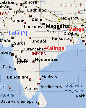
Abb.: Lage von Vaṅga, Kaliṅga und Magadha (©MS Encarta)
1 Vaṅgesu Vaṅganagare
Vaṅgarājā ahū pure;
Kāliṅgarañño dhitā 'si
mahesī tassa rājino.
1. Einstmal lebte im Vaṅgaland1, in der Vaṅgahauptstadt ein Vaṅgakönig. Die Königin dieses Königs war die Tochter des Kaliṅgakönigs2.
Kommentar:
1 Vaṅgaland = heutiges Bengalen (বঙ্গ, বাংলা, বঙ্গদেশ, বাংলাদেশ)
"Vaṅga, Vaṅgā The name of a people and their country, the modern Bengal.
It is nowhere mentioned in the four Nikāyas, nor included among the Mahājanapadas.
The mother of Sīhabāhu and Sīhasīvalī was a Vaṅga princess, the daughter of the Vanga king who had married the daughter of the king of Kaliṅga (Mhv.vi.1ff.; Dpv.ix.2).
The Milinda (p. 359) mentions Vaṅga as a trading place to be reached by sea."
[Quelle: Malalasekera, G. P. <1899 - 1973>: Dictionary of Pāli proper names. -- Nachdruck der Ausgabe 1938. -- London : Pali Text Society, 1974. -- 2 vol. -- 1163, 1370 S. -- ISBN 0860132692. -- s. v.]
"Bengal, known as Bôngo (Bengali: বঙ্গ), Bangla (বাংলা), Bôngodesh (বঙ্গদেশ), or Bangladesh (বাংলাদেশ) in Bangla, is a region in the northeast of South Asia. Today it is mainly divided between the independent nation of Bangladesh [গণপ্রজাতন্ত্রী বাংলাদেশ] (eastern Bengal), and the Indian federal republic's constitutive state of West Bengal [পশ্চিম বঙ], although some regions of the previous kingdom of Bengal (during local monarchial regimes and British rule) are now part of the neighbouring Indian states of Bihar [बिहार], Tripura [ত্রিপুরা] and Orissa [ଓଡ଼ିଶା]." [Quelle: http://en.wikipedia.org/wiki/Bengal. -- Zugriff am 2006-05-13]
"Bengal had been quite distant and cut off (by the rivers, especially the Ganga [गंगा] and the Brahmaputra [ব্ৰহ্মপুত্ৰ]) from the mainland of India for ages. The history of Bengal has not always followed that of the rulers of central parts of India. Ancient history
From the 6th century BC, most of Bengal was apart of the powerful kingdom of Magadha, which was an ancient Indo-Aryan kingdom of ancient India, mentioned in both the Ramayana and the Mahabharata. It was also one of the four main kingdoms of India at the time of Buddha, having risen to power during the reigns of Bimbisara (c. 544-491 BCE) and his son Ajatashatru (c. 491-460 BCE). Magadha spanned to include most of Bihar and much of Bengal.Magadha formed one of the sixteen Mahā Janapadas (Sanskrit, "great country"). The Magadha empire included republican communities such as Rajakumara. Villages had their own assemblies under their local chiefs called Gramakas. Their administrations were divided into executive, judicial, and military functions. Bimbisara was friendly to both Jainism and Buddhism and suspended tolls at the river ferries for all ascetics after the Buddha was once stopped at the Ganges River for lack of money.
In 326 BCE, the army of Alexander the Great [Μέγας Αλέξανδρος] approached the boundaries of Magadha. The army, exhausted and frightened by the prospect of facing another giant Indian army at the Ganges River, mutinied at the Hyphasis (modern Beas [ਬਿਆਸ]) and refused to march further East. Alexander, after the meeting with his officer, Coenus [Koινoς], was convinced that it was better to return.Magadha was the seat of the Maurya Empire, founded by Chandragupta Maurya, which extended over nearly all of South Asia and parts of Persia and Afghanistan under Ashoka the Great; and, later, of the powerful Gupta Empire, which extended over the northern Indian subcontinent and parts of Persia and Afghanistan.
One of the earliest foreign references to Bengal is the mention of a land named Gangaridai by the Greeks around 100 BCE. The word is speculated to have come from Gangahṛd (Land with the Ganges in its heart) and believed to be referring to an area in Bengal.Early middle ages
The first recorded independent king of Bengal was Shashanka [শশাঙ্ক] - reigning from 606.
More concrete evidence of Bengal becoming an independent political entity is found in the 6th century, with the first recorded independent king of Bengal - Shashanka - reigning around 606.The first Buddhist Pala king of Bengal, Gopala I came to power in 750 in Gaur by election. This event is recognized as one of the first democratic elections in South Asia since the time of the Mahā Janapadas. The dynasty's most powerful kings, Dharampala (reigned 775-810) and Devapala (reigned 810-850) united Bengal and made the Pala family one of the most important dynasties in ninth-century India. Internecine strife during the reign of Narayanpala (reigned 854-908) and administrative excesses led to the decline of the dynasty.
A brief revival of the kingdom under Mahipala I (reigned 977-1027) ended in battle against the powerful, South Indian Chola [சோழர் குலம்]kingdom. The rise of the Chandra dynasty in southern Bengal expedited the decline of the Palas, and the last Pala king, Madanpala, died in 1161.The Malla dynasty emerged in Bengal in the seventh century, although they only rose to prominence in the 10th century under Jagat Malla who moved his capital to Vishnupur. Unlike the Buddhist Palas and Chandras, the Hindu Mallas worshipped first the Hindu god Shiva, then the Hindu god Vishnu. The Mallas built temples and spectacular religious monuments during their rule in Bengal.
Under the Sena dynasty, which lasted from 1095 to 1260, Bengali [বাংলা] emerged as a distinct and important language in northern India, and Hinduism began to displace older Buddhism.Muslim rule
The Turkic invasion of India (including Bengal) came in the early 13th century. The invaders defeated the Sena king Laxmansena at his capital, Nabadwip in 1203 (1204?) The Deva family — the last Hindu dynasty to rule in Bengal — ruled briefly in eastern Bengal, although they were suppressed by the mid-fourteenth century.During the early Muslim period, the former kingdom became known as the Sultanate of Bangala, ruled intermittently from the Sultanate of Delhi [دلی سلطنت]. The chaotic shifts in power between the Afghan and Turkish rulers of that sultanate came to an end when Moghul [دولتِ مغل] rule became established in Bengal during the sixteenth century.
In 1534, the Afghan Sher Shah Suri [شیر شاه سورى], or Farid Khan — a man of incredible military and political skill — succeeded in defeating the superior forces of the Mughals under Humayun [نصيرالدين همايون] at Chausa (1539) and Kannauj (1540). Sher Shah fought back and captured both Delhi [दिल्ली] and Agra [आगरा] as he established the most powerful Bengali kingdom that would ever exist, stretching far into Panjab [Gurmukhi: ਪੰਜਾਬ, Shahmukhi: پنجاب]. Sher Shah's administrative skill showed in his public works, including the Grand Trunk Road connecting Sonargaon [সোনারগাঁও] in Bengal with Peshawar [پیشاور] in the Hindu Kush [هندوکش]. Sher Shah's rule ended with his death in 1545, although even in those five years his reign would have a powerful influence on Indian society, politics, and economics.Shah Suri's successors lacked his administrative skill, and quarrelled over the domains of his empire. Humayun, who then ruled a rump Mughal state, saw an opportunity and in 1554 seized Lahore [لاہور] and Delhi. Humayun's death in 1556 led to the accession of Akbar [جلال الدین محمد اکب], the greatest of the Mughal emperors, who defeated the Karani rulers of Bengal in 1576 and ruled through governors. Akbar exercised progressive rule and oversaw a period of prosperity (through trade and development) in Bengal and northern India.
Bengal's trade and wealth so impressed the Moghuls that they called the region the "Paradise of the Nations". Administration by governors appointed by the court of the Mughal Empire court (1575-1717) gave way to four decades of semi-independence under the Nawabs [نواب] of Murshidabad, who respected the nominal sovereignty of the Mughals in Delhi. The Nawabs granted permission to the French East India Company to establish a trading post at Chandernagore in 1673, and the British East India Company at Calcutta [কলকাতা] in 1690.When the British East India Company began strengthening the defences at Fort William (Calcutta), the Nawab, Siraj Ud Daulah, at the encouragement of the French, attacked. Under the leadership of Robert Clive, British troops and their local allies captured Chandernagore in March 1757 and seriously defeated the Nawab on June 23 1757 at the Battle of Plassey [পলাশীর যুদ্ধ], when the Nawab's soldiers betrayed him. The Nawab was assassinated in Murshidabad, and the British installed their own Nawab for Bengal and extended their direct control in the south. Chandernagore was restored to the French in 1763. The Bengalis attempted to regain their territories in 1765 in alliance with the Mughal Emperor Shah Alam II, but were defeated again at the Battle of Buxar (1765).
The center of Indian culture and trade shifted from Delhi to Calcutta when the Mughal Empire fell.
Dutch coloniesOn 1608 the Dutch created their first Indian colony. In 1625 Vereenigte Oostindische Companie of Holland, more commonly known as the Jan Companie, established a settlement at Chinsurah a few miles south of Bandel to trade in opium, salt, muslin and spices. They built a fort called Fort Gustavius and a church and several other buildings. A famous Frenchman, General Perron who served as military advisor to the Mahrattas, settled in this Dutch colony and built a large house here. The Dutch settlement of Chinsurah survived until 1825 when the Dutch in their process of consolidating their interests in modern day Indonesia, ceded Chinsurah to the English in lieu of the island of Sumatra. Fort Gustavius has since been obliterated from the face of Chinsurah and the church collapsed recently due to disuse, but much of the Dutch heritage remains. These include old barracks, the Governor's residence, General Perron's house, now the Chinsurah College and the old Factory Building, now the office of the Divisional Commissioner.
British ruleDuring British rule, Bengal experienced two devastating famines costing millions of lives in 1770 and 1943. Scarcely five years into the British East India Company's rule, the catastrophic Bengal famine of 1770, one of the greatest famines of history occurred. Up to a third of the population died in 1770 and subsequent years.
- See also: Bengal Renaissance and Bengal Presidency
The Indian Mutiny of 1857 replaced rule by the Company with the direct control of Bengal by the British crown.
A centre of rice cultivation as well as fine cotton called muslin and the world's main source of jute fibre, Bengal, from the 1850s became one of India's principal centres of industry, concentrated in the capital Kolkata (known as Calcutta under the British, always called 'Kolkata' in the native tongue of Bengali) and its emerging cluster of suburbs. Most of the population nevertheless remained dependent on agriculture, and despite its leading role in Indian political and intellectual activity, the province included some very undeveloped districts, especially in the east. In 1877, when Victoria took the title of "Empress of India", the British declared Calcutta the capital of the British Raj.India's most populous province (and one of the most active provinces in freedom fighting), in 1905 Bengal was divided by the British rulers for administrative purposes into an overwhelmingly Hindu west (including present-day Bihar and Orissa) and a predominantly Muslim east (including Assam [অসম]) (1905 Partition of Bengal). Hindu - Muslim conflict became stronger through this partition. While Hindu Indians disagreed with the partition saying it was a way of dividing a Bengal which is united by language and history, Muslims supported it by saying it was a big step forward for Muslim society where Muslims will be majority and they can freely practice their religion as well as their culture. But owing to strong Hindu agitation, the British reunited east and west Bengal in 1912, and made Bihar and Orissa a separate province.
Another major famine occurred during the second world war, the Bengal famine of 1943, in which an estimated 3 million people died.Bengal Renaissance
The Bengal Renaissance took place throughout the nineteenth century. During this period, Bengal witnessed an intellectual awakening that is similar to Renaissance in Italy. Under the impact of British rule the Indian intellect learned to raise questions about life and beliefs. It led to the creation of great literary works and questioning of established socio-religious orthodoxy.This is a very significant portion of the History of Bengal. The major players leading this included:
Raja Rammohun Roy [রাজা রামমোহন রায়] (1774-1833)
Institutions such as the Asiatic Society (est.1784), Fort William College (1800), Serampore College (1817), Hindu College (1817) (later rechristened Presidency College), General Assembly's Institution (now known as Scottish Church College)(1830), Calcutta School-book Society (1817), Calcutta Medical College (1835), University of Calcutta (1857), and Bethune College (1879) contributed significantly to the Renaissance.Henry Louis Vivian Derozio (1809-31) and his radical disciples called Young Bengal
Debendranath Tagore [দেবেন্দ্রনাথ ঠাকুর] (1817-1905) and his followers,Akshay Kumar Datta (1820-86)
- Ishwar Chandra Vidyasagar [ঈশ্বর চন্দ্র বিদ্যাসাগর] (1820-91)
Michael Madhusudan Dutt [মাইকেল মধুসূদন দত্ত] (1824-73)- Bankimchandra Chattopadhyay (1838-94)
- Swami Vivekananda [স্বামী বিবেকানন্দ](1863-1902)
Partitions of Bengal
In the 20th century, the partitions of Bengal, occurring twice, has left indelible marks on the history and psyche of the people of Bengal. The first partition occurred in 1905 and the second partition was in 1947.
- Main article: Partition of Bengal
As partition of British India into Hindu and Muslim dominions approached in 1947, Bengal again split into the state of West Bengal of secular India and a Muslim region of East Bengal under Pakistan, renamed East Pakistan in 1958. East Pakistan (East Bengal) later rebelled against Pakistani military rule to become independent republic of Bangladesh, literally "Land of Bengal", after a war of independence against the Pakistani army in 1971. West Bengal remains a part of India. However, culturally and sociologically, the two segments of Bengal share considerably more than just a single language.
Bengal (both West Bengal and Bangladesh) is now one of the most densely populated regions of the world."
[Quelle: http://en.wikipedia.org/wiki/History_of_Bengal. -- Zugriff am 2006-05-13]
2 Kaliṅga = heutiges Orissa
"Kāliṅga. A country: the Kālingarattha. It is one of the seven political divisions mentioned in the time of the mythical king Renu and is given first in the list, its capital being Dantapura and its king Sattabhū. (D.ii.235f; see also Mtu.iii.208; the Mtu. also mentions a king Uggata of Dantapura, iii.364f).
It is not, however, included in the list of sixteen Janapadas appearing in the Anguttara Nikāya (A.i.213, etc.), but is found in the extended list of the Niddesa (CNid.ii.37). A later tradition (Bu.xviii.6) states that after the Buddha's death, a Tooth was taken from among his relics and placed at Kālinga, where it was worshipped. From Kālinga the Tooth was brought to Ceylon, in the time of King Sirimeghavanna, by Hemamālā, daughter of Guhasīva, king of Kālinga, and her husband Dantakumāra, a prince of the Ujjeni royal family. In Ceylon the Tooth became the "Palladium" of the Sinhalese kings. (Cv.xxxvii.92; see also Cv.Trs.i.7, n.4; the Dāthādhātuvamsa gives details, J.P.T.S.1884, pp.108ff).
The Jātakas contain various references to Kālinga. There was once a great drought in Dantapura, and the king, acting on the advice of his ministers, sent brahmins to the king of Kuru to beg the loan of his state elephant, Añjanavasabha, credited with the power of producing rain. On this occasion, however, the elephant failed and the Kālinga king, hearing of the virtues practised by the king and people of Dantapura, offered them himself, upon which rain fell. See the Kurudhamma Jātaka, J.ii.367ff, also DhA.iv.88f. A similar story is related in the Vessantara Jātaka, vi.487, where the Kālinga brahmins ask for and obtain Vessantara's white elephant that he may stay the drought in Kālinga.
Another king of Kālinga was a contemporary of Aruna, the Assaka king of Potali. The Kālinga king, in his eagerness for a fight, picked a quarrel with Aruna, but was worsted in battle, and had to surrender his four daughters with their dowries to Aruna (J.iii.3f).
The Kālingabodhi Jātaka relates the story of another ruler of Kālinga while, according to the Sarabhanga Jātaka, a certain king of Kālinga (J.v.135f) went with two other kings, Atthaka and Bhīmaratta, to ask Sarabhanga questions referring to the fate of Dandakī. There they heard the sage preach, and all three kings became ascetics. Another king of Kālinga was Nālikīra, who, having ill-treated a holy man, was swallowed up in the Sunakha-niraya, while his country was laid waste by the gods and turned into a wilderness (Kālingārañña). The Kālinga-arañña is referred to in the Upāli Sutta (M.i.378); the story is related in J.v.144 and, in greater detail, in MA.ii.602ff. In the Kumbhakāra Jātaka (J.iii.376) the Kālinga king's name is Karandu.
From early times there seems to have been political intercourse between the peoples of Kālinga and Vanga; Susīmā, grandmother of Vijaya, founder of the Sinhalese race, was a Kālinga princess, married to the king of Vanga (Mhv.vi.1; Dpv.ix.2ff). Friendly relations between Ceylon and Kālinga were evidently of long standing, for we find in the reign of Aggabodhi II. (601-11 A.C.) the king of Kālinga, together with his queen and his minister, coming over to Ceylon intent on leading the life of a recluse and joining the Order under Jotipāla. Aggabodhi and his queen treated them with great honour (Cv.xlii.44ff). Later, the queen consort of Mahinda IV. came from Kālinga and Vijayabāhu I. married a Kālinga princess, Tilokasundarī (Cv.lix.30). We are told that scions of the Kālinga dynasty had many times attained to the sovereignty of Ceylon and that there were many ties of relationship between the royal families of the two countries (Cv.lxiii.7, 12f). But it was Māgha, an offspring of the Kālinga kings, who did incomparable damage to Ceylon and to its religion and literature (Cv.lxxx.58ff).
According to the inscriptions, Asoka, in the thirteenth year of his reign, conquered Kālinga and this was the turning-point in his career, causing him to abhor war (Mookerji: Asoka, pp.16, 37, 214). Among the retinue sent by him to accompany the branch of the Sacred Bodhi Tree on its journey to Ceylon, were eight families of Kālinga (Sp.i.96).
Asoka's brother Tissa, later known as Ekavihāriya, spent his retirement in the Kālinga country with his instructor Dhammarakkhita, and there Asoka built for him the Bhojakagiri-vihāra (ThagA.i.506).
According to the Vessantara Jātaka (J.vi.521), the brahmin village Dunnivittha, residence of Jūjaka, was in Kālinga.
Kālinga is generally identified with the modern Orissa. (CAGI.590ff; Law: Early Geography, 64; see also Bhandarkar: Anct. Hist. of Deccan, p.12)."
[Quelle: Malalasekera, G. P. <1899 - 1973>: Dictionary of Pāli proper names. -- Nachdruck der Ausgabe 1938. -- London : Pali Text Society, 1974. -- 2 vol. -- 1163, 1370 S. -- ISBN 0860132692. -- s. v.]
"Kaliṅga was an ancient kingdom of central-eastern India, in the province of Orissa. Kalinga was a rich and fertile land that extended from the river Subarnarekha to Godavari and from Bay of Bengal to Amarkantak range in the West. The kingdom had a formidable maritime empire with trading routes linking Sri Lanka, Burma, Thailand, Vietnam, Borneo, Bali, Sumatra and Java. Colonists from Kalinga settled in far away places such as Sri Lanka, Burma as well as the Indonesia archipelago. Even today Indians are referred to as Klings in Malaysia because of this. Many Sri lankan kings both Sinhalese and Tamil claimed decent from Kalinga dynasties.
Kalinga is mentioned in the Adiparva, Bhismaparva, Sabhaparva, Banaprava of Mahabharat so also is the conquest of Karna. Kalinga King Srutayu stated to have fought the Mahabharat war for the Kauravas. Kalinga is also mentioned as Calingae in Megasthenes' book on India - Indica:
- "The Prinas and the Cainas (a tributary of the Ganges) are both navigable rivers. The tribes which dwell by the Ganges are the Calingae, nearest the sea, and higher up the Mandei, also the Malli, among whom is Mount Mallus, the boundary of all that region being the Ganges." (Megasthenes fragm. XX.B. in Pliny. Hist. Nat. V1. 21.9-22. 1.)
- "The royal city of the Calingae is called Parthalis. Over their king 60,000 foot-soldiers, 1,000 horsemen, 700 elephants keep watch and ward in "procinct of war." (Megasthenes fragm. LVI. in Plin. Hist. Nat. VI. 21. 8-23. 11.)
The Kalinga script, derived from Brahmi, was used for writing. Among the offshoots, Kalinga script had the maximum resemblance with the parent script, Brahmi and later modified to Oriya script in the beginning of the second millennium. This makes the Oriya Script as the most unique and least distorted script among the Indic scripts. )
This region was scene of the bloody war fought by the Mauryan king Asoka the Great of Magadha around 260 BCE, and whose death and destruction later served as a precursor as one of the main centers of Buddhism.
Kharavela was a famous king of Kalinga during the 2nd century BCE, who, according to the Hathigumpha inscription, attacked Rajagriha in Magadha, thus inducing the Indo-Greek king Demetrius to retreat to Mathura."
[Quelle: http://en.wikipedia.org/wiki/Kalinga_%28India%29. -- Zugriff am 2006-04-30]
"Orissa [ଓଡ଼ିଶା] (2001 provisional pop. 36,706,920), 60,162 sq mi (155,820 sq km) is a state situated in the east coast of India. Orissa is bounded on the north by Jharkhand [झारखंड], on the north-east by West Bengal [পশ্চিম বঙ্গ], on the east by the Bay of Bengal, on the south by Andhra Pradesh [ఆంధ్ర ప్రదేశ్] and on the west by Chhattisgarh [छत्तीसगढ़].
The relatively unindented coastline (c.200 mi/320 km long) lacks good ports except for the deepwater facility at Paradip. The narrow, level coastal strip, including the Mahanadi River delta, is exceedingly fertile. Rainfall is heavy and regular, and two crops of rice (by far the most important food) are grown annually. The state is known for its temples, especially in the cities of Konark [कोनार्क], Puri, and Bhubaneswar [ଭୁବନେଶ୍ବର].Orissa has several popular tourist destinations. Puri, with the Jagannatha's temple on the sea, and Konark, with the Sun Temple, are visited by thousands of westerners every year. Along with the Lingaraja Temple of Bhubaneswar, the Jagannatha Temple and the Sun Temple of Konark are the must sees for anyone doing research on the archaeological marvels of India.
The dense population, concentrated on the coastal alluvial plain, is inhabited by the non-tribal speakers of the Oriya language. The interior, inhabited largely by indigenous people (adivasis), is hilly and mountainous. Orissa is subject to intense cyclones; in October 1999, Tropical Cyclone 05B caused severe damage and some 10,000 deaths.Orissa is a littoral state with a long coastline and a storehouse of mineral wealth. Because it has begun attracting massive foreign investment in steel, aluminum, power, and refineries recently, the state holds the promise of becoming one of India's major manufacturing hubs in the near future. In spite of having seen decades of neglect by the government in New Delhi in the past, the state could emerge as one of the most significant FDI destinations in the world, rivalling Shenzhen [深圳] in China. Orissa is also a major outsourcing destination for IT (Information Technology) and IT services firms.
GeographyThe capital of Orissa is Bhubaneswar[ଭୁବନେଶ୍ବର], famed for its magnificent temples numbering around a thousand is known as the Cathedral City. The city of Puri is nearby on the coast of the Bay of Bengal. Puri is a famous holy city and the site of the annual festival of the deity Jagannath and is one of the four Dhams (holy places) of Hinduism.
The Eastern Ghats range and the Chota Nagpur plateau occupy the western and northern portions of the state, while fertile alluvial plains occupy the coastal plain and the valleys of the Mahanadi, Brahmani, and Baitarani rivers, which empty into the Bay of Bengal. These alluvial plains are home to intensive rice cultivation.One of the greatest benefits of Orissa ‘s vast expanses of unspoilt natural landscape has been its ability to offer a protected yet natural habitat to the state’s incredible wildlife. There are many wildlife sancturies in Orissa. The Similipal Tiger Reserve is a vast expanse of lush green forest with waterfalls, inhabited by tigers, elephants, and other wildlife. The Bhitarkanika Wildlife Sanctuary has been protecting estuarine crocodiles since 1975.
Chilka Lake, a brackish water coastal lake on the Bay of Bengal, south of the mouth of the Mahanadi River, is the largest coastal lake in India. It is protected by the Chilka Lake Bird Sanctuary, which harbors over 150 migratory and resident species of birds.
CultureThe official language of the state, spoken by the vast majority of the people is Oriya [ଓଡ଼ିଆ]. Oriya belongs to the Indo-Aryan branch of the Indo-European language family. It is very closely related to Bengali [বাংলা ] and Assamese [অসমীয়া]. A few tribal languages belonging to the Dravidian and Munda language families are still spoken by the Adivasis (original inhabitants) of the state. The state has a very opulent cultural heritage, one of the richest in India, and the capital city of Bhubaneswar is known for the exquisite temples that dot its landscape. The famous classical dance form, Odissi originated from Orissa. Odissi music is considered to be an offshoot of the Hindustani classical music of northern India, although some aspects of Odissi are quite distinct. There are many other popular cultural interests include the well known Jagannatha Temple in Puri, known for its annual Rath Yatra or Chariot Festival, the unique and beautiful applique artwork of Pipili, silver filigree ornamental works from Cuttack, the Patta chitras (silk paintings) and various tribal influenced cultures.
Contemporary Orissa has a proud cultural heritage that arose due to the intermingling of three great religious traditions - Hinduism, Buddhism and Jainism. It has been further enriched by Islam and Christianity. The culture of the Adivasis (the original inhabitants of India) is an integral part of modern Orissan heritage.History
Orissa has a history spanning a period of over 3000 years. In ancient times, it was the proud kingdom of Kalinga. Kalinga was a major seafaring nation that controlled and traded with most of the sea routes in the Bay of Bengal. For several centuries, a substantial part of South Asia & Southeast Aa]] known as Angkor Wat is a fine example of Orissan-influenced Indian architecture, with asia, such as Sri Lanka, Cambodia, Java, Sumatra, Bali, Vietnam and Thailand were colonized by people from Orissa. In Malaysia, Indians are still referred as Klings because of this. Many illustrious Sri Lankan kings such as Nisanka Malla and Parakarama Bahu claim Kalinga origin. The King who destroyed the Sinhalese Buddhist control of Northern Sri Lanka and established a Hindu Kingdom in Jaffna [யாழ்ப்பாணம] was known as Kalinga Magha. One theory holds that the name of the country "Siam" [สยาม] for Thailand is derived from Oriya/Sanskrit Shyamadesha. The Angkor Wat in Cambodia is Orissan, with local variations. Bali in Indonesia still retains its Orissan-influenced Hindu heritage.A major turning point in world history took place in Orissa. The famous Kalinga war that led emperor Asoka to embrace non-violence and the teachings of Buddha was fought here in 261 BC. Later on, Asoka was instrumental in spreading Buddhist philosophy all over Asia.
In the second century BC, Kalinga flourished as a powerful kingdom under the Jaina king, Kharavela. He ruled all the way down south to include parts of the Tamil country. It is he who was built the superb monastic caves at Udayagiri and Khandagiri. Subsequently, the kingdom was ruled under various monarchs, such as Samudragupta and Sasanka. It also was a part of Harsha's empire. In 795 AD, the king Yayati united Kalinga, Kosala and Utkala into a single empire. He also built the famous Jagannath temple at Puri. King Narasimha Dev is reputed to have built the magnificent Sun Temple in Konark. Although now largely in ruins, the temple may have rivaled the Taj Mahal in splendour.The dynasties that ruled Orissa beginning in the third century BC included:
The Moslems Kala Pahada(The converted Muslim) with the help Suleman Karrani of Bengal occupied Orissa in 1568 after defeating the last Hindu king Mukundadeva.
- Murundas Dynasty
- Matharas Dynasty
- Nala Dynasty
- The Vigrahas and the Mudgalas
- Sailodbhava Dynasty
- Bhaumakaras Dynasty
- Nandodbhavas Dynasty
- Somavamsis Dynasty
- The Eastern Gangas
- Suryavamsi Dynasty
The Moguls [دولتِ مغل] conquered Bengal and Orissa in 1576; however, Orissa was subsequently ceded to the Marathas in 1751.
In 1803, the British under the British East India Company occupied Orissa after the Second Anglo-Maratha War. In 1823, Orissa was divided into the three districts of Cuttack, Balasore and Puri, and a number of native tributary states. Orissa was administed as part of the Bengal Presidency. Following famine and floods in 1866, large scale irrigation projects were undertaken in the last half of the 19th century. The coastal section was separated from Bengal and made into the Province of Bihar and Orissa in 1912, in response to local agitation for a separate state for Oriya-speaking peoples. In 1936, Bihar [बिहार] and Orissa separated into separate provinces.Following Indian independence, the area of Orissa was almost doubled and the population was increased by a third by the addition of 24 former princely states. In 1950, Orissa became a constituent state in the Union of India.
Economy
Orissa's gross state domestic product for 2004 is estimated at $18 billion in current prices.
Following India's independence, Orissa has not been a focus of investment by the central governments in New Delhi, causing its infrastructure and educational standards to lag behind the rest of the nation. About 20% of the road network is paved. In rural areas over 65% of the population have no access to safe drinking water.
Orissa has abundant natural resources and a large coastline. It contains a fifth of India's coal, a quarter of its iron ore, a third of its bauxite reserves and most of the chromite! It is receiving unprecedented investments in steel, aluminium, power, refineries and ports. India's topmost IT consulting firms, including Satyam Computer Services,TCS (Tata Consultancy Services) and Infosys have large branches in Orissa.Orissa is projected to become one of the industrial powerhouses of India in a decade's time. Recently 43 companies have lined up to set up mammoth steel plants in the state, including POSCO of South Korea which has agreed to construct a mammoth $12 billion steel plant, which would be the largest investment in India in history. The state is attracting huge investments in aluminum, coal-based power plants, and petrochemicals. Although Paradip is Orissa's only large port, the coastal towns of Dhamra and Gopalpur are being developed into major ports as well. The government of India has selected the coastal region of Orissa, stretching from Paradip in the north to Gopalpur in the south to be developed as one of the five or six Special Economic Regions (SERs) of the country with world class infrastructure for rapid economic growth along the lines of the Rotterdam, Houston, and Pudong regions.
The state also has huge tourism potential. It is blessed with beautiful beaches and pristine forests containing exotic wildlife. The landscape is dotted with temples and ancient monuments.
DemographicsOrissa has a population of 32 million. About 87% of the population live in the villages and one third of the rural population does not own any land other than homesteads.
The aborgines or tribes, known as Adivasis, constitute 24% of the population, belonging to 62 different ethnic communities. Their traditional way of life centers around the forest ecosystem. Over the years collection of forest produce, hunting and persuasion of other traditional ways of living have become increasingly difficult, influencing socio-cultural life. Issues with modernisation and industrial activities, such as mining, construction of dams, roads, railways have grown to become a concern affecting their very traditional livelihood and have displaced the Adivasi communities.Religion, temples, and festivals
Perhaps the most well-known temple in Orissa is the Konark Temple. This is also known as the Sun Temple and is famous for its exquisite Orissan style of architecture. The Konark temple was built in the 13th century A.D. It includes in its decoration many vignettes of military life. The thousands of elephants marching around the base of the temple are not figments of the imagination. Rather, they demonstrate pride in the superb war elephants for which Orissa was famous.Another well known temple in Orissa is the Jagannath Temple, which was built in the 12th Century A.D. It is located in Puri and is associated with the Ratha Jatra (Chariot Festival) celebrated all over northern India. Every year millions of devotees come to Puri during the Ratha Jatra. It is a festival during which the three deities, Jagannath, Balabhadra and Subhadra are brought out of the Jagannath temple in chariots to tour the streets, providing a glimpse to the thousands of devotees who throng the street.
The capital city of Bhubaneswar has some magnificent temples, including the Lingaraja temple, and the Mukteswar temple. Maa Charchika's Temple at Banki is one of the Shakta place of worship. It is situated on Ruchika parbat near the Renuka river, in a place called Banki near the two major cities, Cuttack and Bhubaneswar. The Sunadei temple on the bank of river Mahanadi is an Orissan landmark.
Interesting facts about the statePolitics
- The world's oldest coins were discovered in Sonepur, in western Orissa. These priceless silver punch marked coins could be as old as 1000 BC. They are preserved in the Orissa State Museum.
- Rasgolla, the sweet delicacy enjoyed all over India, originated from Puri, Orissa. It became popular in Kolkata in the nineteenth century and eventually spread across the rest of the country.
The ancient people of Kalinga sided with the Kauravas during the great Mahabharata war.- The city of Sambalpur in western Orissa was one of the world's most prominent centers of diamond production. Travelers from lands as far away as Greece used to visit the city.
- Netaji Subhash Chandra Bose, was born and grew up in Cuttack city in Orissa.
- Bhubaneswar, the capital city was the home of over 600 magnificent temples in medieval times. It is called the "temple city" of India.
- Puri is one of the four Dhams - Hindu centers of pilgrimage. Every year, millions throng all over Puri to witness the famous Rath Yatra.
- The Sinhala (people of Sri Lanka) are named after Raja Jai Sinha, an ancient Oriya king.
- The Jagannath temple kitchen in Puri is reputed to be the largest kitchen in the world, with 400 cooks working around 200 hearths to feed over 10,000 people each day.
The state is governed by a chief minister and cabinet responsible to an elected unicameral legislature and by a governor appointed by the president of India.
EducationOrissa is home to many colleges and universities, deemed and otherwise.
The ruins of a major ancient university and center of Buddhist learning, Ratnagiri, was recently discovered in Orissa. Scholars from far away lands, such as Greece, Persia and China used to study philosophy, astronomy, mathematics and science at this famed University. Taxila, Nalanda and Ratnagiri are the oldest universities in the world. The ruins of Ratnagiri University have not been fully excavated yet."
[Quelle: http://en.wikipedia.org/wiki/Orissa. -- Zugriff am 2006-05-13]
2. So rājā deviyā tassā,
ekaṃ alabhi
dhītaraṃ;
nemittā byākaruṃ tassā,
saṃvāsaṃ magarājinā.
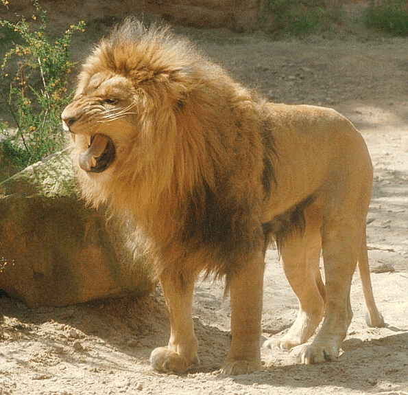
2. Von dieser Königin bekam dieser König eine Tochter. Die Zeichendeuter sagten voraus, dass sie mit dem König der Tiere1 Geschlechtsverkehr haben werde.
Kommentar:
1 d.h. dem Löwen
3. Atīva rūpini āsi,
atīva
kāmagiddhinī;
devena deviyā cāpi,
lajjāyāsi jigucchitā.
3. Sie war überaus schön und überaus liebestoll. König und Königin verachteten sie aus Scham.
4. Ekākinī sā nikkhamma,
sericārasukhatthinī;
satthena saha aññātā,
agā Magadhagāminā.
4. Allein ging sie fort von zuhause und suchte das Glück des freien Lebens. Unerkannt ging sie mit einer Karawane, die nach Magadha1 zog.
Kommnetar:
1 Magadha = heutiges Bihar (बिहार)
"Magadha One of the four chief kingdoms of India at the time of the Buddha, the others being Kosala, the kingdom of the Vamsas and Avanti. Magadha formed one of the sixteen Mahājanapadas and had its capital at Rājagaha or Giribbaja where Bimbisāra, and after him Ajātasattu, reigned. Later, Pātaliputta became the capital. By the time of Bimbisāra, Anga, too, formed a part of Magadha, and he was known as king of Anga Magadha (see, e.g., Vin.i.27 and ThagA.i.544, where Bimbisāra sends for Sona Kolivisa, a prominent citizen of Campā, capital of Anga). But prior to that, these were two separate kingdoms, often at war with each other (e.g., J.iv.454f).
Several kings of Magadha are mentioned by name in the Jātakas - e.g., Arindama and Duyyodhana. In one story (J.vi.272) the Magadha kingdom is said to have been under the suzerainty of Anga. In the Buddha's day, Magadha (inclusive of Anga) consisted of eighty thousand villages (Vin.i.179) and had a circumference of some three hundred leagues (DA.i.148).
Ajātasattu succeeded in annexing Kosala with the help of the Licchavis, and he succeeded also in bringing the confederation of the latter under his sway; preliminaries to this struggle are mentioned in the books (e.g., D.ii.73f., 86).
Under Bimbisāra and Ajātasattu, Magadha rose to such political eminence that for several centuries, right down to the time of Asoka, the history of Northern India was practically the history of Magadha. (A list of the kings from Bimbisāra to Asoka is found in Dvy.369 ; cp. DA.i.153; Mbv.96, 98).
At the time of the Buddha, the kingdom of Magadha was bounded on the east by the river Campā (Campā flowed between Anga and Magadha; J.iv.454), on the south by the Vindhyā Mountains, on the west by the river Sona, and on the north by the Ganges. The latter river formed the boundary between Magadha and the republican country of the Licchavis, and both the Māgadhas and the Licchavis evidently had equal rights over the river. When the Buddha visited Vesāli, Bimbisāra made a road five leagues long, from Rājagaha to the river, and decorated it, and the Licchavis did the same on the other side. DhA.iii.439 f.; the Dvy. (1p.55) says that monks going from Sāvatthi to Rājagaha could cross the Ganges in boats kept either by Ajātasattu or by the Licchavis of Vesāli.
During the early Buddhist period Magadha was an important political and commercial centre, and was visited by people from all parts of Northern India in search of commerce and of learning. The kings of Magadha maintained friendly relations with their neighbours, Bimbisāra and Pasenadi marrying each other's sisters. Mention is made of an alliance between Pukkusāti, king of Gandhāra and Bimbisāra. When Candappajjota of Ujjeni was suffering from jaundice, Bimbisāra sent him his own personal physician, Jīvaka.
In Magadha was the real birth of Buddhism (see, e.g., the words put in the mouth of Sahampatī in Vin.i.5, pātur ahosi Magadhesu pubbe dhammo, etc.), and it was from Magadha that it spread after the Third Council. The Buddha's chief disciples, Sāriputta and Moggallāna, came from Magadha.
In Asoka's time the income from the four gates of his capital of Pātaliputta was four hundred thousand kahāpanas daily, and in the Sabhā, or Council, he would daily receive another hundred thousand kahāpanas (Sp.i.52). The cornfields of Magadha were rich and fertile (Thag.vs.208), and each Magadha field was about one gāvuta in extent. Thus AA.ii.616 explains the extent of Kakudha's body, which filled two or three Māgadha village fields (A.iii.122).
The names of several places in Magadha occur in the books - e.g., Ekanālā, Nālakagāma, Senānigāma, Khānumata, Andhakavindha, Macala, Mātulā, Ambalatthikā, Pātaligāma, Nālandā and Sālindiya.Buddhaghosa says (SNA.i.135 f ) that there are many fanciful explanations (bahudhā papañcanti) of the word Magadha. One such is that king Cetiya, when about to be swallowed up by the earth for having introduced lying into the world, was thus admonished by those standing round - "Mā gadham pavisa;” another that those who were digging in the earth saw the king, and that he said to them: " Mā gadham karotha." The real explanation, accepted by Buddhaghosa himself, seems to have been that the country was the residence of a tribe of khattiyas called Magadhā.
The Magadhabhāsā is regarded as the speech of the āriyans (e.g., Sp.i.255). If children grow up without being taught any language, they will spontaneously use the Magadha language; it is spread all over Niraya, among lower animals, petas, humans and devas (VibhA.387f).
The people of Anga and Magadha were in the habit of holding a great annual sacrifice to Māha Brahmā in which a fire was kindled with sixty cartloads of firewood. They held the view that anything cast into the sacrificial fire would bring a thousand fold reward. SA.i.269; but it is curious that in Vedic, Brāhmana and Sūtra periods, Magadha was considered as outside the pale of Ariyan and Brahmanical culture, and was therefore looked down upon by Brahmanical writers. But it was the holy land of the Buddhists. See VT.ii.207; Thomas: op. cit., 13, 96.
Magadha was famous for a special kind of garlic (Sp.iv.920) and the Magadha nāla was a standard of measure. (E.g., AA.i.101).
Magadha is identified with the modern South Behar."
[Quelle: Malalasekera, G. P. <1899 - 1973>: Dictionary of Pāli proper names. -- Nachdruck der Ausgabe 1938. -- London : Pali Text Society, 1974. -- 2 vol. -- 1163, 1370 S. -- ISBN 0860132692. -- s. v.]
Magadha (मगध) was an ancient Indo-Aryan kingdom of India, mentioned in both the Ramayana and the Mahabharata. It was also one of the four main kingdoms of India at the time of Buddha, having risen to power during the reigns of Bimbisara (c. 544-491 BCE) and his son Ajatashatru (c. 491-460 BCE). The core of the kingdom was that portion of Bihar lying south of the Ganges, with its capital at Rajagriha (modern Rajgir). Magadha expanded to include most of Bihar and much of Bengal with the conquest of Anga, and then expanded up the Ganges valley annexing Kosala and Kashi. Magadha formed one of the sixteen so-called Mahājanapadas (Sanskrit, 'great country'). The Magadha empire included republican communities such as Rajakumara. Villages had their own assemblies under their local chiefs called Gramakas. Their administrations were divided into executive, judicial, and military functions. Bimbisara was friendly to both Jainism and Buddhism and suspended tolls at the river ferries for all ascetics after the Buddha was once stopped at the Ganges River for lack of money. History
There is little certain information available on the early rulers of Magadha. The most important sources are the Buddhist Chronicles of Sri Lanka, the Puranas, and various Buddhist and Jain holy texts. Based on these sources, it appears that Magadha was ruled by the Śiśunāga dynasty for some 200 years, c. 550 - 350 B.C.E. The Śiśunāga dynasty was overthrown by Ugrasena Mahāpadma Nanda, the first of the so-called nine Nandas (a.k.a. the Nanda or Nava Nanda dynasty). He was followed by his eight sons, whose names were (according to the Mahābodhivamsa) Panduka, Pandugati, Bhūtapāla, Ratthapāla, Govisānaka, Dasasiddhaka, Kevatta, and Dhana Nanda. According to the Sri Lankan Chronicles, the Nanda dynasty was in power for mere 22 years, while the Puranas state that Mahāpadma ruled for 28 years and his eight sons for only 12.
King Bimbisara of the Shishunaga dynasty led an active and expansive policy, conquering Anga in what is now West Bengal.
Siddhartha Gautama himself was born a prince of Kapilavatthu in Kosala around 563 BCE. As the scene of many incidents in his life, Magadha was a holy land.
After the death of Bimbisara at the hands of his son, Ajatashatru, the widowed princess of Kosala also died of grief, causing King Prasenajit to revoke the gift of Kashi and triggering a war between Kosala and Magadha. Ajatashatru was trapped by an ambush and captured with his army; but in a peace treaty he, his army, and Kashi were restored to Magadha, and he married Prasenajit's daughter.
Accounts differ slightly as to the cause of Ajatashatru's war with the Licchavi republic. It appears that Ajatashatru sent a minister, who for three years worked to undermine the unity of the Licchavis at Vaishali. To launch his attack across the Ganga River (Ganges), Ajatashatru had to build a fort at a new capital called Pataliputra, which the Buddha prophesied would become a great center of commerce. Torn by disagreements the Licchavis were easily defeated once the fort was constructed. Jain texts tell how Ajatashatru used two new weapons – a catapult and a covered chariot with swinging mace that has been compared to modern tanks.
In 326 BCE, the army of Alexander the Great approached the boundaries of Magadha. The army, exhausted and frightened by the prospect of facing another giant Indian army at the Ganges River, mutinied at the Hyphasis (modern Beas) and refused to march further East. Alexander, after the meeting with his officer, Coenus, was convinced that it was better to return, and turned south, conquering his way down the Indus to the Ocean.
Magadha was also the seat of the Mauryan Empire, founded by Chandragupta, which extended over nearly all India under Asoka; and, later, of the powerful Gupta Empire. The capital of the Mauryan Empire, Pataliputta (modern Patna), was begun as a Magadhan fortress and became the capital sometime after Ajatashatru's reign. Chandragupta destroyed the Nanda dynasty around 321 BCE, and became the first king of the great Mauryan Empire.
Kings of MagadhaA list of kings according to the Sri Lankan Chronicles follows:
- Bimbisāra (ruled for 52 years)
- Ajātaśatru (32 years; The Buddha is thought to have died in the 8th year of Ajātaśatru's reign.)
- Udāyin or Udāyibhadra (16 years)
- Anuruddha (c. 4 years)
- Munda (c. 4 years)
- Nāgadāsaka (24 years)
- Śiśunāga (18 years)
- Kālāśoka (28 years)
- Ten sons of Kālāśoka, Nandivardhana being the most prominent (22 years). The names for the other eight are given in the Mahābodhivamsa as follows: Bhaddasena, Korandavanna, Mangura, Sabbañjaha, Jālika, Ubhaka, Sañjaya, Korabya, and Pañcamaka.
The Puranas give a rather different list with long reigns, making the Śiśunāga dynasty 321 years long:
- Śiśunāga (ruled for 40 years)
- Kākavarna (26 years)
- Ksemadharman (36 years)
- Ksemajit or Ksatraujas (24 years)
- Bimbisāra (28 years)
- Ajātaśatru (27 years)
- Darśaka (24 years)
- Udāyin (33 years)
- Nandivardhana (40 years)
- Mahānandin (43 years)
This article incorporates text from the Encyclopædia Britannica Eleventh Edition, a publication now in the public domain."
[Quelle: http://en.wikipedia.org/wiki/Magadha. -- Zugriff am 2006-04-30]
"Bihar (बिहार in Devanagari) is a state of the Indian union situated in the eastern part of the country. Its capital is Patna [पटना]. Etymologically, the name Bihar derives from the Sanskrit Vihara which means abode. The Buddhist Vihara, which were the abode of the Buddhist monks, dotted the area in the ancient and medieval periods. To Bihar's north is the Kingdom of Nepal [नेपाल अधिराज्य]. On its other three sides Bihar is surrounded by the Indian states of Uttar Pradesh [Hindi: उत्तर प्रदेश, Urdu: اتر پردیش] to the west, Jharkhand [झारखंड] to the south and West Bengal [পশ্চিম বঙ্গ] to the east. Bihar lies in the very fertile Gangetic plains. Culturally, it is a part of the Hindi [हिन्दी] heartland of India. Bihar has the notorious reputation of being India's most lawless state.
HistoryAncient
Bihar has a very rich history. It was called Magadha in ancient times. Its capital Patna, then known as Pataliputra, was the center of the Mauryan empire, which dominated the Indian subcontinent from 325 BC to 185 BC. Emperor Ashoka was the most famous ruler of this dynasty. Bihar remained an important place of power, culture and education during the next one thousand years. The Vikramshila and Nalanda Universities, now defunct, were one of the oldest and best centres of education.Religions Originating in Bihar
Bihar is the birthplace of many religions, including Buddhism and Jainism. Buddha attained Enlightenment at Bodh Gaya [बोधगया], a town located in the modern day district of Gaya [गया]. Mahavira [वर्धमान महावीर], the founder of Jainism, was born in Vaishali. The word "Bihar" has its origin in the Sanskrit word Vihara meaning Buddhist Monasteries. At one time these "viharas" were strewn all over the landscape of Bihar, around villages and cities.Medieval
With the advent of foreign aggression and the eventual foreign subjugation of India, the position of Bihar also was adversely affected. Muhammad Bin Bakhtiar Khilji, a General of Muhammad Ghori [محمد شہاب الدین غوری] captured Bihar in 12th century. Bihar saw a brief period of glory for six years during the rule of Sher Shah Suri [شیر شاه سورى], who was from Sasaram and built the longest road of the Indian subcontinent, the Grand Trunk Road, which starts from Calcutta [কলকাতা] and ends at Peshawar [پیشاور] in Pakistan. During 1557-1576, Akbar [جلال الدین محمد اکب], the Mughal [دولتِ مغل] emperor, annexed Bihar and Bengal to his empire and made Bihar a part of Bengal. With the decline of Mughals, Bihar passed under the control of the Nawabs [نواب] of Bengal.Modern
After the Battle of Buxar (1765), the British East India Company obtained the diwani rights (rights to administer and collect revenue, or tax administration / collection) for Bihar, Bengal and Orissa. From this point onwards, Bihar remained a part the Bengal Presidency of the British Raj until 1912, when Bihar was carved out as a separate province. In 1935, certain portions of Bihar were reorganised into the separate province of Orissa. Again, in 2000, 18 administrative districts of Bihar were separated to form the state of Jharkhand.Babu Kunwar Singh of Sasaram and his army, as well as countless other persons from Bihar, contributed to the India's First War of Independence (1857), also called the Sepoy Mutiny by some historians.
After his return from South Africa, Mahatma Gandhi [મોહનદાસ કરમચંદ ગાંધી] started the freedom movement in India by his satyagraha in the Champaran district of Bihar -- against the British, who were forcing the local farmers to plant indigo which was very harmful to the local soil. This movement by Mahatma Gandhi received the spontaneous support of a cross section of people, including Dr. Rajendra Prasad [डाक्टर राजेन्द्र प्रसाद], who ultimately became the first President of India.Timeline
- 560-480 BCE: Anga, Buddha
500 BCE: Foundation of world's first republic in Vaishali.- Before 325 BCE: Anga, Nanda clan in Magadha, Licchavis in Vaishali
325-185 BCE: Maurya Dynasty- 250 BCE: 3rd Buddhist Council
185 BCE-80 CE: Sunga Dynasty- 80 - 240: Regional kings
240 - 600: Gupta Dynasty- 600 - 650: Harsha Vardhana
750 - 1200: Pala Dynasty- 1200: Muhammad of Ghori's army, destroys the universities at Nalanda and Vikramshila
- 1200-1250: Decline of Buddhism
- 1250-1526: Ruled by Delhi Sultanate (Muslim Turks - Tughluqs, Sayyids, Lodis)
1526-1540: Babur defeats last Delhi sultan, establishes Mughal Empire- 1540-1555: Suri dynasty captures empire from Mughals (including Shershah Suri who built the Grand Trunk Road)
- 1526-1757: Mughal dynasty resumes
- 1757-1857: British East India Company rule
- 1857: Revolt of 1857
1857-1947: British Raj rule- 1912: Province of Bihar & Orissa separated from Bengal
- 1935: Bihar and Orissa become separate provinces
- 1947: Indian Independence; Bihar becomes a state
- 2000: Bihar divided into two states - north part remains "Bihar", southern becomes Jharkhand
Geography Bihar is mainly a vast stretch of very fertile flat land. It has several rivers: Ganga, Son, Bagmati, Kosi, Budhi Gandak, and Falgu to name a few. Central parts of Bihar have some small hills, for example the Rajgir hills. The Himalayan mountains are to the north, in Nepal. To the south is the Chota Nagpur plateau, which was part of Bihar until 2000 but now is part of a separate state called Jharkhand.
Geography & climateClimate: Bihar is mildly cold in the winter (the lowest temperatures being around 5 to 10 degrees Celsius; 41 to 50 degrees Fahrenheit). Winter months are December and January. It is hot in the summer (40 to 45 degrees Celsius; 104 to 114 degrees Fahrenheit). April, May and the first half of June are the hot months. The monsoon months of June, July, August, and September see good rainfall. October, November, February, and March are very pleasant months for climate.
EconomyBihar's gross state domestic product for 2004 is estimated at $19 billion in current prices.
There was a division of Bihar in 2000, when the industrially advanced and mineral-rich southern-half of the state was carved out to form the separate state of Jharkhand. Since then, the main economic activity of Bihar has been agriculture. The new Bihar state produces about 60% of the output of the old Bihar state.
Bihar is among the least developed states of India and has a per capita income of $94 a year against India's average of $255. A total of 42.6% live below the poverty line against India's average of 26.1%. The blame for this stems from many factors: a historical neglect from the center of Indian power, lack of vision of the political classes, and inadequate investments in agriculture, infrastructure and education. Many people believe that mis-rule, caste-dominated politics and rampant corruption by politicians have been the cause of the poverty in the state.The economy is mainly based on agricultural and trading activities. The vast swath of extremely fertile land makes it ideal for agriculture. Despite a number of rivers and good fertile soil, investment in irrigation and other agriculture facilities has been grossly inadequate. Agriculture is mainly dependent upon the vagaries of the nature.
Recently the dairy industry has picked up very well in Bihar. There also have been some attempts to industrialize the state: an oil refinery in Barauni, a motor scooter plant at Fatuha, a power plant at Muzaffarpur and some agriculture-based industries such as sugar and vegetable oil. However no sustained effort has been made in this direction, and there is little success in its industrialization.Government & politics
Nominally Bihar is headed by a Governor, who is appointed by the President of India. The real executive power rests with the Chief Minister and the cabinet. The political party or the coalition of political parties having a majority in the Legislative Assembly forms the Government.The head of the bureaucracy of the State is called the Chief Secretary. Under him is a hierarchy of officials drawn from the Indian Administrative Service, Indian Police Service, and different wings of the State Civil Services.
The judiciary is headed by the Chief Justice. Bihar has a High Court which has been functioning since 1916.All the branches of the government are located in the state capital, Patna.
See List of political parties in the state
AdministrativeThe state is divided into 9 divisions and 37 districts, for administrative purposes.
- See also
Transport & travel
- Divisions of Bihar
- Districts of Bihar
Bihar has three airports - Lok Nayak Jayaprakash Airport, Patna, Bhagalpur Airport and Gaya. Patna airport is connected to Delhi, Mumbai, Kolkata, Lucknow, and Ranchi. It is categorised as a restricted international airport, with customs facilities to receive international chartered flights. Gaya airport is a small international airport connected to Colombo and Bangkok.
Bihar is well-connected by railway lines to the rest of India. Most of the towns are interconnected among themselves, and they also are directly connected to Kolkata, Delhi and Mumbai. Patna, Bhagalpur and Gaya are Bihar's best-connected railway stations.The state has a vast network of National and State highways. However the roads are not in good condition.
For Buddhist pilgrims, the best option for travel to Bihar is to reach Patna or Gaya, either by air or train, and then travel to Bodh Gaya, Nalanda, Rajgir and Vaishali. Sarnath in Uttar Pradesh also is not very far.Places to See
Culture
- Buddhist sites - Bodh Gaya, Nalanda, Rajgir, Vaishali, Bhagalpur , Vikramshila ,Sultanganj.
- Jain sites - Vaishali and Pawapuri, Bhagalpur.
- Sikh sites - Har Mandir Sahib, Patna City, the birth place of Guru Gobind Singh.
- Hindu sites - Sultanganj(Bhagalpur), Vishnu Pad temple at Gaya, Konch Shiva Temple, Baidyanath Dham, Tara Mandir at Mahisi, Patan Devi at Patna, Sun Temple at Deoghar, near Aurangabad, Varah Temple at Harihar Kshetra, Shiv temple at singhesarsthan(Madhepura).
- Muslim sites - Bihar-E-Sharif, [Sultanganj], Bhagalpur.
- Historic sites - The landscape is dotted with historic sites. Important ones are Patna, Bhagalpur Gaya, Bodh Gaya, Nalanda, Rajgir, Vaishali, Pawapuri, Champaran, and Sasaram.
- Sanjay Gandhi Jaivik Udyaan, Patna.
Festivals
Folksongs & music
- Chhath, also called Dala Chhath - is a major festival in Bihar, and is celebrated a week after Deepawali. Chhath is the worship of the Sun God. Wherever people from Bihar have migrated, they have taken with them the tradition of Chhath, and now this festival is known even in a metropolis like Calcutta, or New Delhi or Mumbai. Teej and Chitragupta Puja are other local festivals celebrated with fervour in Bihar.
Among other festivals the Shravani Mela of Sultanganj is of great importance. Shravani Mela is organised every year in July-August. Bihula-Bishari Puja of Anga region also is a great festival of Bihar.- Sonepur cattle fair held approx 15 days after diwali is the largest cattle fair in Asia
- Apart from Chhath, all major festivals of India are celebrated in Bihar, such as Makar Sankranti, Sarasawati Puja, Holi, Eid-ul-Fitr, Eid-ul-Adha (often pronounced Eid-uz-Zoha in South Asia), Muharram, Ram Nawami, Rath yatra, Rakhi, Mahashivaratri, Durga Puja, Divali, Laxmi Puja, Christmas, Mahavir Jayanti, Buddha Purnima
Main article: Music of Bihar
Bihar has a very old tradition of beautiful folk songs, sung during important family occasions, such as marriage, birth ceremonies, festivals, etc. They are sung mainly in group settings without the help of any musical instruments.
Bihar also has a tradition of lively Holi songs, filled with fun rhythms.
During the 19th century, when the condition of Bihar worsened as a rule British misrule, many Biharis had to migrate as indentured labourers to West Indian islands, Fiji, and Mauritius. During this time many sad plays and songs called biraha became very popular, in the Bhojpur area, and dramas on that theme continue to be popular in the theaters of Patna.
Dances of Bihar
Dance forms of Bihar are another expression of rich traditions and ethnic identity. There are several folk dance forms that can keep one enthralled, such as dhobi nach, jhumarnach, manjhi, gondnach, jitiyanach, more morni, dom-domin, bhuiababa, rah baba, kathghorwa nach, jat jatin, launda nach, bamar nach, jharni, jhijhia, natua nach, bidapad nach, sohrai nach, and gond nach.
Language & Literature
Hindi [हिन्दी ], Urdu [اردو], Angika, Bhojpuri [भोजपुरी], Maithili [मैथिली], and Magadhi [मागधी] (Magahi [मगही]). are the major languages spoken in Bihar.Angika is the only one of the languages which can be used in the Google Search Engine, Google-Angika has been available since 2004. The oldest poetry of the Hindi language (e.g., poetries written by Saraha, also known by the name Sarahapa, were written in the Angika language during the 8th century.
Bihar has produced a number of writers of Hindi, including Raja Radhika Raman Singh, Shiva Pujan Sahay, Divakar Prasad Vidyarthy, Ramdhari Singh 'Dinkar' [रामधारी सिंह दिनकर], Ram Briksha Benipuri, Phanishwar Nath 'Renu' [फणीश्वर नाथ रेणु]. Different regional languages also have produced some prominent poets and authors.Devaki Nandan Khatri, who rose to fame at the beginning of the 20th century on account of his novels such as Chandrakanta and Chandrakanta Santati, was born in Muzaffarpur, Bihar.
Vidyapati the great Maithli Poet, son of ganga has contributed in various direction of maithili literature, also has composed the most popular songs of all time
Folk TheatreTheatre is another form in which the Bihari culture expresses itself. Some forms of theater with rich traditions are Reshma-Chuharmal, Bihula-Bisahari, Bahura-Gorin, Raja Salhesh, Sama Chakeva, and Dom Kach. All of these theatre forms originate in the Anga or Ang area of Bihar.
CinemaBihar has a robust cinema industry for the Bhojpuri language. There also is a small Maithili film industry.
Multimedia Films: AUPS MULTIMEDIA is working on various multimedia projects on glorious culture and life style of Bihar. The ancient golden history of Bihar has to be shown via Film, Documentary and Multimedia Films.
[edit]Cuisine
Main Article Cuisine of Bihar
The cuisine of Bihar is predominantly vegetarian. However unlike Gujarat or some communities of the South, non-vegetarian food has been acceptable in the society of Bihar, as well, with even some sects of Brahmins such as the Mithila accepting fish as a food item. Traditional Bihar society did not eat eggs and chicken, although other types of birds and fowls were acceptable.
The staple food is “bhat, dal, roti, tarkari and achar”, prepared basically from rice, lentils, wheat flour, vegetables, and pickle. The traditional cooking medium is mustard oil. "Kichdi", a broth of rice and lentils seasoned with spices and served with several accompanying items, constitutes lunch for Biharis on Saturdays.
Chitba and Pitthow which are prepared basically from rice, are special foods of the Anga region. Tilba and Chewda of Katarni rice also are special preparations of Anga.Bihar offers a large variety of sweet delicacies which, unlike those from Bengal, are mostly dry. These include Anarasa, Belgrami, Chena Murki, Motichoor ka Ladoo, Kala Jamun, Kesaria Peda, Khaja, Khurma, Khubi ka Lai, Laktho, Parwal ki Mithai, Pua & Mal Pua, [Thekua], Murabba and Tilkut. Many of these originate in towns in the vicinity of Patna.
Several other traditional salted snacks and savouries popular in Bihar are Chiwra, Dhuska, Litti, Makhana and Sattu.
There is a distinctive Bihari flavor to the non-vegetarian cooking, as well, although some of the names of the dishes may be the same as those found in other parts of north India. Roll is a typical Bihar non-vegetarian dish. These are popular and go by the generic name "Roll Bihari", in and around Lexington Avenue (South) in New York City.
ArtManjusha Kala or Angika Art of Anga Region, Madhubani Art of Mithila Region, Patna Kalam of Magadha Region.
Education
Historically, Bihar has been a major centre of learning, home to the universities of Nalanda (one of the earliest institutes in India) and Vikramshila. Modern Bihar has an acutely-inadequate educational infrastructure, creating a problem compounded by a growing population. This has prompted many students to seek educational opportunities in other states, such as New Delhi and Karnataka, especially for college education.
Bihar has the highest illiteracy rate in India, with women's literacy being only 33.57 %. With the exception of a few leading private schools, the overall standard of education in Bihar today is considered to be poor.
AUPS MULTIMEDIA is working for the betterment of education and implementing technology in education in Bihar. Proper use of modern science, technology and managemnet of the western world in accordance with Indian culture and civilization will produce the capable mind which can help and handle to manage the global world with peace and can also support the balanced developement with the spirit of VASUDHAIV KUTUMBKAM.
Schools
Bihar has a system of district schools (called Zila schools), located at the headquarters of older districts of Bihar. During the early 1980s the state government took over management of most privately-run schools, and accorded them government recognition. As in other states, the central government runs a number of Kendriya Vidyalayas (Central Schools) and Jawahar Navodaya Schools for rural students. Private schools, including school-chains and Missionary Schools, also exist. Most of the government-run schools in Bihar are affiliated with the Bihar School Examination Board, whereas most of the private schools are affiliated with the ICSE and CBSE boards."
[Quelle: http://en.wikipedia.org/wiki/Bihar. -- Zugriff am 2006-05-13]
5. Lāḷaraṭṭhe aṭaviyā,
sīho
sattham abhiddhavi;
aññattha sesā dhāviṃsu,
sīhagatadisan tu sā.
5. In einem Wald im Lāḷareich1 überfiel ein Löwe2 die Karawane. Alle übrigen liefen wo anders hin, sie aber lief in die Richtung, aus der der Löwe gekommen war.
Kommentar:
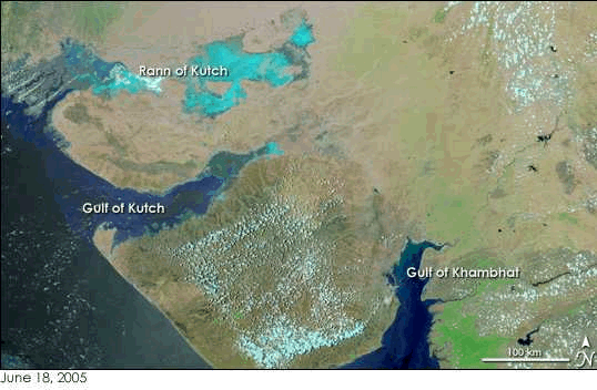
1 Lāḷareich: wird in das heutige Gujarat (ગુજરાત) verlegt, da Ptolemäus dort ein Larika nennt; allerdings verträgt sich das kaum mit der Tatsache, dass die Karawane nach Magadha zog, andrerseits ist weitläufige Topographie sehr schwer zu durchschauen, wie sich auf europäischen Karten bis ins 19. Jhdt. zeigt.
"Gujarat (Gujarati: ગુજરાત, Hindi: गुजरात, Gujarāt, IPA [guɟra:t]; also spelled Gujrat and sometimes Gujarath). Guzarat is a Western phonetic corruption, and is not considered an official term. Gujarat contains many of the former Princely states of India, and is the second-most industrialized state in the Republic of India after Maharashtra. Gujarat borders Pakistan, and the states of Rajasthan to the north-east, Madhya Pradesh to the east, Maharashtra and the Union territory of Dadra and Nagar Haveli to the south. The international border with Pakistan is to the north-west. The Arabian Sea makes up the state's western coast. Its capital is Gandhinagar, a planned city which is close to Ahmedabad [અમદાવાદ], the former state capital and the current commercial center of Gujarat. History
Gujarat Civilization begins as the Indus Valley CivilizationSituated on the western coast of India, the name of the state is derived from Gujjarātta (Gurjar Rāshtra), which means the land of the Gujjars or Khazars. It is believed that a tribe of Gujjars migrated to India around the 5th century. The history of Gujarat, however, began much earlier. Settlements of the Indus Valley Civilization, also known as the Harappan Civilization, have been found in the area now known as Gujarat. Gujarat's coastal cities, chiefly Bharuch, served as ports and trading centres for the Maurya and Gupta empires. After the collapse of the Gupta empire in the 6th century, Gujarat flourished as an independent Hindu kingdom. The Maitraka dynasty, descended from a Gupta general, ruled from the 6th to the 8th centuries from their capital at Vallabhi, although they were ruled briefly by Harsha during the 7th century. The Arab rulers of Sind sacked Vallabhi in 770, bringing the Maitraka dynasty to an end. A branch of the Pratihara clan ruled Gujarat after the eighth century. In 775 the first Parsi (Zoroastrian) refugees arrived in Gujarat from Iran.
960 AD to 1292 ADThe Solanki clan of Rajputs ruled Gujarat from c. 960 to 1243. Gujarat was a major center of Indian Ocean trade, and their capital at Anhilwara (Patan) was one of the largest cities in India, with a population estimated at 100,000 in the year 1000. In 1026, the famous Somnath temple in Gujarat was destroyed by Mahmud of Ghazni [محمود غزنوی]. After 1243, the Solkanis lost control of Gujarat to their feudatories, of whom the Vaghela chiefs of Dholka came to dominate Gujarat. In 1292 the Vaghelas became tributaries of the Yadava dynasty of Devagiri in the Deccan.
1297 AD to ~1850 ADIn 1297 to 1298 Ala ud din Khilji [علاء الدین خلجی], Sultan of Delhi, destroyed Anhilwara and incorporated Gujarat into the Delhi Sultanate. After Timur's [تیمور] sacking of Delhi at the end of the 14th century weakened the Sultanate, Gujarat's Muslim governor Zafar Khan Muzaffar asserted his independence, and his son, Sultan Ahmed Shah (ruled 1411 to 1442), established Ahmedabad as the capital. Cambay eclipsed Bharuch as Gujarat's most important trade port. The Sultanate of Gujarat remained independent until 1576, when the Mughal emperor Akbar [جلال الدین محمد اکب] conquered it and annexed it to the Mughal Empire. It remained a province of the Mughal empire until the Marathas conquered eastern and central Gujarat in the 18th century; Western Gujarat (Kathiawar and Kutch) were divided among numerous local rulers.
1614 to 1947Portugal was the first European power to arrive in Gujarat, acquiring several enclaves along the Gujarati coast, including Daman and Diu and Dadra and Nagar Haveli. The British East India Company established a factory in Surat [સુરત] in 1614, which formed their first base in India, but it was eclipsed by Bombay [मुंबई] after the British acquired it from Portugal in 1668. The Company wrested control of much of Gujarat from the Marathas during the Second Anglo-Maratha War. Many local rulers, notably the Maratha Gaekwads of Baroda (Vadodara), made a separate peace with the British, and acknowledged British sovereignty in return for retaining local self-rule. Gujarat was placed under the political authority of Bombay Presidency, with the exception of Baroda state, which had a direct relationship with the Governor-General of India. From 1818 to 1947, most of present-day Gujarat, including Kathiawar, Kutch, and northern and eastern Gujarat were divided into dozens of princely states, but several districts in central and southern Gujarat, namely Ahmedabad, Broach (Bharuch), Kaira, Panch Mahals, and Surat, were ruled directly by British officials.
Indian Independence MovementThe people of Gujarat were the most enthusiastic participants in India's struggle for freedom. Leaders like Mahatma Gandhi [મોહનદાસ કરમચંદ ગાંધી], Sardar Vallabhbhai Patel [સરદાર વલ્લભભાઈ પટેલ], Morarji Desai [मोरारजी देसाई], K.M. Munshi, Narhari Parikh, Mahadev Desai, Mohanlal Pandya and Ravi Shankar Vyas all hailed from Gujarat. In addition, Mohammed Ali Jinnah [محمد على جناح], Pakistan's first Governor-General, spoke Gujarati as his mother tongue and his father was from what later became Gujarat. Gujarat was also the site of some of the most popular revolts, including the Satyagrahas in Kheda, Bardoli, Borsad and the Salt Satyagraha.
Province Consolidation and Division after 1947After India's independence in 1947, 217 princely states of Kathiawar and Saurashtra, including the former kingdom of Junagadh, were grouped together to form the province of Saurashtra, with its capitol at Rajkot. On November 1, 1956, Saurashtra was merged into Bombay State. The modern state of Gujarat was created on May 1, 1960, out of the northern, predominantly Gujarati-speaking portion of Bombay State. The southern, predominantly Marathi-speaking portion became the state of Maharashtra [महाराष्ट्र].
Post IndependenceAfter Indian independence and the partition of India in 1947, the new Indian government grouped the former princely states of Gujarat into three larger units; Saurashtra, which included the former princely states on the Kathiawar peninsula, Kutch, and Bombay state, which included the former British districts of Bombay Presidency together with most of Baroda state and the other former princely states of eastern Gujarat. In 1956, Bombay state was enlarged to include Kutch, Saurashtra, and parts of Hyderabad state and Madhya Pradesh in central India. The new state had a mostly Gujarati-speaking north and a Marathi-speaking south. Agitation by Marathi nationalists for their own state led to the split of Bombay state on linguistic lines; on 1 May 1960, it became the new states of Gujarat and Maharashtra. The first capital of Gujarat was Ahmedabad; the capital was moved to Gandhinagar in 1970.
In Gujarat a few new towns have been established since Indian independence in 1947. Most of these are more like settlements established near existing urban centres. Gandhidham, Sardarnagar and Kubernagar are three rehabilitation towns more like refugee settlements than self-sufficient towns. The last two now form part of the city of Ahmedabad. Ankleswar and Mithapur were two of the earlier industrial towns established in Gujarat. A complex of three small townships for the oil refinery, the Fertilizer Factory and Petro-chemicals plant also came up near Vadodara. Kandla is the only new port town established in the state.
2001 Gujarat EarthquakeGujarat was hit with a devastating earthquake on January 26, 2001 at 9:00, which claimed a staggering 20,000 lives, injured another 200,000 people and severely affected the lives of 40 million of the population. The economic and financial loss to Gujarat and India is being felt even after almost half a decade.
2002 Gujarat RiotsThe term 2002 Gujarat violence refers to the riots which were triggered on February 27, 2002 by a vicious attack on a passenger train, the Sabarmati Express, passing through the town of Godhra. The train was forcibly stopped and attacked at Signal Falia near Godhra Junction. Ladies Coach S6 bore the brunt of mob attack. In the midst of attack, Coach S6 caught fire killing 59 passangers, most of whom were women and children.
Many train passengers were Hindu activists and pilgrims called Kar Sevaks returning from a disputed religious site located in holy city of Ayodhya. The train was allegedly set to fire by Muslim extremists. Hindu sympathisers often cite this as the primary provocation or the "first use" of violence. However, Muslim sympathisers allege that hindus riding the train were shouting hindu-religious slogans. As a result, Muslims attacked the train.
Two years after the incident Railway Minister Lalu Prasad Yadav appointed Justice Banerjee to investigate the cause of fire. On the eve of election in Railway Minister's Native State Bihar, Justice Banerjee submitted an interim report concluding that the fire and attack are two separate events. It claimed, very controversially, that the fire was likely started from within the train, and not by a mob gathered outside the train This interim report and Bin Laden Clones were used in Bihar Election to attract Muslim votes. The Interim Report's credibilty is in serious doubt due to timing of it's release and subsequent use in election campaigning
Geography
Geography of Gujarat. Courtesy: NASA Earth ObservatoryGujarat is the westernmost state of India. It is bounded by the Arabian Sea to the west and southwest, and Pakistan to the north. The state of Rajasthan is to the northeast, Madhya Pradesh to the east, and Maharashtra and the union territory of Dadra and Nagar Haveli to the south and southeast of Gujarat.
Climate & Natural FeaturesThe relief is low in the most parts of the state and involves diverse climate conditions. Though mostly dry, it is desertic in the north-west, and wet in the southern districts due to heavy monsoon season. With the construction of Sardar Sarovar on Narmada River, a result of the largest dam in India, irrigation facilities have improved immensely, with water being provided to the most dry areas of Kutch and Saurashtra through a 550 km long canal, an engineering marvel. With the Gulf of Kutch and the Gulf of Cambay, Gujarat has about 1600 km of coastline, which is the longest coastline of all Indian states.
RiversThe major rivers flowing through the state include the Narmada, Sabarmati, and Mahi in central and northern Gujarat; Mithi, Khari, and Bhogavo in Saurashtra; Tapi, Purna, Ambika, Auranga and Damanganga in the southern part of the state.
National ParksGujarat is home to four National Parks, including Gir Forest National Park, near Junagadh, Blackbuck National Park in Bhavnagar District, Vansda National Park in Navsari District, and Marine National Park on the Gulf of Kutch in Jamnagar District. The last remaining Asian lions, famous for their dark black manes, live in the area surrounding Girnar. In addition to these, there are twenty one Wildlife sanctuaries.
Major CitiesThe major cities in Gujarat are Ahmedabad [અમદાવાદ], Vadodara (Baroda), Surat [સુરત], Rajkot and Jamnagar. Ahmedabad, the commercial capital of the state, is the sixth largest city of India. Other important cities include Nadiad, Anand and Ankleshwar in central Gujarat, Bharuch, Navsari, Vapi, and Valsad in the south; and Bhuj, and Dwarka in Saurastra in the west."
[Quelle:http://en.wikipedia.org/wiki/Gujarat. -- Zugriff am 2006-05-08]
Eine andere Hypothese bringt die ganze Geschichte mit den Kamboja in Verbindung. Obwohl die folgende Konstruktion m.E. einer kritischen Überprüfung nicht voll standhält, soll sie hier in vollem Umfang als alternative Meinung voll zitiert werden:
"Kamboja Colonists of Sri Lanka Sri Lanka (formerly known as Ceylon or Lanka) is a tropical island nation off the southeast coast of the Indian subcontinent, about 31 kilometres (18.5 mi) south of India. Many ancient Indian Sanskrit and Pali texts refer to this island as Sinhala or Simhaladvipa. The Arab and the Purtughese traders corrupted the name to Seilan Ceylone and Ceilão etc. In English, the name is written as Sinhalese or Singhalese. The Sinhala also refers to about 74% of the population speaking the Sinhala language which belongs to the Indo-Aryan family and is closely allied to the Sanskrit, Pali and Prakrit. The earliest colonists of Sri Lanka migrated from northern India but controversy exists as to the provenance of the early colonists; the traditions contain evidence for both the northwestern and the northeastern parts of the Indo-Gangetic plain. The first colonists, in all probability, hailed from the Saurashtra in Gujarat. Their ancestors are believed to have migrated earlier from Sinhapura of upper Indus near Kamboja/Gandhara region to the Saurashtra peninsula in Gujarat via lower Indus. Before arriving in Sri Lanka, these earliest known colonists called at Soparaka located on the west coast of India and landed in Sri Lanka at Tambapanni, near Puttalam on the day of on the day of Parinibhana (decease) of the Buddha (542 BCE or 486 BCE).
Ancient Kamboja : The Hub of Interantional TradeAncient Kambojas were originally located in trans-Hindukush region in Pamirs and Badakshan. Later, sections of them crossed Hindukush and occupied Kunar and Swat valleys north of river Kabol in Cis-Hindukush area. With time, the trans-Hindukush section of the Kambojas became known as Parama-Kambojas while cis-Hindukush settlements became known as Kamboja [1]. Important Caravan routes such as the well known Uttarapatha Caravan route (from Bahlika-Kamboja to Pataliputra-Tamralipitika) and the Kamboja Dvaravati Caravan route (from Kamboja to Dwaraka in Surashtra) originated from Kamboja/Gandhara/Bahlika region which connected these communities to eastern and western parts of ancient India. Third important route originating from Kamboja is referred to by Sanskrit poet Kalidasa in his Raghuvamsa and it ran from Pamir/Badakshan to Trigarta, Rampur-Bushahar Kinnara, Nepal and to Kamarupa/Assam.[2] After reaching west or east coast of India, the merchants from Gandhara, Bahlika, Kamboja, Kashmira were connected by sea routes to important places like Persian gulf, southern India, Sri Lanka, Burma and the countries of the Far East. Ancient Buddhist text Petavathu, (Commentary) also attests that ancient Kamboja was located on one of the great caravan routes, and there was a road direct from Dvaraka to Kamboja [3]. Besides, other Caravan routes leading to Persia in the south-west, to Blacksea in the north-west, to Siberi in the north and to China (china Silk route) in the north-east also joined at Kamboja/Bahlika region. Thus the Kamboja indeed formed the hub of international trade. This is the reason some ancient references attest the Kambojas as a community of traders.
Kambojas: The Documented TradersAncient Sanskrit texts like Kautiliya’s Arthashastra, Brhat-samhita, Mahabharata and Ramayana etc amply attest that, apart of being a formidable warriors (Shastr-opajivins = Nation-in-arms), the ancient Kambojas were also noted as excellent traders, agriculturists and cattle-culturists (varta-opajivins= Traders and agriculturists ).
- Kautilya's Arthashastra lists the Kambojas with Saurashtras and says that same form of politico-economic constitutions (varta-shastr.opajivin) obtained in these two ancient martial republics. It attests both of them to be living by warfare, trade, agriculture and cattle-culture [4]
- The Brhat-Samhita of Varaha Mihira also attests that the Kambojas were a shastra-vartta nation i.e living by warfare, trade, agriculture and cattle-culture. [5]
Mahabharata also verifies the fact that the Kambojas lived by warfare and varta when it states the Kambojas to be “as terrible as Yama” (i.e. god of death) in warfare and “as rich as Kubera” (i.e. the god of treasure). [6]
Shipping Communities from NorthwestThe Periplus of the Erythraean Sea makes mention of several sea ports beginning with Barbaricum at the mouth of river Indus, followed by Barygaza (Bharukachcha, modern Bharoch), Soparaka (Sopara), Calliena (Kalyan) and Muziris (in Kerala) etc all located along the the west coast of India southwards. Besides these more important sea-ports, there were also lesser ports like Sindan, Dvaravati, Cambay (Khambat), Kamboika (Kambojika –a landlocked port) and the Gandhar (near Bharukachcha) etc. The important international ports of Barbaricum, Bharukachcha, Dvaravati, and Soparaka were easily accessible to the traders from north-west for international trade and the merchants from Kamboja, Gandhara, Kashmira, Sindhu, Sauvira, and Saurashtra used to sail from these ports on the country’s western coast. Huge trade ships carrying merchandise from Kamboja, Gandhara, Kashmira, Sindhu, Sovira, Saurashtra etc are said to have been launching from these ports directly to southern India, Sri Lanka, south Myanmar and Suvarnabhumi. [3]. The ports of Gandhara and Kamboika located in south-east Saurashtra probably also served as residential headquarters for the traders from Gandhara and Kamboja.
Early Buddhist literary sources from north India refer to the northerners including the Kambojas, Kashmiras, Gandharas as being involved in trade in horses [7].
There is a Buddhistic reference to a trader and Arhant named Bahya who was native of Bharukachcha (modern Bhroach) in south-east Sauarashta/Gujarat [8]. He engaged himself in trade, voyaging in a sea ship. Seven times he sailed down the river Indus and across the sea and returned safely home. On the eighth occasion, while on his way to Suvarnabhumi, his ship was wrecked, and he floated ashore on a plank, reaching land near Soparaka [9]. This ancient Buddhist evidence powerfully verifies that the trade ships plied regularly between (1) upper Indus countries of Kamboja, Gandhara, Kashmira group and the sea ports of Bharukachcha and Soparaka and (2) from Bharukachcha/Soparaka to Sri Lanka, Suvarnabhumi and probably further to the Far East.Buddhist Jatakas also amply attest that there was a regular trade between Bharukaccha, Soparaka and Suvarnabhumi [10]
Evidence exists that horse merchants from Kamboj were in active trade with eastern India, southern India, western India and as far as Ceylon. This trade had been going as late as medieval ages. King Devapala (810-850 CE) of Bengal, king Vishnuvardhana of Hoysala dynasty (1106 - 1152 CE) of Mysore and king Vallabhadeva of Pandya kingdom (12th century CE) located in extreme southern tip of India, had powerful fleets of Kamboja horses in their cavalry.
Dr Don Martino observes: 'The traders from north-west Kamboja had been conducting trade in horses with Sri Lanka following west coast of India since remote antiquity' [11].
Dr E. Muller also says: "… (with time) the Kambojas had adopted the Mussalman creed and used to trade all along the west coast of India from Persian Gulf down to Ceylone and probably further-east…" [12]'The diffusion of Indian Civilization and its "great tradition" to the extreme south of the peninsula occurred in the earliest stages not by land but by sea......In the half millennium before Christ there was sea traffic between the coasts of Gujarat and Sind [Sindhi: سنڌ ;Urdu: سندھ], and Ceylon, which laid the basis for the development of civilization in that island...... The earliest attractions of the far southern coasts were pearls and gems, which brought merchants, and ultimately the script, religions and the dynastic traditions.....Hiun Tsang refers to the international trading activities of the Simhalas and several early Brahmi inscriptions in Ceylon mention the Kamboja merchants in Sinhala' [13].
Kambojas in Sri LankaInscriptional, archaological and literary evidence exists which sufficientlt proves that the merchant class from Kambojas, Yonas and some other communities of northwest had reached Sri Lanka and settled there centuries prior to Christian era.
Inscriptional EvidenceSinhalese inscriptions from Koravakgala at Situlpahuwa in the Hambantota district contain the word "Kaboja"' (Sanskrit: Kamboja) [14]. Another epigraphic inscription found from Kaduruvava in Kurunagala District attest the existence of one 'Kamboja Sangha' (Gote-Kabojhyana) [15]. There is yet another important cave inscription located in Bovattagala in Anuradhapura which attests one 'Grand Trade Guild of the Kambojas' (Kabojhya Mahapugyana) [16]. A Mediaeval era Inscription found from Polonnaruva in 1887 near Vishnu Temple relates to Maharaja Kalinglankeshwara Bahu Veer-raja Nissanka-Malla Aprati Malla Chakravarati who caused one Charity House to be constructed and named after him as Nissankamalla-Daan-Griha. The southern gate of this Charity House is named as Kamboja Vasala.[17] And lastly, an inscription relating to king Kirti-Nissanka Malla (1187-96) was found in 1884 AD at Ruvanveli Dagva in Anuradhapura [18] which refers to a group of people called Kambodjin whom the scholars have linked to the Kamboja group which had embraced Muslim faith during mediaeval age.[19]
These ancient Brahmi inscriptions sufficiently attest that a 'Great Trade Corporation of the Kambojiyas' (Kabojhiya-mahapugiyana) and a 'Sangha of the Kambojyas' (Gota-Kabojhi(ya]na) were located in Sri Lanka. These inscriptions additionally make reference to republican titles or appellations like Praumaka (=Pramukha: i.e chief of the Sanghas) and Gamika (=Gamini or Gramini, the village councilor, the chieftain) of the Kambojiyas. The specialists have determined that Kabojhiya, Kabojha or Kambodjin are corrupted forms of Sanskrit Kamboja or Persian Kambaujiya/Kambujiya. Similarily, Gamika/Gamini is corruption of Sanskrit Gramini or Gramaneya and Parumaka is a corruption of Sanskrit Pramukha.[20]
For Ancient Inscriptions of Sri Lanka and the Kambojas, see: [4]Scholars believe that these inscriptions date back to third or second century BCE or earlier. [21] [22][23] [24] [25]. Scholars also say that the Kamboja of ancient Sinhalese inscriptions can not be indicative of the Kambuja of Indo-China since the later came into existence about 1000 years after the date of these inscriptions [26]
Literary SourcesThere is Buddhist reference to one Kamboja-gama i.e a village named Kamboja in the Rohana province of Anuradhapura. The Pali text Sihalavatthu of about fourth century CE attests that a group of people called the Kambojas were living in Rohana on the Island of Tambapanni i.e Sri Lanka. [27] [28] 'In the past, the story goes, in the island of Tambapanni, (also) called the isle of Lanka, where the (three) Jewels were established, a certain elder by the name of Maleyyadeva, famous for the excellence of his supernatural power and knowledge, lived in Rohana province supported by (alms given in) the village of Kamboja' [29]
Buddhist text Sasanvamsa attests one Bhikshu Tamalinda thera, son of Kamboja, living in ancient Sinhala. [30] [31]. It also attests that Kamboja king Srihamsya came from Kamboja, took possession of the city of Ratanapura in south-west Sinhala and slaughtered about three thousand Bhikshus [32] [33].Ravana, king of Sri Lanka and the adversary of Indo-Aryans is stated to have been a fan of raga Kambhoji. Per Tamil tradition, Ravana had once played this raga to praise god Siva.[34]. This south Indian tradition, though apparently rooted in mythology still seems to hold a clue that the Kambojas colonists had influenced the cultural and social lives of the ancient Sinhalese. This again verifies ancient links of northwest Kambojas with Sri Lanka.
Several Iranian records speak of an embassy from Sri Lankan king to Iranian emperor Anusharwan (Ruled 531 AD-578 AD). Sri Lankan king is reported to have sent the Persian emperor ten elephants, two hundred thousand pierces of teakwood and seven pearl divers. This again verifies the political and commercial intercourse of the northwest with Sri Lanka.
Archeological EvidenceSir James Fergussan observes that “the region of Kabol [کابل] (Kamboj), Taxila (Gandhar) and Kashmir had been, since ancient times, the center of snake-worship which is evident from the wood and stone carvings found in this region" [35]. Dr Fergussan further writes that "snake-worship has also been practiced in ancient Sri Lanka . There are also ancient inscriptions in Sri Lanka which attest the presence of Kambojas in the island. One of the city-gate of Polonnaruva was named as Kamboja-vassala. Evidence exists that there was a Naga-temple in Polonnaruva. Besides, the archaological remains of ancient Naga-temples have been found in other places in Sri Lanka also. Therefore, it is probable that the Kambojas who had founded Kambuja colony in Mekong had reached Indo-china via Sri Lanka”.[36]
Yavanas in Sri LankaThe most famous and only known locale for lapis lazuli since ancient times was in Badakshan in north Afghanistan which has been mined for over 6000 years. The Badakshan province undoubtedly formed a part of ancient Kamboja (See: Kamboja Location). Archeological finds of lapis lazuli (of Badakshan type) from Sri Lanka conclusively connect it to Badakshan in Afghanistan, the home of lapis lazuli. Numerous coins, beads and the intaglios belonging to Bactria/Afghanistan have also been discovered in Sri Lanka. Apart from lapis lazuli, coins and intaglios, the contacts between Sri Lanka and the Kamboja/Gandhara/Bactria region are further revealed by other articles of archaeological evidence from recent excavations at various sites. A fragment of a Gandhara Buddha statute in schist, (yet unpublished), was unearthed from the excavations at Jetavanarama in Anuradhapura. All these archaeological finds conclusively establish a very close relationship between Sri Lanka and the north-west communities, especially, the Kambojans/Gandharans of Afghanistan/Central Asia.
Abb.: Lapislazuli - (Na,Ca)8[(SO4,S,Cl)2(AlSiO4)6]
[Bildquelle: Wikipedia]That the Kamboja colonists did make it to Sri Lanka is also proved from the fact that the Yavanas or Yonas, their neighbors in the north-west, are also attested to have founded a colony in Sri Lanka centuries prior to Christian era. If the Yavanas could do it, their immediate neighbors the Kambojas could also do it. The Yavana presence in Sri Lanka is proved by the following evidences:
Mahavamsa tradition asserts that King Pandukabhaya (ruled 337 BCE-305 BCE) built his capital city Anuradhapura in the 4th century BCE. This city had gates, suburbs, streets, places of worship and a separate place for the "Yonas" and the house for Great Sacrifice; all these he laid out near the west gate.[37]. Mahavamsa also attests that Yona Mahadhammarakkhita came to Sri Lanka with thirty thousand Yona monks to particiapate in the foundation ceremony of Great Stupa at Anuradhapura [38]. There are still more Buddhist references testifying to the Yona presence in Sri Lanka [39].
The above evidences amply prove that the Yavanas had reached Sri Lanka centuries prior to Christian era---probably first as traders and later as Buddhist missionaries. It also indicates that other nations like Persia[40], Kashmira/Kamboja etc were also similarly interacting with the Sinhalese. The above several evidences---inscriptional and literary, incontrovertibly prove that both the Kambojas and Yonas were actively intercoursing with Sri Lanka. As seen from above, this intercourse was both missionary as well as commercial.[41].
Ancestral Home of the SinhaleseMahavamsa Tradition
Mahavamsa [42] attests that the ancestors of the Sinhalese came from Sihapura (Sinhapura) located in Lala Rattha (=Lata Rashtra). Prince Sihabahu had left his maternal grand father’s kingdom in Vanga and founded a Sihapura in Lata Rashtra. He married Sihasivali and there were born Vijaya and Sumitta and thirty more sons to her. With time, Sihabahu consecrated Vijaya as prince-regent, but due to some misdemeanor of prince Vijaya, the king had to banish him and his 700 followers from Sinhapura. Story say that the king had caused their heads to be shaved (aradh-mundak) before putting them on a ship and driving them away into the sea. The exiles sailed past Bharukachcha and Soparaka and finally landed at Tambapanni (Ceylon) near Puttalam on the day of Parinibhana (decease) of the Buddha (542 BCE or 486 BCE). The exiles permanently settled on the island, married local wives and established their kingdom which, in succeeding generations, assumed the name as Sinhala, said to have been named after Sinhapura, the ancestral city of the exiles. Read full story at: [5]Critical Review of Vijaya Legend
The Vijaya story is obviously unbelievable at its face value. However some valuable information can be garnered. According to Mahavamsa, Vanga princess, the mother of Sihabahu was kidnapped when she was on way from Vanga to Magadha. Divested of phantastic elements, the story indicates that the wild kidnapper must have been living somewhere around Vanga, Kalinga and Magadha. Hence the Lala and Sihapura of prince Sihabahu must also be located some where near Magadha, Kalinga and Vanga. Chulavamsa does attest one Sinhapura located between Vanga and Kalinga [43]. It has been suggested to identify modern Singur of Bengal with Sinhapura and Lala with modern Rada (=western Bengal). 12th century Kalingavamsi king of Sri Lanka had announced that he came from same Sinhapura where earlier prince Vijaya had come from[44]. All this evidence seems to connect the Sinhalese to east coast of India. But if we accept that Vijaya and his party started their sea journey from some sea-port of Bengal, then it would be difficult to explain as to how the exiles had passed, on their way to Sri Lanka, through Soparaka located on west cost of India. The suggestion that Sihabahu, the son of a lion, had traveled all the way from east coast to west coast to found a kingdom of Sihnhapura in Gujarat is simply naive and also not validated from Mahavamsa details. Moreover, no ancient evidence exists of a direct caravan route or else a direct intercourse between Gujarat and Bengal in those ancient times. Since the Vanga princess was kidnapped on her way from Vanga to Magadha, the kidnapper’s place of residence and therefore the birth-place of king Sihabahu i.e Sihapura must lie somewhere close to Vanga or Magadha and not in the far off Gujarat about 1200 miles away. This simply does not sound probable. The gist of the story is this: There are obvious contradictions in Mahavamsa traditions. The geographical names which find place in the text do not help us in reaching a definitive decision on the origin of the Sinhalese even though the evidence is far more weighted in favor of the western coast of India. Online Encylopedia Britannica also observes as follows on Vijaya's arrival in Sri Lanka: "Their landing in Sri Lanka at Tambapanni, near Puttalam, would indicate their arrival from western India. Some early tribal names occurring in Sri Lanka also suggest connections with northwestern India and the Indus region. While considerable evidence points to western India as the home of the first immigrants, it seems probable that a subsequent wave arrived from the east around Bengal and Orissa" . [45] [46]Location of Lata Rashtra
The ancestral home of Sinhalese, according to Mahavamsa tradition, was Sihapura (Simhapura) in the Lala Rattha (Lata Rashtra)[47]. The name Lala (Lal) was applied in former times to Gujarat. Its other variant is Lara or Lar. The ealy Arab geographers called it Lar. [48] It is the Larike of Ptolemy [Κλαύδιος Πτολεμαῖος] . According to Al Biruni [Persian: ابوریحان بیرونی; Arabic: أبو الريحان البيروني], Bhiroj (Bharukachcha) was the capital of Lardesh (Latadesh) [49]. Lar seems to represent an old Sanskrit name Lata (adj. Lataka, or Latika) [50] [51]. Ptolemy’s Larike is collocated with Indo-Scythia situated in Indus delta. Larike lied between the mouth of river Mahi and peninsula of Kathiawad [52]. It extented from Bharoach to Gulf of Kachch i.e modern Gujarat. Ptolemy’s limits of Larike coincide with those with Lata-desa of Sanskrit texts (Apara-Malava-Pashcimena Lata-desa). Jaina Bhagavati Sutra [53], also collocates Ladha with the Kachcha where Ladha obviously is Lata . Bharukachcha has been stated as a beautiful city of Lada. [54] The name Lathi of the former state of Kathiawad preserves its earlier name.[55] Lata desa is attested in 12th c AD Mysore Inscriptions [56]. Lata (=Ghata) is also attested in the 6th c Garuda Purana which fixes it in south-west India as neighbor to the Karanata, Ashmaka, Jimuta and Kamboja (i.e this is the Kamboja principality located in southern India somewhere)[57]Thus Lala (Lara, or Lata) of ancient traditions is indeed the modern Gujarat.
Location of SinhapuraSeventh century Chinese pilgrim Hiun Tsang [玄奘] also attests one Simhapura (Sang-ho-pu-lo) on the east bank of river Indus about 115 miles east of Taxila [Urdu: ٹپکسلا ], thus localizing it in the upper doab of Jhelum [Punjabi: ਜੇਹਲਮ, Urdu: دریائے جہلم] /Chenab [(Punjabi: ਚਨਾਬ, Urdu: چناب ]. See the link: [7].
- There is an epic reference (MBH II.27.20) to one Simhapura kingdom located on upper Indus which shared borders with Kashmira, Trigartas, Daravas, Abisari, Urasa, Balhikas Daradas and Kambojas[58]. See trans: [6].
- Buddhist Chetiya Jataka also locates one Sihapura in the west [60].
Scholars locate this Sinhapura in south of Udiyana kingdom in what today is called the Salt Range in north-west Panjab.[61] However Aurel Stein identifies Sinhapura with Lyfurti in the Ciandhala valley southeast of Kashmir. [62]
There is one place called Sihore near Gulf coast Cambay in south-east Saurashtra. It had been a capital of the Gohil Rajputs in the 17th century. The Charter of Maitraka king Dhruvasena I (525 AD-545 AD) addresses this place as Sinhapura.[63]. There is also an ancient place name 'Hingur' located 40 miles east from the apex of Delta of Indus which may also carry a relic of ancient Sinhapura of the Sinhalese traditions (Hingur < Singur < Singhpur < Sinhapur) [64].
The Delta region of Indus is still called Lar. According to Sir H. Elliot Lar in former times was identical with Gujarat and it originally extended continuously over the coast from the western part of the Indus Delta to beyond Bombay [65]. During Ptolemy’s times, the course of river Indus lied quite bit to the east and it emptied into Rann of Kachch which was an open sea then. Those sailing from upper Indus via water-route reached direct to the Lara, Lala or Lata-desa. The Sinhapura of Sinhalese traditions was also located somewhere in this region. Scholars say that 'Hingur' could well be a corrupted version of Sinhapura [66].
Searching For Vanga in NorthwestDr J. L. Kamboj has observed that the southern Indian recensions of Mahabharata written in Telugu and Malayalam letters contain one additional verse which may be of help in resolving the issue of the original home of the Sinhalese. According to southern Indian recensions of Mahabharata, Arjuna encounters Kashmira, Lohita, Trigartas, Daravas, Kokonadas Abisari, Urga (Urasa = Hazara), Sinhapura, Vanga, Suhma, Sumala, Balhikas, Daradas and Kambojas before launching into Transoxiana territories[67]. Since Arjuna’s Digvijaya compaign relates to north-west kingdoms only, hence all these people or kingdoms must belong to the north-west. Thus, at least, we get an epic evidence of one Vanga principality existing in northwest near Sinhapura if the southern Indian recension of Mahabharata are to be believed. In addition, Vaisantra Jataka also refers to one Vanga Parvata [68] where a prince from Sibi kingdom was sent in exile. Since Sibis, Sivis (Rig Vedic Sivas)---the Sibois of the classical writings belonged to Jhang region below the junction of Jhelum and Chenab, therefore, the Vanga Parvata of the Vaisantra Jataka and the Vanga kingdom of the epic must have been located somewhere in the north-west, and in all probability, in the north of Punjab. This invaluable evidence seems to resolve the issue of Vanga near Sinhapura in the northwest since both these names occur in Arjuna’s war compaign against the northwestern tribes.
In NutshellIt is very likely that the Vanga of the Sinhalese tradition initially was this Vanga of northwest India. As the centuries rolled by, Sri Lanka saw newer waves of immigration from east coast of India. The paradigm got shifted and the facts got mixed up with myths. As a result, in the oral traditions of the Sinhalese, the Vanga of north-west Punjab was unconsciously replaced with the Vanga of eastern India. With passage of time, more names like Kalinga and Magadha also were added in the oral tradition relating to earliest colonists. By the time these traditions were reduced to writing in 6th century AD after about 1000 years of the event by Buddhist monk Mahanama thero, brother of the Sri-Lankan King Dhatusena, the actual picture was very much changed. It is undeniable that the oral accounts are always prone to alterations and additions. Therefore, oral tradition about Vijaya and his followers is also likely to have been altered and tuned to reflect the historical, political and social realities which prevailed in India and Sri Lanka around that time (i.e. 6th century AD). Or else, the later revisions of Mahavamsa may have been subject to alterations and interpolations by the later Monks under political influence from the ruling dynasties of later generations. This is the reason we see glaring contradictions in the geographical setting of the Sihabahu/Vijay story as incorporated in the Mahavamsa (Chapter VI). Moreover, the actual story is too phantastic to be trusted at its face value. The absence of references to the northeastern states or its people in the most ancient epigraphic inscriptions of Sri Lanka (the earliest known records of the island) is a powerful indication that the immigrants from northeast India were the later players in the game.
Royal vs Merchant LineageThough Mahavamsa states that the ancestors of Sinhalese i.e Vijay and his followers belonged to royal lineage, but ancient Brahmi inscriptions of Sri Lanka imply that the earlier Sinhalese settlers most likely belonged to the merchant lineage. In the Amarakosha [69], a Sarthavaha is described as the leader of merchants who have invested an equal amount of capital and carried on trade with outside markets and is traveling in a caravan. It is likely that Vijay, the ancestor of the Sinhalese was the earliest one such Sarthavaha from Sinhapura of Gujarat or the Sinhapura of the Kamboja/Gandhara in Northwest India. Mahavamsa story about Vijay may actually refer to his commercial voyage to Sri Lanka for trade with the Daemedas/Tamils in Sri Lanka and then permanently settling there with his 700 merchant associates. The Daemeda/Tamil groups were already settled there with whom the trade was routinely carried on from the north-west following a well known Kamboja Dvaravati Caravan route and thence-after, via west-coast sea-route starting from Bharukachcha (Bhroach) in Gujarat. The north-west coast of Sinhala was famous for its fine variety of pearls (motis) and it is still known as Motimannar. The south-east coast was also known for its precious stones. The merchants from northwest Kamboja/Gandhara had an allurement for these specific products. The reference to Gamika/Gamini (Sanskrit Gramini) obviously connects the earliest colonists to a mercantile class. Gramini was not a royal title but was frequently used by the chiefs of trade corporations or some other Sanghas in the northwest India. This indicates that earlier colonists were from traders groups. The occurance of title like Parumaka (pramukha) in ancient Sinhalese inscriptions with reference to the Kambojas also points in the same direction. Pramukha was a title assumed by the Aristocracy in ancient India.
Gramaneyas vs SinhaleseIt has been pointed out that the republican Gramaneyas referred to in the Sabhaparva of Mahabharata[70] may have been the ancestors of Sinhalese.[71] The original home of the Gramaneyas seems to have been the Sinhapura of Gandhara/Kamboja, but the people shifted to lower Indus and then, after defeat by Pandava Nakula, moved to Saurashtra Peninsula, centuries prior to common era. There they seem to have founded a principality and a city which they named Sinhapura probably to commemorate their past connections with Sinhapura of upper Indus valley. In all probability, Vijaya and his 700 followers, the earliest known Aryan speakers of the island either belonged to the 'Sihore' (Sinhapura) of Kathiawad or else to Hingur (Sinhapura) east off the Indus delta from where they had sailed to Sri Lanka and settled there as colonists. Thus, it is argued by scholars that the name Simhapura, the eponymous of the Sinhalese, may have been carried into Sri Lanka (via Gujarat) by these Gramaneyas, which is believed by some scholars to be a section of north-west Gandharas/Kambojas. [72] Epic name Gramaneya is attested as Gramini in Panini's Ashtadhyayi. Gramini as a royal title is not referred to in ancient Buddhist or Brahmanical literature. Panini attests Gramini as a republican constitution prevalent among some Pugas (= Sanghas) of northwest. Panini specifically connects term Gramini with the Puga [73]. The Pugas derived their name after their leader or Gramini [74]. The Gramini type Pugas or Sanghas were mostly common in upper Indus in the area now known as Afghanistan and northwest frontiers of Pakistan i.e the land of Kambojas and Gandharas. Relics of Gramini type Pugas are still seen in some clans of the modern Afghans [75]. It is of great importance to note that ancient inscriptions of Sri Lanka powerfully attest both the Puga (Kabojhya Maha-pugyana) as well as Gote (or Goshate = Sangha) of the Kambojas (Gota-Kabojhi(ya]na). The title Gamini used by ancient rulers of Sri Lanka is also attested for Kambojas (Gamika Kabojhaha)in the ancient Sinhalese inscriptions[76]. The Sinhalese therefore, may have been Gramaneyas, and in general, the Kamboja colonists themselves.
Sinhala vs Kamboja RelationshipMahavamas attests that the earliest colonists of the island (Vijaya and his 700 followers) had gotten their heads shaved (aradh-mundak= wearing short hair style) before boarding the ship. Scholars see in this reference a social custom of supporting short-cut hair among the ancestors of the Sinhalas [77]. Based on this social custom of the Sinhalese, Dr S. Paranavitana sees close relations of the Sinhalese with the northwest Kambojas and says that the Sinhalese had copied their short-hair style from their close allies, the Kambojas.[78]
Sinhala is not attested as a tribal name. The appellation was applied to the Aryan speaking colonists of Sri Lanka in commemoration of their past connections with Sinhapura. Curiously enough, there are over 1200 ancient inscriptions in Sri Lanka belonging to 3rd century and downwards but not a single one has any reference to the name Sinhala. Prof Parnavitana’s argument that if the Sinhalas were the dominant group in the island, it was not necessary to mention their Sinhala identity in the inscriptions, does not sound very logical and convincing. It is pure pleading. The first ever reference to Sinhala occurs in 4th c AD text Dipavamsa. This shows that the Sinhala appellation for the Aryan speaking population of the island is of much later origin. But who were these original colonists and what tribes did they belong to? Unfortunately, neither Mahavamsa nor Dipavamsa nor any ancient inscriptions of Sri Lanka furnishes any definitive clue on the ethnic identity of the Sinhalese. According to scholars, the custom of supporting short-hair style among the earliest colonists seems to connect them to the Kamboja, Yavana or the Saka group since only this ancient group is known to have supported short hair styles as is evidenced by numerous Puranas “[79] [80] . Short hair style among the Kambojas and Yavanas is also attested by Mahabharata [81] as well as by Ganapatha on Panini's rule II.1.72 [82]. (1) Could the Sinhalese be Sakas who once were a very powerful people in the northwest? But neither ancient inscriptions nor any literary texts attest the Saka colonists in Sri Lanka. (2) Or could they be Yavanas who, like the Kambojas, also supported short-hair style? The Yavana settlement in Pandukabhyaya in Anuradhapura is attested by several Buddhist texts. [83]. But it has to be remembered that both the Sakas and Yavanas spoke a language which was different from the Aryan language of the Sinhalese. Moreover, there is no reference to both these people in the earliest written records i.e the inscriptions of the island. Hence neither the Sakas nor the Yavanas could claim to be the ancestors of the Sinhalese. This leaves only the Kambojas in the field. The Kambojas were such a tribe, a section of whom are known to have been Sanskrit speakers; they had a social custom of supporting short hair styles; they observed a republican constitution like the Pugas, Gotes, Sanghas, Shrenis etc. They find several references in ancient Brahmi inscriptions whereas no reference whatsoever is found for the Sinhalas. There are also references to their Gamika (Gamini or Gramini) and Parumaka (Pramukha) epithets. It appears that these people called themselves Kambojas but the original inhabitants of the island called them Sinhalas by virtue of their former connections with Sinhapura (Dr J. L. Kamboj). In the succeeding centuries, the name started to be applied to the island as well as to the language these people spoke. An inscription found from Tonigala has a place name called Twarakia which according to scholars, is corrupted form Sanskrit Dwaraka.[84]. Needless to emphasize, the Kambojas are indisputably connected with Dwaraka or Dvarvati also. Hence it is very likely that they had carried this name too into the island in memorium of their past connections with that city.Therefore, considering all the pros and cons, it seems very likely that the earliest colonists of Sri Lanka may have been the Kambojas. The prevalence of title Gramini (Prakrit Gamini, Gamika) among the Kambojas seems to connect them with the Gramaneyas of the lower Indus valley and the Graminis of the upper Indus valley. The Pugas of Panini were a kind of Sanghas which Gramini constitution applied to. The Puga of the Kambojas is powerfully attested in ancient Sinhalese inscriptions. Parumaka (Pramukha) another title similar to Gamini is also attested for the Kambojas in Sri Lanka (Gota-Kabojhi(ya]na parumaka-Gopalaha). The Gramaneya clan appears to have originally migrated from Sinhapura which adjoined the Kamboja/Gandhara. Probably, they were an earlier offsoot from the Kambojas. This is because only the Kambojas as Aryan community is attested in Sri Lanka. The Kambojas are known to have followed republican form constitution in northern India ([85], hence their republican constutions such as Puga and Gote (Sangha) and their republican titles such as Gamika/Gamini (Gramini) and the Parumaka (Pramukha) are exclusively attested in ancient Sinhalese inscriptions.
The forgoing discussion therefore, seems to connect the Sinhalese with the Gramaneyas and the latter with the Kambojas.
References
- ^ Geographical Data in the Early Puranas, A Critical Study, 1972, pp 167-168, Dr M. R. Singh; see also Ancient Kamboja, People and the Country, 1981, pp 117-157, Dr J. L. Kamboj; The Kambojas Through the Ages, 2005, p 59, S Kirpal Singh, Mahabharata II.27.20.25.
- ^ Raghuvamsa 4.60-75
- ^ Petavatthu Commentary (P.T.S.), p.23; Ancient Kamboja, People and the Country, 1981, p 250, Dr J. L. Kamboj; Also: Kamboja or Kambojaka in Dictionary of Pali Proper Names, G. P. Malakasekara; see also [1]
- ^
- i.e Kambhoja. Sauraastra.ksatriya.shreny.adayo vartta.shastra.upajivinah || 11.1.04 ||
- ^ i.e Panchala Kalinga Shurasenah Kamboja Udra Kirata shastra-varttah || 5.35ab ||
- ^ i.e. Kambojah.................yama vaishravan.opamah...|| MBH 7.23.42 ||.
- ^ Vinaya Pitaka, III, 6; Játaka, Vol II, 287, Fausboll
- ^ Apadana, (P.T.S.), Vol II, 476
- ^ See: Entry Bahya in Online Buddhist Dictionary of Pali Proper Names [2]; also see: Dictionary of Pali Proper Names, Vol I, G. P. Malalasekera
- ^ See e.g. Jataka, Ed. Fausboll, III.188
- ^ Epigraphia Zeylanka, Vol II, No 13, p 76
- ^ Jouranal of Royal Asiatic Societry, XV, p 171, E. Muller
- ^ Extracts taken from: The Beginnings of Civilization in South India, Journal of Asian Studies, Vol. 29, No. 3 (May, 1970), pp. 603-616, Clarence Maloney)
- ^ (1) 'Gamika-Kabojhaha lene' ; 'Gamika-Siaa-putra gamika-Kabojhaha lene'; (2) 'Cam ika-Siua-putra gamika-Kambojhaha jhitaya upasika-Sumanaya lene.'; (3) 'gamika Kabojhaha ca sava-satasoyesamage pati'; (4) 'gamika Kabojhaha ca sava-satasoyesamage pati' : See: Archaological Survey of Ceylon, Inscription Register No 1049, 1050.
- ^ 'Gota-Kabojhi(ya]na parumaka-Gopalaha bariya upasika-Citaya lepe iagaio' : Archaological Survey of Ceylon, Inscription Register No 316.
- ^ 'Kabojhiya-mahapugiyana Manapadaiane agataanagat-catu-disa-agaia' :Archaological Survey of Ceylon, Inscription Register No 1118.
- ^ Journal of Ceylon Branch of the Royal Asiatic Society, Vol X, No 34, 1887, pp 64-67
- ^ Epigraphia Zeylanica, Vol II, Parts I & II ., pp 70-80; Don Martino de Zilva Wickremasinghe; Jouranal of Royal Asiatic Asiatic Society, Vol VII, 187, p 353f.
- ^ Epigraphia Zeylanica, Vol II, Parts I & II ., pp 70-80; Don Martino de Zilva Wickremasinghe; Journal of Royal Asiatic Society, XV., p 174, E Muller; Ancient Kamboja, People and the Country, 1981, p 354-55, Dr J. L. Kamboj
- ^ History of Ceylon, Vol I, part I, p 88, Dr S. Paranavitana; Ancient Kamboja, People and the Country, 1981, p 342, Dr J. L. Kamboj; The Kambojas Through the Ages, 2005, p 172-173, Kirpal Singh
- ^ History of Ceylon, Vol I, part I, p 88-92, Dr S. Parnavitana
- ^ Ancient Kamboja, People and the Country, 1981, p 343-344, Dr J. L. Kamboja
- ^ The Beginnings of Civilization in South India, Journal of Asian Studies, Vol. 29, No. 3 (May, 1970), pp. 603-616, Clarence Maloney)
- ^ The Archaeology of Seafaring in Ancient South Asia (Cambridge World Archaeology) 2003, p 206, Himanshu Prabha Ray, Norman Yoffee, Susan Alcock, Tom Dillehay, Stephen Shennan, and Carla Sinopoli (14 August, 2003) - Cambridge University Press.
- ^ See also: Ships and the Development of Maritime Technology on the Indian Ocean, 2002, pp 108-109, David Parkin and Ruth Barnes.
- ^ History of Ceylon, Vol I, Part 1, p 88, Dr S Paranavitana
- ^ See: Ships and the Development of Maritime Technology on the Indian Ocean, 2002, p 108-109, David Parkin and Ruth Barnes.
- ^ The Archaeology of Seafaring in Ancient South Asia (Cambridge World Archaeology), Cambridge University Press, (14 August, 2003), pp 205-06, Himanshu Prabha Ray, Norman Yoffee, Susan Alcock, Tom Dillehay, Stephen Shennan, and Carla Sinopoli Cambridge University Press
- ^ Nirvana and Other Buddhist Felicities, Cambridge Studies in Religious Traditions, Steven Collins....See APPENDIX 4, Selections from the Story of the Elder Máleyya i.e Maleyyadevattheravatthu.
- ^ Sasanavamsa, (Pali Text Series), p 40
- ^ Some Kshatriya Tribes of Ancient India, p 249, Dr B. C. Law
- ^ Sasanavamsa, (Pali Text Series), p 40, 100
- ^ Some Kshatriya Tribes of Ancient India, p 250, Dr B. C. Law
- ^ Ancient Tamil traditions say that Ravana, king of Sinhala was once cursed by god Shiva’s bull Nandi. Being enraged, Ravana wanted to uproot Mount Kailasa, the abode of Shiva. But Shiva just pressed the Mount with the right thumb of his right leg. Ravana got stuck. Narada came and advised Ravana to praise Shiva to extricate himself of the situation. Without any musical instruments, Ravana is said to have used his body and the nerves as the musical strings and sang a song in the raga Kamboji to praise Lord Siva
- ^ Adiparava of Mahabharata refers to one Naga king, Takshaka of Takshasila (Gandhara), who had killed king Parikshit, the descendant of the Pandavas. Prikshata's son Janmejya revenged his father’s death by invading Takshasila and killing all the Naga worshipper in Takshasila.
- ^ See: History of Indian and Eastern Architecture, p 665-666, James Fergusson; See also: Ancient Kamboja, People and the Country, 1981, p 361-62, Dr J. L. Kamboj
- ^ Chapter X/90 Trans: Wilhelm Gieger
- ^ Mahavamas: “From Kashmira came Uttina with 280,000 Bhikshus, from Pallavabhoga came Mahadeva with 460,000 Bhikshus and from Alasanda, the city of the Yonas, came the thera (elder) Yona Mahadhammarakkhita with thirty thousand bhikkhus to participate in the foundation ceremony of the Maha Thupa ("Great stupa") at Anuradhapura” (Mahavamsa, 12.37-39).
- ^ Mahavamsa xii.5; Dipavamsa.viii.9; Samantapasadika, (P.T.B.)..I.67
- ^ Scholars identify Pallavabhogga with Persia (See e.g.: Mahavanas Trans: p 194, n. 2, W. Geiger
- ^ 'The diffusion of Indian Civilization and its "great tradition" to the extreme south of the peninsula occurred in the earliest stages not by land but by sea......In the half millennium before Christ there was sea traffic between the coasts of Gujarat and Sind, and Ceylon, which laid the basis for the development of civilization in that island...... The earliest attractions of the far southern coasts were pearls and gems, which brought merchants, and ultimately the script, religions and the dynastic traditions.....Hiun Tsang refers to the international trading activities of the Simhalas and several early Brahmi inscriptions in Ceylon mention the Kamboja merchants in Sinhala' (Extracts taken from: The Beginnings of Civilization in South India, Journal of Asian Studies, Vol. 29, No. 3 (May, 1970), pp. 603-616, Clarence Maloney)
- ^ Mahavamsa 6.34
- ^ See: Chulavamsa.LIX.46): Tilokasundarí, consort of Vijayabahu I., was born in Síhapura (Cv.lix.46). It was to the north of Kalinga. The south eastern district of Chutia Nagpur, to the west of Bengal, is still called Singhabhum. Chullvamsa.Trans.I.213, n.1.
- ^ Journal of the Asiatic Society of Bengal, VI, p 604
- ^ Encylopedia Britannica, Online: See: History > Colonization and the spread of Buddhism > Indo-Aryan settlement
- ^ More Evidence in Favor of Northwest:
Phonetics shows that ancient Sinhalese is more allied to western language than eastern.(Epigraphia Zeylanica, II, p 115, W. Geiger). The change from ‘v’ to ‘b’ and ‘y’ to ‘j’ is speciality of eastern Indian languages which is not found in Sinhalese and the western Indian language. The change of ‘s’ to ‘h’ which is a speciality of western languages is found in the Sinhalese language.
- The comparative linguistics show that the language of ancient Sinhalese is more akin to western India. Comparative study of the languages of ancient Sinhalese inscriptions and that of the edicts of king Ashoka with regard to phonetics and word formation seem to connect the Sinhalese language more to the language used in Mansehra and Shabazgarhi edicts of king Ashoka located in north-west frontier province of Pakistan (Ancient Kamboja, People and the Country, 1981, p 345-46).
- Ancient Sinhalese used Goyam (Godhumt) for rice. Rice is not the staple diet in the northwest. This indicates that the Sinhalese colonists came from northwest where Goyam (wheat) was staple diet. In Ceylon where rice was plenty, the colonists started using Goyam for the rice too which seems again to connect them to the northwest.
- Vijaya’s twin brother Sumitta, who was left behind at Sinhapura after Vijaya was exiled was married to a princess from Madradesa (Madda) which country was located between Ravi [Punjabi: ਰਾਵੀ, Urdu: راوی]and Chenab in northern Punjab. And the Madras are closely connected with the Kambojas as is evident from Vamsa Brahmanina of Samaveda (Vamsa Brahamana 1.18-19). If Sihabahu belonged to Bengal, then it is more difficult to explain the matrimonial alliance of prince Sumitta with the princess of Madradesa.
- On some tradition current during his times, the Chinese pilgrim Hiun Tsang wrote that the ship on which sister of Vijaya was sent to exile landed in Persia. Her descendants founded a kingdom which came to known as Strirajya. Mahavamsa also states that ship on which the women exiles were boarded landed in the island called Mahiladipaka. Marco Polo who traveled in north-west of India attests one Purushadvipa and one Mahiladvipa in his writings. All these evidences again point out that the ancestors of Sinhalese had been connected with west coast rather than east coast of India.
- ^ Mahavamsa VI.34
- ^ Henry Yule Hobson Jobson Dictionary, p 505
- ^ Al Biruni’s India, p 205
- ^ Henry Yule Hobson Jobson Dictionary, p 505
- ^ Dictionary of Pali Proper Names, G. P. Malalasekera.
- ^ Ancient India as Described in Classical Literature, p 38, J. W. McCrindle
- ^ Saya xv Uddessa I, Hoernle, the Uvasagadasoo II Appendix
- ^ Vividhatirathayatrakalpa (Jinapprabhusuri, Bombay, 1934), p 20)
- ^ Hindu Polity, 1978, p 135, Dr K. P. Jayswal
- ^ Annual Report on South Indian Epigraphy (ARSIE 342 of 1912)
- ^ :Pulinda.Ashmak.Jimut.Narrashtr Nivasin:
- Karnata: Kamboja Ghata(Lata) Dakshinapathvasin:
- (Garuda Purana 1.15.13)
- ^
Tataḥ kāśmīrakān vīrān kṣatriyarṣabhaḥ |
vyajayal lohitaṃ caiva maṇḍalair daśabhiḥ saha ||16||
Tatas trigartān kaunteyo dārvān kokakandāś ca |
kṣatriyā bahavo rājann upāvartanta sarvaśaḥ ||17||
Abhisārīṃ tato ramyāṃ vijigye kurunandanaḥ |
uragāvāsinaṃ caiva rocamānaṃ raṇe 'jayat ||18||
Tataḥ siṃhapuraṃ ramyaṃ citrāyudhasurakṣitam |
prāmathad balam āsthāya pākaśasanirāhave ||19||
Tataḥ suhmāṃś ca colāṃś ca kirīṭī pāṇḍavarṣabhaḥ |
sahitaḥ sarvasainyena prāmathat kurunandanaḥ ||20||
Tataḥ paramavikrānto bāhlīkān kurunandanaḥ |
mahatā parimardena vaśe cakre durāsadān ||21||
Gṛhītvā tu balaṃ sāraṃ phalgu cotsṛjya pāṇḍavaḥ |
darān saha kāmbojair ajayat pākaśāsaniḥ ||22||
- (Mahabharata II.24.16 - 22)
- ^ Hiun Tsang, Buddhist Records of the Western World, Vol. I. Trans. Samuel Beal, 1906, pp 142-150
- ^ Jataka III, p 275
- ^ History and Culture of Indian Peole, Struggle of Empire, p 33; Classical Age, p 132
- ^ Sinhala, as a personal name prevalent in Gandhara/Kamboja region is attested from two Kharoshthi inscriptions belonging to 2nd c BCE -- one inscribed on a pitcher found from Stupa in Takshasila contains names of two brothers as Sihila (Sinhila) and Sinharakshita, while the second inscribed on a base-relief in Loryan Tang refers to Sihalaka (Sinhalaka) and Sinhamitra (Kharoshthi Insc., pp 87, 110, Dr. Konow). Sihila is obviously corrupted form of Sinhala. Earlier, it was a personal name but with time, it became class representative. It is therefore supposable that in the place of origin of the Sinhalas, name Sinhala may also have been used as personal name.
- ^ Epigraphica Indica, XVII, p 110
- ^ Cunningham mentions 'Hingur' as an ancient place name located 40 miles east from the apex of Indus delta (Ancient Geography of India, map facing p 248, A Cunningham)
- ^ see: Historians, I. p 378
- ^ Ancient Kamboja, People and the Country, 1981, p 351, Dr J. L. Kamboj. Change from 'S' to 'h' is a speciality of the north-western languages and it has also been noticed in the ancient Sinhalese language (Dr Kamboj).
- ^ Ancient Kamboja, People and the Country, 1981, p 348, Dr J. L. Kamboj
- ^ Jataka Trans Vol VI., p 225, Ancient Kamboja, People and the Country, 1981, p 348.
- ^ (verses 11.6.42; 111.9.78)
- ^
- Gaṇān utsavasṃketān vyajayat puruṣarṣabhaḥ
sindhukūlāśritā ye ca grāmaṇeyā mahābalāḥ ||8||- (MBH 2/28/8)
- ^ History of Ceylon, Vol I, Part 1, p 91, Dr S. Parnavitana; Ancient Kamboja, People and the Country, 1981, p 320, Dr J. L. Kamboj.
- ^ Ancient Kamboja, People and the Country, 1981, p 320, Dr J. L. Kamboj; cf: History of Ceylon, Vol I, Part 1, p 91, Dr S. Parnavitana
- ^ Pugannyo graminipurvat; See: Panini’s Ashtadhyayi, V.3.112
- ^ See: India as Known to Panini, pp 439-40, Dr V. S. Aggarwala, for full treatment
- ^ Ref: India as Known to Panini, p 440, Dr Aggarwala
- ^ Gamika/Gamini is Sinhalese form of Sanskrit Gramini or Gramaneya
- ^ History of Ceylon, Vol I, Part 1, p 92, Dr S Paranavitana; Ancient Kamboja, People and the Country, 1981, p 351-53, Dr J. L. Kamboj
- ^ Dr Pranavitana writes: ‘If the shaven-headed Kambojas, as we have seen above, were close allies of the ancient Sinhalas, then the Sinhalas must have also copied the short-hair style of the latter; and like the puranic legend of king Sagara vs the Sakas, Yavanas, and Kambojas, a story was invented by the original inhabitants of the island that the short hair style of the new colonists was due to the punishment they had received at the hands of king Sihabahu of Sinhapura’ (See: History of Ceylon, Vol I, Part 1, p 92, Dr S. Paranavitana; Ancient Kamboja, People and the Country, 1981, p 351-53, Dr J. L. Kamboj
- ^ Dr Pranavitana writes: ”The expression half shave does not mean shaven over half of the head, but that their hair was cropped short. This was normal social custom of these people just as it is among many people in the west today and copying of westerners among civilized people of Asia as well. The Indians who normally wore long hair (or else supported a top knot)) must have invented a story of Sagara degrading these tribes by having their head shaven or half shaven to show their disapproval of the custom” (History of Ceylon, Vol I, Part 1, p 92, Dr S. Paranavitana)
- ^ (Harivamsa 14.1-19) Vayu Purana (88.127-43); Brahma Purana (8.35-51); Brahamanda Purana (3.63.123-141); Shiva Purana (7.61.23); Vishnu Purana (5.3.15-21), Padama Purana (6.21.16-33)
- ^ MBH 7.119.23; 6.56.7-9
- ^ Rule II.1.72: Kamboja-mundah, Yavana-mundah
- ^ Mahavamsa xii.5; Dipavamsa.viii.9; Samantapasadika, (P.T.B.)..I.67; See also: History of Ceylon, Vol I, Part 1, p 88-92, Dr S Paranavitana
- ^ History of Geography of Ancient India, p 63, Dr B. C. Law
- ^ Kautiliya Arthashastra, 11.1.1-4; Mahabharata, 7.91.39; Ashoka's Rock Edict XII, V etc."
[Quelle: http://en.wikipedia.org/wiki/Kamboja_Colonists_of_Sri_Lanka. -- Zugrif am 2006-05-25]
2 Löwe
Abb.: Löwe
[Bildquelle: es.wikipedia]
"Der Asiatische Löwe
Der Asiatische Löwe (Panthera leo persica) ist dem afrikanischen Löwen sehr ähnlich. Nach molekularbiologischen Untersuchungen spaltete er sich vor 50.000 bis 100.000 Jahren vom afrikanischen Löwen ab.
Er hat eine kleinere Mähne und eine Hautfalte, die sich in der Mitte des Bauches entlangzieht. Dazu kommt eine längere Ellenbogenbehaarung. Im allgemeinen ist er kleiner als der afrikanische Löwe. Die Männchen wiegen zwischen 160 und 190 Kilogramm, die Weibchen 110 bis 120 Kilogramm. Die Verbreitungsgebiete reichten früher bis nach Südosteuropa, in den Mittleren und den Nahen Osten. Die Rudelgröße ist im Durchschnitt kleiner als beim afrikanischen Vertreter. Zu den Beutetieren gehören Axishirsche, Sambarhirsche, Wildschweine, Nilgauantilopen, Indische Gazellen und Vierhornantilopen. Der Asiatische Löwe schien dem Aussterben geweiht zu sein. Zwischenzeitlich gab es nur noch zwanzig Individuen. Im Gir-Nationalpark konnte die Population nun wieder auf 300 Tiere anwachsen."
[Quelle: http://de.wikipedia.org/wiki/L%C3%B6we. -- Zugriff am 2006-04-30]
Location map"The Gir Forest National Park and Wildlife Sanctuary (also known as Sasan-Gir) is best known as being the sole home of the pure Asiatic Lions (Panthera leo persica). Measuring about 258 km² for the fully protected area (the National Park) and 1153 km² for the Sanctuary, the area is considered to be one of the most important protected areas in Asia due to its supported species.
Established in 1965, the total area of 1412 km² is located about 65 km to the south-east of Junagadh city of the Junagadh district in the Kathiawar peninsula of Gujarat state, India.
Today, the sustaining ecosystem of Gir, with its diverse flora and fauna, is a result of the efforts of the Government forest department, wildlife activists and NGOs. The forest area of Gir and its lions were declared as "protected" in the early 1900's by the then Nawab of the princely state of Junagadh. This initiative resulted in the conservation of the lions whose population had plummeted to only 15 through slaughter for trophy hunting.
The April 2005 census saw the highest lion-count in Gir at 359, an increase of 32 compared to 2001. The lion breeding programme covering the park and surrounding area has bred about 180 lions in captivity since its inception."
[Quelle: http://en.wikipedia.org/wiki/Gir_Forest_National_Park. -- Zugriff am 2006-04-30]
6. Gaṇhitvā gocaraṃ sīho,
gacchaṃ disvā
tam ārakāa;
ratto upāga lāḷento,
laṅgulaṃ pannakaṇṇakob.
a Burm.: ārato
b Burm.:
pattakaṇṇako
6. Der Löwe fing eine Beute, lief weg und sah sie von ferne. Er verliebte sich und lief zu ihr mit dem Schwanz wedelnd und die Ohren legend.
7. Sā taṃ disvā saritvāna,
nemittavacanaṃ sutaṃ;
abhītā tassa aṅgāni,
rañjayantī parāmasi.
7. Als sie den Löwen sah, erinnerte sie sich an die Aussage der Zeichendeuter, über die sie gehört hatte, und sie berührte ihn ohne Furcht indem sie seine Glieder streichelte.
8. Tassā phassenātiratto,
piṭṭhiṃ āropiyāsu taṃ;
sīho sakaguhaṃ netvā,
tāya saṃvāsam ācari.
8. Durch ihre Berührung geriet der Löwe in höchste Leidenschaft und er nahm sie auf seinen Rücken, brachte sie in seine Höhle und hatte dort mit ihr Sex.
9. Tena saṃvāsam anvāya,
kālena yamake
duve;
puttañ ca dhītarañ cāti,
rājadhītā janesi sā.
9. Infolge dieses Geschlechtsverkehrs gebar die Königstochter zur rechten Zeit Zwillinge, einen Sohn und eine Tochter.
10. Puttassa hatthapādāsuṃ,
sīhākārā
tato akā;
nāmena Sīhabāhuṃ taṃ,
dhītaraṃ Sīhasīvaliṃ.
10. Hände und Füße des Sohnes waren Löwentatzen, deshalb nannte sie ihn Sīhabāhu [Löwenarm], die Tochter aber nannte sie Sīhasīvalī.
Abb.: Sīhabāhu - Löwentatze
[Bildquelle: Marc Eschenlohr. --
http://www.flickr.com/photos/bakau64/104514101/. -- Creative Commons Lizenz.
-- Zugriff am 2006-05-27]
11. Putto soḷasavasso so,
mātaraṃ pucchi
saṃsayaṃ;
tuvaṃ pitā ca no amma,
kasmā visadisāa iti.
a Geiger: asadisā
11. Als der Sohn sechzehn Jahre alt war, bekam er Zweifel und fragte seine Mutter: "Warum, Mutter, sind du und unser Vater einander nicht ähnlich?"
12. Sā sabbam abravī tassa,
kiṃ na yāmā ti
so ’bravi;
guhaṃ thaketia tātoa te,
pāsāṇenā ti sābravi.
a Geiger: thakesi pitā
12. Die Mutter erzählte ihm alles. Dann fragte er sie. "Warum gehen wir nicht weg?" Sie antwortete, dass der Vater die Höhle mit einem Felsen zugeschlossen hat.
13. Mahāguhāya thakanaṃ,
khandhenādāya
so akā;
ekāhen' eva paññāsa
yojanāni gatāgataṃ.
13. Da nahm er den Felsen vor der großen Höhle auf seine Schultern und ging damit an einem einzigen Tag 50 Yojana1 hin und zurück.
Kommentar:
1 Yojana: 1 Yojana = Weg, den man mit einem Ochsenjoch pro Tag zurücklegen kann, ca. 11 km; 50 Yojana = ca. 550 km
14. Gocarāya gate sīhe,
dakkhiṇasmiñhi
mātaraṃ;
vāme kaṇiṭṭhiṃ katvāna,
tato sīghaṃ apakkamī.
14. Als der Löwe einmal auf Beute gegangen war, nahm Sīhabāhu seine Mutter auf die rechte Schulter, seine jüngere Schwester auf die linke Schulter und lief schnell davon.
15. Nivāsetvāna sākhaṃ te,
paccantagāmam āgamuṃ;
tatthāsi rājadhītāya,
mātulassa suto tadā.
15. Sie bekleideten sich mit Zweigen und gingen zu einem Grenzdorf. Damals wohnte dort ein Sohn des Onkels mütterlicherseits der Königstochter [d.h. ein Cousin].
16. Senāpati Vaṅgarañño,
ṭhito paccantasādhanea;
nisinno vaṭamūle so,
kammantaṃ saṃvidhāpayaṃb.
a
Burm.: paccantagāmako
b Burm.:
saṃvidhāyakaṃ
16. Er war General des Vaṅgakönigs und er war für das Grenzland zuständig. Er saß gerade am Fuß eines Banyanbaumes1 und beaufsichtigte die Arbeit.
Kommentar:
1 Banyan = Ficus benghalensis
Abb.: Am Fuße eines Banyanbaumes (©Corbis)
17. Disvā te pucchi te ’vocuṃ,
aṭavīvāsino mayaṃ;
iti so dāpayī tesaṃ,
vatthāni dhajinīpati.
17. Als er die drei sah, fragte er sie aus. Sie antworteten, dass sie Waldbewohner seien. Der General ließ ihnen nun Kleidung geben.
18. Tāni ’hesuṃ uḷārāni,
bhattaṃ paṇṇesu
dāpayi;
sovaṇṇabhājanan’ āsuṃ,
tesaṃ puññena tāni ca.
18. Diese Kleidung wurde prunkvoll. Er ließ ihnen auf Blättern Speise geben. Durch ihren Verdienst wurden die Blätter zu goldenen Speisegefäßen.
19. Tena so vimhito pucchi,
ke tumhe ti
camūpati;
tassa sā jātigottāni,
rājadhītā nivedayi.
19. Wegen dieser wunderbaren Ereignisse fragte der General sie verwundert, wer sie sind. Da nannte ihm die Königstochter ihre Kaste und ihren Clan1.
Kommentar:
1 Kaste (jāti) und Clan (gotta = gotra)
siehe:
Payer, Alois <1944 - >: Dharmashastra : Einführung und Überblick. -- 7. Eheschließung. -- URL: http://www.payer.de/dharmashastra/dharmash07.htm
20. Pitucchādhītaraṃ taṃ so,
ādāya
dhajinīpati;
gantvāna Vaṅganagaraṃ,
saṃvāsaṃ tāya kappayi.
20. Der General nahm die Tochter seiner Vaterschwester mit sich in die Vaṅgahauptstadt und hatte dort mit ihr Sex.
21. Sīho sīghaṃ guhaṃ gantvā,
te adisvā
tayo jane;
aṭṭito puttasokena,
na ca khādi na cāpivi.
21. Der Löwe kehrte bald in seine Höhle zurück, fand die drei Leute nicht vor und aß und trank deshalb aus Kummer über seinen Sohn nichts.
22. Dārake te gavesanto,
agā paccantagāmakaṃa;
ubbāsīyati so so vab,
yaṃ yaṃ gāmam upeti so.
a
Burm.:
paccantagāmake
b Geiger: ca
22. Auf der Suche nach seinen Kindern ging er zu einem Grenzdorf. Jedes Dorf, zu dem er kam, wurde von den Bewohnern blitzartig verlassen.
23. Paccantavāsino gantvā,
rañño taṃ
paṭivedayuṃ;
sīho piḷeti te raṭṭhaṃ,
taṃ deva paṭisedhaya.
23. Die Grenzbewohner gingen zum König und berichteten ihm, dass ein Löwe sein Reich terrorisiere und er dem Einhalt gebieten solle.
24. Alabhaṃ nisedhakaṃ tassa,
hatthikkhandhagataṃ pure;
ādetu sīhadāyī ti,
sahassaṃ so pacārayi.
24. Da der König niemand fand, der dem Löwen Einhalt gebieten konnte, packte er tausend Goldmünzen auf den Rücken eines Elefanten und ließ diesen in der Stadt herumlaufen mit der Botschaft: "Wer den Löwen bringt, der soll das bekommen!"
25. Tatheva dve sahassāni,
tīṇi cāpi
narissaro;
dvīsu vāresu vāresi,
mātā Sīhabhujaṃ putaṃ.
25. Ebenso bot der König zweitausend Goldmünzen an, dann dreitausend. Zweimal hielt Sīhabāhu's Mutter ihren Sohn ab.
26. Aggahī tatiye vāre,
Sīhabāhu
apucchiya;
mātaraṃ tisahassaṃ taṃ,
ghātetuṃ pitaraṃ sakaṃ.
26. Ohne seine Mutter gefragt zu haben nahm Sīhabāhu beim dritten Mal die dreitausend Geldstücke, um seinen eigenen Vater zu töten.
27. Rañño kumāraṃ dassesuṃ,
taṃ rājā
idam abravi;
gahito yadi sīho te,
dammi raṭṭhaṃ tad eva te.
27. Man brachte den Jungen zum König. Der König sprach zu ihm: "Wenn du den Löwen ergreifst, schenke ich dir sofort mein Königreich."
28. So taṃ gantvā guhādvāraṃ,
sīhaṃ
disvā va ārakā;
entaṃ puttasinehena,
vijjhituṃ taṃ saraṃ khipi.
28. Sīhabāhu ging zum Eingang der Höhle. Als er den Löwen von Ferne sah, der aus Liebe zu seinem Sohn kam, schoss er einen Pfeil, um den Löwen erschießen.
29. Saro naḷātam āhacca,
mettacittena
tassa tu;
kumārapādamūle va,
nivatto pati bhūmiyaṃ.
29. Der Pfeil schlug auf die Stirn des Löwen kehrte aber wegen der gütigen Stimmung1 des Löwen zurück und fiel zu Füßen des Jungen auf den Boden.
Kommentar:
1 gütigen Stimmung: mettā (Güte) ist eine der vier unbegrenzten Haltungen. Die drei anderen sind: karuṇā f. - Mitgefühl, muditā f. - Mitfreude, upekkhā f. - Gelassenheit / Gleichmut. Die Entfaltungsformel für mettā lautet:
sabbe sattā "Mögen alle Wesen averā hontu frei sein von Anfeindungen, abyāpajjhā hontu frei von Bedrückung, anīghā hontu frei von Beklemmung, sukkhī attānaṃ pariharantu. mögen sie glücklich ihr Leben verbringen." (Mettākathā: Paṭisambidhamagga II, 130)
Die Entfaltung von Güte spielt in der Praxis der Theravâdabuddhisten, auch der Laien, eine ziemliche Rolle. Dabei werden Güte und die anderen unbegrenzten Haltungen — wie auch unser Vers zeigt — als reale Energien verstanden, nicht nur als psychische Zustände. So kann Güte z.B. auch in Fernwirkung Kranke heilen usw. Die Entfaltung von Güte und den anderen unbegrenzten Haltungen ist also in der Vorstellung der Buddhisten soziales, zutiefst "karitatives" Wirken und Handeln!
30. Tathāsi yāvatatiyaṃ,
tato
kujjhi migādhipo;
tato khitto saro tassa,
kāyaṃ nibbijjha nikkhami.
30. So geschah es dreimal. Dann ergrimmte der Herr der Tiere. Deshalb drang der diesmal abgeschossene Pfeil in seinen Körper ein.
31. Sakesaraṃ sīhasīsaṃ,
ādāya sapuraṃ
agā;
matassa Vaṅgarājassa,
sattāhāni tadā ahu.
31. Sīhabāhu nahm den Kopf des Löwen mit der Mähne und ging in seine Stadt. Damals war es gerade eine Woche her, dass der Vaṅgakönig gestorben war.
32. Rañño aputtakattā ca,
patītā cassa
kammunā;
sutvā ca rañño nattuttaṃ,
sañjānitvā ca mātaraṃ.
33. Amaccā sannipatitā,
akhilā
ekamānasā;
Sīhabāhukumāraṃ taṃ,
rājā hohī ti abravuṃ.
a Burm.: Sīhabāhukumārassa
32./33. Da der König keinen Sohn hatte, und die Minister, die froh waren über Sīhabāhu's Tat, gehört hatten, dass er der Enkel des Königs war und auch seine Mutter kannten, versammelten sich die Minister und sprachen alle zusammen einmütig zu Prinz Sīhabāhu: "Sei unser König!".
34. So rajjaṃ sampaṭicchitvā,
datvā mātupatissa taṃ;
Sīhasīvalim ādāya,
jātibhūmiṃ gato sayaṃ.
34. Er nahm das Königtum an, gab es dann aber dem Gatten seiner Mutter und ging mit seiner Schwester Sīhasīvalī in das Land1, wo er geboren worden war.
Kommentar:
1 d.h. Lāḷa, siehe oben zu Vers 5.
35. Nagaraṃ tattha māpesi,
ahu Sīhapuran ti taṃ;
araññe yojanasate,
gāme cāpi nivesayi.
35. Dort erbaute er eine Hauptstadt, die man Sīhapura1 nannte. Im Umkreis von 100 Yojana2 gründete er Dörfer.
Kommentar:
1 Sīhapura = Löwenstadt
"Sīhapura. A town in Lāla, from which Vijaya and his followers went to Ceylon. It was founded by Sīhabāhu, who became its first king (Mhv.vi.35; Dpv.ix.4, 5, 43). Tilokasundarī, consort of Vijayabāhu I., was born in Sīhapura (Cv.lix.46). It was to the north of Kālinga. The south eastern district of Chutiā Nāgpur [heute im Bundesstaat Jharkhand (झारखंड)], to the west of Bengal, is still called Singhabhūm. Cv.Trs.i.213, n.1."
[Quelle: Malalasekera, G. P. <1899 - 1973>: Dictionary of Pāli proper names. -- Nachdruck der Ausgabe 1938. -- London : Pali Text Society, 1974. -- 2 vol. -- 1163, 1370 S. -- ISBN 0860132692. -- s. v.]
"Chota Nagpur Division, also known as the South-West Frontier, was a former administrative division of British India. It included most of the present-day state of Jharkhand [झारखंड] as well as adjacent portions of West Bengal [পশ্চিম বঙ্গ], Orissa, and Chhattisgarh [छत्तीसगढ].
Abb.: Lage von Jharkhand [झारखंड]The division included five districts, Hazaribagh, Ranchi, Palamau, Manbhum, and Singhbhum. The administrative headquarters of the division was at Ranchi. The total area of the division was 27,101 square miles, and the population was 4,900,429 in 1901. In 1901 Hindus constituted 68.5% of the total population, animists 22.7%, Muslims 5.7%, Christians 2.9%, and 853 Jains. The Chota Nagpur States, a group of princely states, was under the political authority of the division's commissioner.
Chota Nagpur division hilly and forested, and home to a great diversity of peoples, including Biharis in the north, Oriyas in the south, Bengalis in the east, Santals, Mundas, Oraons, Hos, Bhumijs, and Gonds. The region came under the control of the British in the 18th and 19th centuries, and was annexed to the Bengal Presidency, the largest province of British India. After the Kol rebellion of 1831-2, the division was extempted by Regulation XIII of 1833 from the general laws and regulations governing Bengal, and every branch of the administration was vested in an officer appointed by the supreme Government and called the Agent to the Governor-General of India for the South-West Frontier. In 1854 the designation of the province was changed to Chota Nagpur by Act XX of that year, and was administered thereafter as a non-regulation province under the Lieutenant-Governor of Bengal Presidency. The title of the chief administrative officer was changed from Agent to Commissioner, and the officers in charge of the districts became Deputy Commissioners. The Commissioner exercised general control over the Chota Nagpur States.
In October 1906, five of the nine Chota Nagpur States were placed under the authority of the Central Provinces and two transferred to the Orissa Tributary States, leaving only the states of Kharsawan and Saraikela under the authority of the commissioner.
Chota Nagpur Division became part of the new province of Bihar and Orissa when it was created in 1912. In 1936 the province was split into the separate provinces of Bihar (which included present-day Bihar and Jharkhand states) and Orissa, and the princely states were placed under the authority of the Eastern States Agency."
[Quelle: http://en.wikipedia.org/wiki/Chota_Nagpur_Division. -- Zugriff am 2006-04-30]
Eine andere Hypothese legt Sīhapura in den äußersten Nordwesten des Subkontinents:
"The Sinhapura of Ancient Sinhalese Mahavamsa traditions reveal that Vijay Simha and his 700 companions, the supposed ancestors of Sinhalese Aryan population, had migrated from some Simhapura country located in India proper (Mahavamsa, 6/34).
Mahabharata attests one Sinhapura principality located in north-west of India. This Sinhapura figures prominently in Arjuna's Digvijay of north-west countries. It is stated to be located contiguous to Ursa (modern Hazara, in Kashmir).
After the Sinhapura, the Epic makes reference to Bahlikas (Panjab? or Bactrians?), Daradas and Kambojas, thus showing that the Sinhapura of Mahabharata was located in the north-west adjacent to Kambojas and Daradas of Upper Indus (See: MBH 2/27/18-22) .
Chetiya Jataka also locates one Simhapura in the west (Jataka III, p 275).
Hiun Tsang [玄奘], seventh century Chinese visitor also attests one Simhapura (Sang-ho-pu-lo) on east bank of river Indus about 115 miles east of Taxila, which localizes it in upper doab of Jhelum/Chenab (Ref: Hiun Tsang, Buddhist Records of the Western World, Vol. I. Trans. Samuel Beal, 1906, pp 142-150).
Scholars have located this Sinhapura in upper Salt Range, north-west of Panjab (Struggle of Empire, p 33, Classical Age, p 132).
Sinhala, as a personal name is also attested from two Kharoshthi inscriptions found from Loriyan Tangai and Taksashila in ancient Gandhara (Kharoshthi Insc., pp 87, 110, Dr. Konow).
The appellative terms Gamika (=Gamini=Gramini) and Parumaka (=Pramukha) and the corporational terms Puga (=Guild/Sangha) and Gote (=Goshati=corporation) etc have been used specifically in reference to Kambojas in the ancient inscriptions of Sinhala. As attested by Kautiliya's Arthashastra, these republican/corporational terms were applied to political, military and commercial Sanghas or Guilds of the Kambojas of Uttarapatha around 4th c BCE. Thus, this evidence suggests that Vijay Simha and his 700 companions, the ancestors of the ancient Sinhalas may have been from the Kambojan/Gandharan trade group.
The 'shaved-headed tradition' about Vijay and his companions has been referred to in the Mahavamsa. This also alludes to their close connections with the north-west and especially with the shaved-headed Kambojan group."
[Quelle: http://en.wikipedia.org/wiki/Migration_of_Kambojas. -- Zugriff am 2006-05-17]
2 Yojana: 1 Yojana = Weg, den man mit einem Ochsenjoch pro Tag zurücklegen kann, ca. 11 km; 100 Yojana = ca. 1100 km
36. Lāḷaraṭṭhe pure tasmiṃ,
Sīhabāhu narādhipo;
rajjaṃ kāresi katvāna,
mahesiṃ Sīhasīvaliṃ.
36. König Sīhabāhu machte Sīhasīvalī1 zu seiner Hauptfrau und herrschte in dieser Stadt im Lāḷareich2.
Kommentar:
1 Sīhasīvalī: seine Schwester
2 Lāḷareich: das heutige Gujarat (ગુજરાત)? — siehe oben zu Vers 5.
37. Mahesī soḷasakkhattuṃ,
yamake ca
duve duve;
putte janayi kāle sā,
Vijayo nāma jeṭṭhako.
38. Sumitto nāma dutiyo,
sabbe dvattiṃsa
puttakā;
kālena Vijayaṃ rājā,
uparajje ’bhi secayi.
37./38. Die Hauptfrau [Sīhasīvali] gebar sechzehnmal Zwillingssöhne, immer zur rechten Zeit. Der älteste Sohn hieß Vijaya1, der zweite Sumitta2. Insgesamt waren es 32 Söhne. Als es Zeit dazu war, weihte der König Vijaya zum Vizekönig.
Kommentar:
1 Vijaya
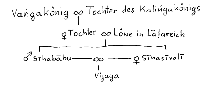
Abb.: Stammbaum Vijaya's
"Vijaya. The first Ariyan king of Ceylon. He was the eldest of the thirty two sons of Sīhabāhu, king of Lāla, and of Sīhasīvalī. Because of his evil conduct he, with seven hundred others, was deported by the king, with their heads half shaved. Their wives and children were deported with them. The children landed at Naggadīpa and the women at Mahilādīpaka (MT. 264). Vijaya and the other men landed at Suppāraka, but was obliged to leave owing to the violence of his supporters.
According to Dpv.ix.26, Vijaya went from Suppāraka to Bhārukaccha, where he stayed for three months. They reached Ceylon on the day of the Buddha's death, received the protection of the deva Uppalavanna, and thus escaped destruction by the Yakkhas. The Yakkhinī, Kuvenī, fell in love with Vijaya, and he, with her assistance, killed the Yakkhas of Lankāpura and Sirīsavatthu, and founded the city of Tambapanni. Vijaya's chief ministers, Anurādha, Upatissa, Ujjena, Uruvela and Vijita, founded separate colonies, named after themselves.
Vijaya had two children by Kuvenī, Jīvahattha and Dīpellā; but when he wished to be consecrated king, he sent for and obtained, for his wife, a daughter of the Pandu king of Madhurā. Kuvenī, thereupon, left him and was killed by the Yakkhas. Vijaya reigned for thirty eight years and was succeeded by Panduvāsudeva. For details of Vijaya's life, see Mhv.vi.38ff.; vii.6ff.; viii.1 3; Dpv.ix.6ff.
Ajātasattu and Vijaya were contemporaries, Ajātasattu’s twenty fourth year of kingship corresponding to Vijaya's sixteenth year. Dpv.iv.27; v.77."
[Quelle: Malalasekera, G. P. <1899 - 1973>: Dictionary of Pāli proper names. -- Nachdruck der Ausgabe 1938. -- London : Pali Text Society, 1974. -- 2 vol. -- 1163, 1370 S. -- ISBN 0860132692. -- s. v.]
2 Sumitta
"Sumitta. Younger brother of Vijaya and son of Sīhabāhu. His wife, Cittā, was the daughter of the Madda King. He reigned in Sīhapura, and was invited by Vijaya to Ceylon to succeed to the throne; but he sent, instead, his son Panduvāsudeva. He had two other sons. Mhv.vi.38; viii.2, 6, 10."
[Quelle: Malalasekera, G. P. <1899 - 1973>: Dictionary of Pāli proper names. -- Nachdruck der Ausgabe 1938. -- London : Pali Text Society, 1974. -- 2 vol. -- 1163, 1370 S. -- ISBN 0860132692. -- s. v.]
39. Vijayo visamācāro,
āsi tamparisā pi
ca;
sāhasāni anekāni,
dussahāni kariṃsu te.
39. Vijaya und seine Umgebung hatten schlechtes Verhalten, sie begangen viele unerträgliche Gewalttaten.
40. Kuddho mahājano rañño,
tam atthaṃ paṭivedayi;
rājā te saññapetvāna,
puttaṃ ovadi sādhukaṃ.
40. Empört berichtete die Bevölkerung dies dem König. Der König beschwichtigte sie und ermahnte seinen Sohn sehr.
41. Sabbaṃ tatheva dutiyaṃ,
ahosi
tatiyaṃ pana;
kuddho mahājano āha,
puttaṃ ghātehi te iti.
41. All dies wiederholte sich ein zweites Mal. Beim dritten Mal aber sprach die aufgebrachte Bevölkerung: "Töte deinen Sohn!"
42. Rājā’ha Vijayaṃ tañ ca,
parivārañ ca
tassa taṃ;
satta satāni purise,
kāretvā addhamuṇḍake.
43. Nāvāya pakkhipāpetvā,
vissajjāpesi
sāgare;
tathā tesaṃ bhariyāyo,
tatheva ca kumārake.
42./43. Da ließ der König den Vijaya und sein Gefolge -- insgesamt 700 Mann -- am halben Kopf kahl scheren1, ließ sie in ein Schiff werfen und ließ sie aufs Meer treiben. Desgleichen tat er mit ihren Gattinnen und Kindern.
Kommentar:
1 kahl scheren bedeutet, dass man jemanden zum Unfreien/Sklaven macht
44. Visuṃ visuṃ te vissaṭṭhā,
purisitthikumārakā;
visuṃ visuṃ dīpakasmiṃ,
okkamiṃsu vasiṃsu ca.
44. Da sie getrennt treiben gelassen worden waren, landeten Männer, Frauen und Kinder getrennt auf [drei verschiedenen] Inseln und wohnten dort.
45. Naggadīpo ti ñāyittha,
kumārokkantadīpako;
bhariyokkantadīpo tu,
Mahilādīpako iti.
45. Das Inselchen, auf dem die Kinder landeten, wurde Naggadīpa [Insel der Nackten = Kinder] genannt, die Insel, auf der die Frauen landeten, Mahīlādīpaka [Fraueninselchen].
46. Suppārake paṭṭanamhi,
Vijayo pana
okkami;
parisāsāhasen' ettha,
bhīto nāvaṃ punā’ruhi.
46. Vijaya aber landete im Hafen Suppāraka1, er geriet aber dort in Gefahr wegen der Gewalttaten seines Gefolges und schiffte wieder ein.
Kommentar:
1 Suppāraka: heute Sopāra, nördlich von Bombay
Abb.: Lage von Suppāraka/Sopāra (©MS Encarta)
"Sopara was an ancient port town near the present day Bombay [Mumbai मुंबई] exurb of Nala Sopara. During ancient times, the town was the largest on India's west coast, trading with Mesopotamia, Egypt, Cochin, Arabia and Eastern Africa. Coins and artefacts can be found in the Asiatic Society of Bombay."
[Quelle: http://en.wikipedia.org/wiki/Sopara. -- Zugriff am 2006-04-30]
47. Laṃkāyaṃ Vijayasanāmako kumāro;
otiṇṇo thiramati Tambapaṇṇidesea;
sālānaṃ yamakaguṇānam antarasmiṃ;
nibbātuṃ sayitadine tathāgatassa.
a Burm.: Tambapaṇṇidīpe
47. In Lankā landete der Prinz Vijaya, der Entschlossene, im Tambapaṇṇigebiet1 am Tag, da der Wahrheitsfinder [Buddha Gotama] zwischen den Zwillings-Salbäumen2 lag, um zu erlöschen3.
Kommentar:
Versmaß:
Praharṣiṇī
(13 Silben: 3.10.; Schema: ma na ja ra ga: tryāśābhir manajaragāḥ Praharṣiṇīyam: "In der Praharṣiṇī ist ma na ja ra ga mit Zäsur nach drei und zehn Silben (āśā = die zehn Himmelrichtungen: vier Haupt- und vier Zwischenhimmelsrichtungen sowie unten und oben).")ˉˉˉ˘˘˘˘ˉ˘ˉ˘ˉˉ
ˉˉˉ˘˘˘˘ˉ˘ˉ˘ˉˉ
ˉˉˉ˘˘˘˘ˉ˘ˉ˘ˉˉ
ˉˉˉ˘˘˘˘ˉ˘ˉ˘ˉˉZur Metrik siehe:
Payer, Alois <1944 - >: Einführung in die Exegese von Sanskrittexten : Skript. -- Kap. 8: Die eigentliche Exegese, Teil II: Zu einzelnen Fragestellungen synchronen Verstehens. -- Anhang B: Zur Metrik von Sanskrittexten. -- URL: http://www.payer.de/exegese/exeg08b.htm
Abb.: Landung Vijayas in Tambapaṇṇi, nach einem Fresko in Ajanta
[Bildquelle: Wikipedia]1 Tambapaṇṇi
"Tambapaṇṇi The name given to that district in Ceylon where Vijaya landed after leaving Suppāraka (Mhv.vi.47; Dpv.ix.30). It is said to have been so called because when Vijaya's followers, having disembarked from the ship, sat down there, wearied, resting their hands on the ground, they found them coloured by the red dust that lay there. Later on Vijaya founded his capital in Tambapanni, and following that the whole island came to bear the same name (Dpv.vii.38-42). Tambapanni was originally inhabited by Yakkhas, having their capital at Sirīsavatthu (q.v.). The Valāhassa Jātaka (J.ii.129) speaks of a Tambapannisara. According to the Samyutta Commentary (ii.83; but in VbhA.p.444 it is spoken of as tiyojana satika), the Tambapannidīpa was one hundred leagues in extent.
Anurādhapura formed the Majjhimadesa in Tambapannidīpa, the rest being the Paccantimadesa (AA.i.265).
In Asoka's Rock Edicts II. and XIII. Tambapanni is mentioned as one of the Pratyanta desas, together with Coda, Pāndya, Satiyaputta, Keralaputta, and the realm of Antiyaka Yonarāja, as an unconquered territory with whose people Asoka was on friendly terms. Vincent Smith (Asoka (3rd edn.), p.163; but see Ind. Antiq., 1919, p.195f ) identifies this, not with Ceylon, but with the river Tāmraparni in Tinnevelly."
[Quelle: Malalasekera, G. P. <1899 - 1973>: Dictionary of Pāli proper names. -- Nachdruck der Ausgabe 1938. -- London : Pali Text Society, 1974. -- 2 vol. -- 1163, 1370 S. -- ISBN 0860132692. -- s. v.]
"Names of Sri Lanka Sri Lanka is a country that has been known by many names. The existence of the island has been known to the Indic, Chinese, Arabic, and Western civilisations for many millennia and the various names ascribed to the island over time reflect this.
The island was renamed Sri Lanka, meaning "resplendent land" in Sanskrit, in 1972, before which it was known by a variety of names. This represented a modern adoption of a name of ancient lineage, deriving from the Ramayana, in which the island was simply called Lanka. Other names using a form of Sri include the traditional Sinhala Siri Laka and Shri Lanka, preferred by the former Sri Lankanpresident Premadasa but never gaining wider appeal.
In the Ramayana, it was also known as Lankadeepa, with deepa meaning "island". Another traditional Sinhala names for Sri Lanka was Lakdiva, with diva also meaning "island". A further traditional name is Lakbima. Lak in both cases is derived again from Lanka.
Of the same etymology, Sri Lanka is known locally in Tamil as Ilankai [இலங்கை]. The appellation Lanka, however, was unknown to the Greeks, from whom most Western names would be derived, and is not seen in any Western names until 1972.
Sinhala and SihalamThe English name Ceylon and a host of other related words all most likely trace their roots back to the Sanskrit sinha ("lion"). With the Sanskrit sinha as its root, sinhala means "the dwelling place of a lion". As lions have never lived on Sri Lanka in the wild, sinhala is most often taken to mean a lion-like man - a hero - presumably Vijaya's grandfather. The Pâli form of the Sanskrit sinhala is sihalam (pronounced silam), deriving from sinhala.
SalikeThe second-century Greek geographer Ptolemy [Κλαύδιος Πτολεμαῖος] called the inhabitants Salai and the island Salike ("country of the Salai"), most widely believed to derive from the Pâli sihalam.
There are some alternative arguments as to the origin of Salike. Some argue that another Indian name for the island - Salabha ("rich island") - is its source. Others argue that it came via the Egyptian Siela Keh ("land of Siela"), even more similar to Cosmas' Sielen and still of the same ultimate origin. Some scholars also hold that it was merely a corruption, probably by the Greek sailors who traveled to Sri Lanka, of Simhalaka.
Simoundou and related namesPtolemy also called the island Simoundou or Simundu (pronounced Silundu), also believed to derive ultimately from the Sanskrit sinhala. From Ptolemy we also learn that, relative to Taprobanê, Simoundou was an ancient name for Sri Lanka (from Ptolemy's perspective, and thus even more so now).
He also called it Palai-Simundu, which is believed to either mean simply "Old Simundu", using the Greek word for "old", or alternatively to derive from the Sanskrit pali-simanta (meaning "head of the sacred law"), as Sri Lanka had by that time become an important center of Buddhism.
Ceylon and related namesAlso deriving from the Sanskrit sinhala via the Pâli sihalam, the fourth-century Roman historian Ammianus Marcellinus called the inhabitants of the island Serandives and the sixth-century Greek sailor Cosmas Indicopleustes ("Cosmas India-Voyager") called the island Sielen Diva ("island of Sielen"), with both -dives and Diva merely forms of dwîpa, meaning "island". From Sielen derived many of the other European forms: the Latin Selan, Portuguese Ceilão, Spanish Celián, French Selon, Dutch Zeilan, Ceilan and Seylon, and of course the English Ceylon. Further variants include Seylan, Zeylan and Ceylan. Today, Ceylon and its equivalents in other languages are still occasionally used.
This origin is shared with many other names, such as Serendiva, Serendivus, Sirlediba, Sihala, Sinhale, Seylan, Sinhaladveepa, Sinhaladweepa, Sinhaladvipa, Sinhaladwipa,Simhaladveepa, Simhaladweepa, Simhaladvipa, Simhaladwipa, Sinhaladipa, Simhaladeepa, etc. Many of these names appear to reflect nothing more than the numerous orthographic variations in the way these names have been transliterated into Western languages, including changing the n to m, changing the a at the end of Sinhala to an e, writing the vowel in the penultimate syllable as an i or an ee, changing the v to a w, omitting vowels completely, and so on.
The tenth-century historian Abu Rihan Muhammad bin Ahmad [Persian: ابوریحان بیرونی; Arabic: أبو الريحان البيروني], or Alberuni, called the island Singal-Dip, also derived from sinhala and a form of the word meaning "island". However, in Arabic, Sri Lanka ultimately came to be known as Serendib or Sarandib, which led to the Persian Serendip (as used in the Persian fairy tale The Three Princes of Serendip, whose heroes were always making discoveries of things they were not seeking, from which Horace Walpole in 1754 would ultimately coin the English word serendipity). An Arabic form of more recent vintage than Sarandib, Sailan, later came to be via predecessor words in Arabic Tilaan and Cylone, also sharing the same root as Ceylon.Heladiva and related names
The names Heladiva and Heladveepa have two possible origins, a point of hot debate between certain Sri Lankans. Some argue that these are nothing more than an additional type of name sharing the same origin as those related to Ceylon mentioned above, simply having been shortened by dropping the Sin or Sim. Others argue that the Hela were a separate people living in Sri Lanka before the arrival of the Indian invaders, the Dravidians or specifically the Tamils of South India. Those who make this distinguishment are more likely to use these names to describe Sri Lanka.
Sivuhelaya may also be a name of similar origin, although it is very obscure.
Tâmraparnî and related namesOther names have also been used in the West to describe the island. The Indian conqueror Vijaya named the island Tâmraparnî ("copper-colored leaf"), a name which was adopted into Pâli as Tambapanni. The accounts of Alexander the Great's [Μέγας Αλέξανδρος] officers and others like forth-century BCE Greek geographer Megasthenes [Μεγασθενής], based on information they obtained from Greek and Sri Lankan travellers, called Sri Lanka Taprobanê [Ταπραβάνη], generally regarded as a transliteration of Tâmraparnî. Later, the seventeenth-century English poet John Milton borrowed this for his epic English-language poem Paradise Lost.
An alternative etymology for the Greek Taprobanê is from the Sanskrit Tambrapani ("great pond" or "pond covered with red lotus"), most likely in association with the great tanks for which Sri Lanka is famed. A third is that it derived its name from a river; the name of the river is Tāmaraparnī or Tamiravarani or Taamravarni, which is North of Sri Lanka and is a combination of the Sanskrit taamra ("coppery") and varna ("color").
Other namesOther names include the Tamil Ilanare, the Arabic Tenerism ("isle of delight"), and the Chinese Pa-Outchow ("isle of gems"). The island has also earned at least two nicknames. First, it came to be known as the "Island of Teaching" due to the large number of Greeks and Chinese who travelled to the island to learn of Buddhism. Second, due to its shape and location in the Indian Ocean off the southeastern coast of India, some also refer to the island as India's teardrop."
[Quelle: http://en.wikipedia.org/wiki/Names_of_Sri_Lanka. -- Zugriff am 2006-05-01]
2 Zwillings-Salbäumen. Sal = Shorea robusta
Abb.: Sal-Baum -- Shorea robusta
[Quelle der Abb.: Dietrich Brandis. -- 1844. -- http://caliban.mpiz-koeln.mpg.de/~stueber/brandis/. -- Zugriff am 2001-06-11]3 d.h. nach der Theravādachronologie 543 v. Chr. Damit ist die menschliche Landnahme Lankā's auf einen für Buddhisten im Höchstmaße glücksverheißenden Tag gelegt und -- sozusagen im letzten Augenblick -- mit dem Leben Buddha Gotama's verknüpft.
Sujanapasādasaṃve gatthāyakate Mahāvaṃse Vijayāgamanaṃnāma Chaṭṭhāparicchedo.
Dies ist das sechste Kapitel des Mahāvaµsa, der zum Vertrauen und zur Erschütterung der guten Menschen verfasst wurde. Der Titel dieses Kapitels ist "Ankunft des Vijaya (in Lankā)".
1 Laṅkādīpo ayaṃ ahu sīhena sīhalā iti,
Dīpuppattiṃ imaṃ vaṃsaṃ suṇātha vacanaṃ mama.
2 Vaṅgarājassāyaṃ dhītā araññe vanagocarā,
Sīhasaṃvāsam anvāya bhātaro janayī duve.
3 Sīhabāhu ca Sīvalī kumārā cāru dassanā,
Mātā ca Susimā nāma pitā ca Sīhasavhayo
4 Atikkante soḷasavasse nikkhamitvā guhantarā,
Māpesi nagaraṃ tattha Sīhapuraṃ varuttamaṃ
5 Lāḷaraṭṭhe tahiṃ rājā Sīhaputto mahabbalo,
Anusāsi mahārajjaṃ Sīhapuravaruttame.
6 Battiṃsa bhātaro honti Sīhaputtassa atrajā,
Vijayo ca sumitto ca subhajeṭṭhabhātarā ahuṃ.
7 Vijayo nāma so kumāro pagabbho ās asikkhito,
Karoti vilopakammaṃ atikicchaṃ sudāruṇaṃ
8 Samāgatā jānapadā negamā ca samāgatā,
Upasaṅkamma rājānaṃ Vijayadosaṃ pakāsayuṃ.
9 Tesaṃ vacanaṃ sutvāna rājā kupitamānaso,
Āṇāpesi amaccānaṃ kumāraṃ nīharatha imaṃ.
10 Paricārikā ime sabbe puttadārā ca bandhavā,
Dāsidāsakammakare nīharantu janappadā.
11 Tato taṃ nīharitvāna visuṃ katvāna bandhave,
Āropetvāna te nāvaṃ vuyhitha aṇṇave tadā.
12 Pakkamantu yathākāmaṃ honti sabbe adassanaṃ,
Raṭṭhe janapade vāsaṃ mā puna āgamicchati.
13 Kumāroānaṃ ārūḷhanāvā gatā dīpaṃ avassakaṃ,
Nāmadheyyaṃ tadā āsī Naggadīpan ti vuccati.
14 Mahilānaṃ ārūḷhanāvā gatā dīpaṃ avassakaṃ,
Nāmadheyyaṃ tadā āsi Mahilāraṭṭhan ti vuccati.
15 Purisānaṃ ārūḷhanāvā apilavantā va sāgaraṃ,
Vippanaṭṭhā disāmūḷhā gatā Suppārapaṭṭanaṃ.
16 Orohetvāna Suppāraṃ sattasatañ ca te tadā,
Vipulaṃ sakkārasammānaṃ akaṃsu te Suppārakā.
17 Tesu sakkariyamānesu Vijayo ca sahāyakā,
Sabbe luddāni kammāni kurumānā nabujjhakā.
18 Pāṇaṃ adinnaṃ paradāraṃ musāvādañ ca pesuṇaṃ,
Anācārañ ca dussilyaṃ ācaranti sudāruṇaṃ.
19 Kakkhalaṃ pharusaṃ ghoraṃ kammaṃ kavā sudāruṇaṃ,
Ujjhāyetvāna mantiṃsu khippaṃ ghātema dhuttake.
20 Ojadīpo Varadīpo Maṇḍadīpo ti vā ahu,
Laṅkādīpo ca paṇṇatti Tambapaṇṇīti ñāyati.
21 Parinibbānasamaye sambuddhe dipaduttame,
Sīhabāhussāyaṃ putto Vijayo nāma khattiyo.
22 Laṅkādīpaṃ anuppatto jahetvā Jambudīpavhayaṃ."IX.
1. The island of Laṅkā was called Sīhala after the Lion (sīha); listen ye to the narration of the origin of the island which I (am going to) tell.
2. The daughter of the Vaṅga king cohabited in the forest with a lion dwelling in the wilderness, and in consequence gave birth to two children. 3. Sīhabāhu and Sīvalī were beautiful youths; the name of their mother was Susimā, and their father was called the Lion. 4. When their sixteenth year had elapsed, (Sīhabāhu) departed from his cave, and then built a most excellent town called Sīhapura. 5. The son of the Lion, a powerful king, ruled over a great kingdom, in Lāḷaraṭṭha, in the most excellent town of Sīhapura. 6. Thirty-two brothers were the sons of Sīhabāhu; Vijaya and Sumitta were the eldest among them, beautiful princes. 7. Prince Vijaya was daring and uneducated; he committed most wicked and fearful deeds, plundering the people. 8. The people from the country and the merchants assembled; they went to the king and complained against the bad conduct of Vijaya. 9. The king, having heard their speech, full of anger, gave this order to the ministers: „Remove ye that boy. 10. Let them remove from the country all those attendants, his wives, children, relations, maid-servants, man-servants, and hired workmen." 11. He was then removed, and his relations were separated from him; so they went on board ship, and (the ship) sailed away on the sea. 12. „May they drift whereever they like; they shall not show their faces again nor shall they ever come back to dwell in our kingdom and country." 13. The ship in which the children had embarked was helplessly driven to an island, the name of which was then called Naggadīpa. 14. The ship in which the wives had embarked was helplessly driven to an island, the name of which was then called Mahilāraṭṭha. 15. The ship in which the men had embarked went, sailing on the sea, losing her way and her bearings, to the port of Suppāra. 16. The people of Suppāra then invited those seven hundred men to disembark, and offered them lavish hospitality and honours. 17. During this hospitable reception Vijaya and all his followers unnoticed (?) committed barbarous deeds. 18. They made themselves guilty of drinking, theft, adultery, falsehood, and slander, of an immoral, most dreadful, bad conduct. 19. (The people) indignant at such cruel, savage, terrible and most dreadful deeds being committed against themselves, consulted together: „Let us quickly kill those rascals."
20. There is an island (formerly) called Ojadīpa, Varadīpa, or Maṇḍadīpa, the (recent) name of which is Laṅkādīpa, and which is (besides) known by the name of Tambapaṇṇi. 21.22. At the time, when Sambuddha, highest of men, attained Parinibbāna, that son of Sīhabāhu, the prince called Vijaya, having left the land called Jambudīpa, landed on Laṅkādīpa."[Quelle: Dipavamsa : an ancient historical record / ed. and translated by Hermann Oldenberg [1854 - 1920]. -- 1879. -- S. 160f.]
M = Mahāvaṃsa; EM = Extended Mahāvaṃsa; MT = Mahāvaṃsa Ṭīkā. M VI., 1-38.—The founding of Sīhapura and the ancestry of Sīhabāhu's son, Vijaya.
EM VI., 1-47.— Same as in M., but at greater length.
VI., 39-47.—Vijaya is expelled from his country and lands in Laṅkā with 700. followers. Their families stop elsewhere. VI., 48-56—Same as in M. According to MT. (e.g. 246. 5, 247.12, 249.9.)Ak. dealt quite exhaustively with the history of Vijaya and his ancestors and his deeds in Ceylon. MT. itself, however, makes very few additions to the M. account. Thus Sīhabāhu's mother is called Suppadevī (243.25, 247.18. Dpv. IX.3 calls her Susīmā). Her cousin, who later married her, is called Anura or Anurakkha (246.28) while the cave in which the lion lived was, according to UVAk. eight fathoms (249.11). MT. corrects M. and says (247.12 f) that no eatables were given by Anura to Suppadevī and her children but only gruel (yāgu). EM. does not take notice of any of these things." [Quelle: G. P. Malalasekera (1899 - 1973). -- In: Extended Mahāvaṃsa / ed. by G. P. Malalasekera. -- Colombo : Times of Ceylon, 1934. -- LVIII, 380 S. -- (Aluvihāra Series ; III). -- Reprint: Oxford : Pali Text Society, 1988. -- ISBN 0-86013-285-4. -- S. XXIIf.]
Zu Kapitel 7: Die Weihe Vijaya's zum König